
Greater Western Sydney (GWS) is a large region of the metropolitan area of Greater Sydney, New South Wales (NSW), Australia that generally embraces the north-west, south-west, central-west, far western and the Blue Mountains sub-regions within Sydney's metropolitan area and encompasses 11 local government areas: Blacktown, Blue Mountains, Camden, Campbelltown, Cumberland, Fairfield, Hawkesbury, Liverpool, Parramatta, Penrith and Wollondilly. It includes Western Sydney, which has a number of different definitions, although the one consistently used is the region composed of ten local government authorities, most of which are members of the Western Sydney Regional Organisation of Councils (WSROC). The NSW Government's Office of Western Sydney calls the region "Greater Western Sydney".

Prospect is a suburb of Sydney, in the state of New South Wales, Australia. Prospect is located 32 kilometres west of the Sydney central business district in the local government area of the City of Blacktown and a small part of Cumberland City Council, is part of the Greater Western Sydney region. One of the oldest suburbs in Sydney, Prospect takes its name from the prominent nearby landmark of Prospect Hill - from the top of which people could get a prospect of the surrounding countryside.

The Prospect Reservoir is a heritage-listed 50,200-megalitre potable water supply and storage reservoir created by the Prospect Dam, across the Prospect Creek located in the Western Sydney suburb of Prospect, in New South Wales, Australia. The eastern bounds of the reservoir are a recreational area and the western periphery are within the bounds of Western Sydney Parklands. It was added to the New South Wales State Heritage Register on 18 November 1999.

The Lower Prospect Canal Reserve is a heritage-listed former farm and public water supply canal and now bushy corridor and nature reserve stretching 7.7 kilometres (4.8 mi) through the heart of suburban Sydney, New South Wales, Australia. The lineal corridor stretches from Prospect Reservoir to Sydney Water Pipehead at Albert Street, Guildford with the majority of the reserve located in Greystanes, which is a suburb within the Cumberland Council area.

Prospect Hill, or Marrong Reserve, is a heritage-listed hill in Pemulwuy and Prospect in the greater western region of Sydney, New South Wales, Australia. Situated about 30 kilometres west of central Sydney, the hill is Sydney's largest body of igneous rock and is higher than the ridges of the Cumberland Plain around it, with its present-day highest point being 117 metres high, although before its summit was quarried away it rose to a height of 131 metres above sea level.

Petersham Reservoir is a heritage-listed water reservoir at New Canterbury Road, Petersham, Inner West Council, Sydney New South Wales, Australia. It was designed and built by the New South Wales Public Works Department. It is also known as Petersham Service Reservoir and WS089. The property is owned by Sydney Water. It was added to the New South Wales State Heritage Register on 18 November 1999.

The Upper Canal System, also called the Southern Railway Aqueduct and the Cataract Tunnel, is a heritage-listed operational gravity-fed aqueduct that supplies some of the potable water for Sydney, in New South Wales, Australia. The aqueduct comprises 54 kilometres (34 mi) of open canals, tunnels, and closed pipelines that connect the Upper Nepean Scheme with the Prospect Reservoir. The aqueduct is managed by the Sydney Catchment Authority on behalf of WaterNSW, an agency of the Government of New South Wales. It was listed on the New South Wales State Heritage Register on 18 November 1999.

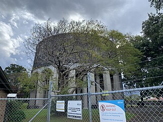
Bankstown Reservoir is a heritage-protected water tower and a local landmark situated in the Sydney suburb of Bankstown, New South Wales, Australia. Located 22 kilometres (14 mi) west of Sydney CBD, the reservoir is elevated and was built on reinforced concrete piers, which is one of the oldest of this type that is still in use.

The Boothtown Aqueduct is a heritage-listed 19th-century, Victorian Romanesque style water bridge in Greystanes, Sydney, New South Wales, Australia. Established in 1888, the aqueduct was built to cross a valley to carry water from Prospect Reservoir to residents of Greater Western Sydney.

Potts Hill Reservoirs 1 and 2 are heritage-listed reservoirs at Cooper Road, Potts Hill, City of Canterbury-Bankstown, New South Wales, Australia. It was designed by Board of Water Supply and Sewerage and built from 1880. The reservoirs are now maintained by the Board's successor, Sydney Water. It was added to the New South Wales State Heritage Register on 18 November 1999.

Drummoyne Reservoir is a heritage-listed decommissioned elevated service reservoir at Rawson Avenue, Drummoyne, City of Canada Bay, New South Wales, Australia. It was designed by engineer J. G. S. Purvis from the Metropolitan Board of Water Supply and Sewerage and built from 1910 to 1913, with the Board responsible for the construction of the substructure and Poole & Steele Ltd responsible for the tank manufacture. It is also known as WS0038 and Drummoyne Elevated Steel Reservoir. It was added to the New South Wales State Heritage Register on 15 November 2002. Sydney Water sold the property in September 2018 to owners of a chain of childcare centres, who plan to convert the site into a childcare centre while retaining most of the heritage structure.

The Waverley Reservoirs are four reservoirs, of which two are heritage-listed, located at Paul Street, Bondi Junction, New South Wales, Australia. They were designed and built by the Public Works Department. The property is owned by Sydney Water.
The Penshurst Reservoirs are heritage-listed reservoirs located at Laycock Road, Penshurst in the Georges River Council local government area of New South Wales, Australia. They were designed and built during 1895 by the NSW Public Works Department. The reservoirs are also known as WS87 & R88, Penshurst Elevated Steel Reservoir No 2 and Penshurst Elevated Concrete Reservoir No 3. The property is owned by Sydney Water, an agency of the Government of New South Wales. The site was added to the New South Wales State Heritage Register on 18 November 1999.

The Guildford West pipehead and water supply canal is a heritage-listed sewerage infrastructure and water supply canal located at Frank Street, Guildford in the Cumberland Council local government area of New South Wales, Australia. It is also known as Headworks; Industrial Archaeological Site. The property is owned by Sydney Water, an agency of the Government of New South Wales. It was added to the New South Wales State Heritage Register on 15 November 2002.

The Prospect Reservoir Valve House is a heritage-listed waterworks located at East of Reservoir, Prospect in the City of Blacktown local government area of New South Wales, Australia. Situated on the grounds of Prospect Nature Reserve, it was designed and built by The Metropolitan Board of Water Supply and Sewerage. The property is owned by Sydney Water and Water NSW, agencies of the Government of New South Wales. It was added to the New South Wales State Heritage Register on 18 November 1999.

The Ashfield Reservoir is a heritage-listed reservoir located at Holden Street, Ashbury, New South Wales, a suburb of Sydney, Australia. It was designed and built by the Metropolitan Board of Water Supply and Sewerage. It is also known as Ashfield Reservoir (Elevated) and WS 0003. The property is owned by Sydney Water. It was added to the New South Wales State Heritage Register on 15 November 2002.
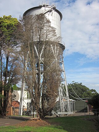
The Wahroonga Reservoir is a heritage-listed reservoir located at 1678 Pacific Highway and Woonona Avenue in the Sydney suburb of Wahroonga in the Ku-ring-gai Council local government area of New South Wales, Australia. It was designed and built by the Metropolitan Board of Water Supply and Sewerage in 1915. It is also known as Wahroonga Reservoir (Elevated) . The property is owned by Sydney Water, a State-owned statutory corporation of the Government of New South Wales. It was added to the New South Wales State Heritage Register on 18 November 1999.

The Pymble Reservoirs No. 1 and No. 2 are two heritage-listed reservoirs located at Pacific Highway in the Sydney suburb of Pymble in the Ku-ring-gai Council local government area of New South Wales, Australia. The reservoirs are also known as Pymble Reservoir No. 1 (Covered) and (WS 0097); and Pymble Reservoir No. 2 (Covered) and (WS 0098). The property is owned by Sydney Water, a State-owned statutory corporation of the Government of New South Wales. The reservoirs were added to the New South Wales State Heritage Register on 15 November 2002.
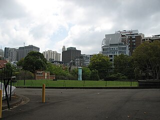
The Crown Street Reservoir is a heritage-listed reservoir located at 285 Crown Street, Surry Hills, City of Sydney, New South Wales, Australia. It was built by Donohoe and Vaughan. It is also known as Crown Street Reservoir & Site and WS 0034. The property is owned by Sydney Water, an agency of the Government of New South Wales. It was added to the New South Wales State Heritage Register on 18 November 1999.

Prospect Nature Reserve is a nature reserve and recreational area that is situated in the western suburbs of Sydney, New South Wales, Australia, which incorporates the Prospect Reservoir, and also features picnic spots, lookouts, walking tracks and BBQ areas within the Australian bush. It is located within the Blacktown City local government area, but is also close to the boundaries of Cumberland Council and the City of Fairfield.


