Prospect, New South Wales

Last updated

Prospect
Sydney,  New South Wales
Prospect Reservoir Sunset.jpg
The Prospect Reservoir at sunset
Prospect, New South Wales
Map
Population4,716 (2016 census) [1]
Established1791 [2]
Postcode(s) 2148
Elevation78 m (256 ft)
Location32 km (20 mi) west of Sydney CBD
LGA(s) City of Blacktown
State electorate(s) Prospect
Federal division(s)
Mean max tempMean min tempAnnual rainfall
23.1 °C
74 °F
12.2 °C
54 °F
870.6 mm
34.3 in
Suburbs around Prospect:
Seven Hills Toongabbie Girraween
Blacktown Prospect Pemulwuy
Eastern Creek Wetherill Park Smithfield

Prospect is a suburb of Sydney, in the state of New South Wales, Australia. Prospect is located 32 kilometres west of the Sydney central business district in the local government area of the City of Blacktown and a small part of Cumberland City Council, is part of the Greater Western Sydney region. One of the oldest suburbs in Sydney, Prospect takes its name from the prominent nearby landmark of Prospect Hill - from the top of which people could get a prospect of (see a great distance) the surrounding countryside.

Contents

Initially a settlement for emancipated convicts, it later became a village. [3] Since colonisation, settlers cleared larger areas of land to raise livestock, build churches, inns, schools, shops and a large reservoir. [4] Naturalist Charles Darwin visited Prospect in January 1836, to observe the geology. [5]

History

Prior to the arrival of the First Fleet in 1788, Prospect was inhabited by different groups of the Darug people including the Warmuli. The Aboriginals there were of the woods culture. As European settlement expanded, the aboriginal people's ability to pursue their traditional lifestyle, which was already severely limited, disappeared. Prospect Hill had been the frontier, which was the first, and perhaps only, area where large scale organised resistance by aboriginal people took place. [6]

Lieutenant Watkin Tench most likely named Prospect Hill in April 1790. In July 1791, thirteen grants of land at Prospect were made to emancipated convicts. [7] [8] In January 1794 David Collins reported that the Prospect Hill farmers were the most productive in the colony. [9]

Prospect became the boundary between colonists and indigenous Australians. Hostility grew until by 1797, where a state of guerrilla warfare existed between indigenous people and the settler communities at Prospect and Parramatta. The aboriginal people were led by their leader, Pemulwuy, a member of the Bidjigal tribe who occupied the land. [10] Pemulwuy was the main leader of raids against the colony in the 1790s. In 1797 the war escalated; his guerrillas started regular raids on settlements in the Parramatta and Prospect Hill areas. British military expeditions failed to locate and capture Pemulwuy. [11]

Shortly after 1808, William Lawson was appointed aide-de-camp to George Johnston, was granted 500 acres (2.0 km2) at Prospect and built a large house there, which he named Veteran Hall. In the 1880s most of the property was submerged in what is now Prospect reservoir. [12]

On 30 January 2004 the eastern part of Prospect, which includes the quarry gap, became a new suburb called Pemulwuy containing the new housing estates of Lakeside and Nelson's Ridge and the industrial area within the oval-shaped ridge of Prospect Hill. So most of Prospect Hill is no longer within the suburb of Prospect. [13]

Quarrying companies gradually took over more and more of Prospect Hill, mining the dolerite for use as roadstone until it was almost all gone and much of the hill with it. The Prospect quarry, which is now part of Pemulwuy, is formed by an intrusion of dolerite rock into Ashfield Shale . At least seven different rock types occur in the intrusion. The material is predominantly coarse grained picrite with olivine-dolerite and dolerite. [14] Quarrying in the area last occurred in 2007. In the early 2010s, the 330ha quarry gap was transformed into light industry area. Prospect Highway now winds through the gap. [15] [16]

Heritage listings

Prospect has a number of heritage-listed sites, including:

Geography

Philip Gidley King mentions that the landscape of Prospect is "a very pleasant tract of country, which, from the distance the trees grew from each other, and the gentle hills and dales, and rising slopes covered with grass, appeared like a vast park. The soil from Rose Hill to Prospect-Hill is nearly alike, being a loam and clay." The tree cover was mainly the eucalypts, grey box and forest red gum. Spotted gum ( Corymbia maculata ) is also known to have occurred in the Prospect area. [27]

Climate

Prospect has a humid subtropical climate (Cfa). Summer weather is warm to hot, and may be humid or dry. Like most of western Sydney, rainfall peaks in late summer to early autumn and more dry conditions occur between late winter and early spring, although rainfall can be erratic. [28] [29] The suburb gets 104.2 clear days annually, with the most sunniest days being in August (13.2) and least in February (5.0 days).

Prospect is usually a few degrees warmer than the Sydney CBD on most spring and summer days. In a few cases there has been a +10-degree differential (this is mostly when northwesterlies bring hot winds from the desert that raise temperatures up to +40 °C (104 °F). However, Prospect is usually a few degrees cooler on most nights of the year, because of its distance from the coast. The highest temperature recorded at Prospect was 45.1 °C (113.2 °F) on 7 January 2018. The lowest temperature recorded was −0.8 °C (30.6 °F) on 30 June 2010. [30] Annually, there are 3.2 days where temperatures go below 2 °C. [31]

Climate data for Prospect Reservoir 1991–2020 averages, 1887–present extremes
MonthJanFebMarAprMayJunJulAugSepOctNovDecYear
Record high °C (°F)47.0
(116.6)
46.4
(115.5)
39.5
(103.1)
37.1
(98.8)
29.4
(84.9)
25.6
(78.1)
26.5
(79.7)
29.4
(84.9)
35.0
(95.0)
39.0
(102.2)
42.0
(107.6)
44.4
(111.9)
47.0
(116.6)
Average high °C (°F)29.3
(84.7)
28.6
(83.5)
26.8
(80.2)
24.1
(75.4)
20.7
(69.3)
17.7
(63.9)
17.2
(63.0)
19.3
(66.7)
22.4
(72.3)
24.8
(76.6)
26.1
(79.0)
28.0
(82.4)
23.8
(74.8)
Average low °C (°F)18.0
(64.4)
18.0
(64.4)
16.2
(61.2)
12.9
(55.2)
9.7
(49.5)
6.1
(43.0)
6.6
(43.9)
6.6
(43.9)
9.5
(49.1)
12.1
(53.8)
14.5
(58.1)
16.4
(61.5)
12.3
(54.1)
Record low °C (°F)10.0
(50.0)
10.8
(51.4)
7.9
(46.2)
3.6
(38.5)
1.2
(34.2)
−0.8
(30.6)
−0.6
(30.9)
−0.5
(31.1)
1.7
(35.1)
4.5
(40.1)
6.8
(44.2)
7.8
(46.0)
−0.8
(30.6)
Average precipitation mm (inches)96.4
(3.80)
126.9
(5.00)
97.4
(3.83)
67.4
(2.65)
49.5
(1.95)
76.1
(3.00)
40.7
(1.60)
39.7
(1.56)
42.2
(1.66)
55.3
(2.18)
77.1
(3.04)
75.5
(2.97)
845.0
(33.27)
Average precipitation days (≥ 1mm)8.38.79.26.55.37.05.64.25.16.68.28.282.9
Average afternoon relative humidity (%)52545550575452434544515151
Source 1: Prospect Reservoir (1991–2020 averages) [32]
Source 2: Prospect Reservoir (1965–2018 extremes) [31] Horsley Park (1997–present extremes) [33]

Landmarks

St Bartholomew's ProspectNSWStBarts.jpg
St Bartholomew's

Transport

Prospect is adjacent to the Great Western Highway and the M4 Motorway, providing road access to the western sections of the city and eastward to the Sydney CBD.

The Prospect Highway links Prospect to central Blacktown.

Blacktown railway station provides access to the Sydney Trains and NSW TrainLink networks, especially Sydney Trains' North Shore & Western Line. Several bus companies offer connecting services between Prospect and Blacktown, via Blacktown Road.

Demographics

Ancestry

According to the 2011 census, the most common ancestries in Prospect were Australian 20.0%, English 16.1%, Maltese 6.2%, Irish 5.0% and Indian 4.6%. [1]

According to the 2016 census, the most common ancestries in Prospect were English 15.8%, Australian 15.7%, Indian 6.4%, Maltese 5.3% and Irish 4.8%. [37]

Country of birth

62.0% of people were born in Australia. The other most common countries of birth were Fiji 3.0%, Philippines 2.8%, India 2.5%, Malta 2.3% and England 1.9%. 35.3% of people had both parents born in Australia and 53.1% of people had both parents born overseas. [1]

According to the 2016 census, 56.4% of people were born in Australia. The most common countries of birth were India 4.6%, Philippines 3.1%, Fiji 3.0%, Malta 2.1% and Sri Lanka 2.0%. [38]

Language

61.4% of people only spoke English at home. Other languages spoken at home included Arabic 4.7%, Hindi 4.1%, Greek 2.9%, Maltese 2.5% and Cantonese 1.8%. [1]

Religion

The most common responses for religion in Prospect were Catholic 38.4%, Anglican 12.0%, No Religion 10.2%, Eastern Orthodox 5.7% and Hinduism 5.6%. [1]

Notable residents

Notable people who have resided in the suburb include:

Related Research Articles

<span class="mw-page-title-main">Parramatta</span> Suburb of Sydney, New South Wales, Australia

Parramatta is a suburb and major commercial centre in Greater Western Sydney, located in New South Wales, Australia. It is located approximately 24 kilometres (15 mi) west of Central Sydney, on the banks of the Parramatta River. Parramatta is the administrative seat of the local government area of the City of Parramatta and is often regarded as the main commercial centre of Greater Western Sydney Metropolitan area. Parramatta also has a long history as a second administrative centre in the Sydney metropolitan region, playing host to a number of state government departments as well as state and federal courts. It is often colloquially referred to as "Parra".

<span class="mw-page-title-main">Richmond, New South Wales</span> Town in New South Wales, Australia

Richmond is a town in New South Wales, in the local government area of the City of Hawkesbury. It is located 19 metres above sea level on the alluvial Hawkesbury River flats, at the foot of the Blue Mountains on the Cumberland Plain. It is about 65 km by road from Sydney and about 78 km by road from Lithgow.

<span class="mw-page-title-main">The Rocks, New South Wales</span> Suburb of Sydney, New South Wales, Australia

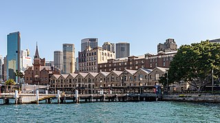
The Rocks is a suburb, tourist precinct and historic area of Sydney's city centre, in the state of New South Wales, Australia. It is located on the southern shore of Sydney Harbour, immediately north-west of the Sydney central business district.

<span class="mw-page-title-main">Surry Hills, New South Wales</span> Suburb of Sydney, New South Wales, Australia

Surry Hills is an inner-east suburb of Sydney, in the state of New South Wales, Australia. Surry Hills is immediately south-east of the Sydney central business district in the local government area of the City of Sydney. Surry Hills is surrounded by the suburbs of Darlinghurst to the north, Chippendale and Haymarket to the west, Moore Park and Paddington to the east and Redfern to the south. It is often colloquially referred to as "Surry".

<span class="mw-page-title-main">Greater Western Sydney</span> Region in New South Wales, Australia

Greater Western Sydney (GWS) is a large region of the metropolitan area of Greater Sydney, New South Wales (NSW), Australia that generally embraces the north-west, south-west, central-west, far western and the Blue Mountains sub-regions within Sydney's metropolitan area and encompasses 13 local government areas: Blacktown, Blue Mountains, Camden, Campbelltown, Canterbury-Bankstown, Cumberland, Fairfield, Hawkesbury, Hills Shire, Liverpool, Parramatta, Penrith and Wollondilly. It includes Western Sydney, which has a number of different definitions, although the one consistently used is the region composed of ten local government authorities, most of which are members of the Western Sydney Regional Organisation of Councils (WSROC). Penrith, Hills Shire & Canterbury-Bankstown are not WSROC members. The NSW Government's Office of Western Sydney calls the region "Greater Western Sydney".

<span class="mw-page-title-main">The Hills Shire</span> Local government area in New South Wales, Australia

The Hills Shire is a local government area in the Greater Sydney region of Sydney, New South Wales, Australia. The suburb is north-west of the Sydney central business district, and encompasses 401 square kilometres (155 sq mi) stretching from the M2 Hills Motorway in the south to Wiseman's Ferry on the Hawkesbury River in the north. The Hills Shire had a population of 157,243 as at the 2016 census.

<span class="mw-page-title-main">Seven Hills, New South Wales</span> Suburb of Sydney, New South Wales, Australia

Seven Hills is a suburb in the Greater Western Sydney region of Sydney, in the state of New South Wales, Australia, located 33 kilometres North West of the Sydney central business district. Seven Hills is within the local government areas of the City of Parramatta and Blacktown City councils.

<span class="mw-page-title-main">Wentworthville, New South Wales</span> Suburb of Sydney, New South Wales, Australia

Wentworthville is a suburb in Sydney, in the state of New South Wales, Australia. Wentworthville is located 27 kilometres west of the Sydney central business district and is part of the Greater Western Sydney region. Wentworthville is split between the local government areas of the City of Parramatta and the Cumberland Council. Wentworthville is colloquially known as 'Wenty'.

<span class="mw-page-title-main">Berrima, New South Wales</span> Town in New South Wales, Australia

Berrima is a historic village in the Southern Highlands of New South Wales, Australia, in Wingecarribee Shire. The village, once a major town, is located on the Old Hume Highway between Sydney and Canberra. It was previously known officially as the Town of Berrima. It is close to the three major towns of the Southern Highlands: Mittagong, Bowral and Moss Vale.

<span class="mw-page-title-main">Blacktown City Council</span> Local government area in New South Wales, Australia

Blacktown City Council is a local government area in Western Sydney, situated on the Cumberland Plain, approximately 35 kilometres (22 mi) west of the Sydney central business district, in the state of New South Wales, Australia. Established in 1906 as the Blacktown Shire and becoming the Municipality of Blacktown in 1961 before gaining city status in 1979, the City occupies an area of 246.9 square kilometres (95.3 sq mi) and has a population of 366,534, making it the second most populous local government area in Sydney.

<span class="mw-page-title-main">Rouse Hill, New South Wales</span> Suburb of Sydney, New South Wales, Australia

Rouse Hill is a suburb of Sydney, in the state of New South Wales, Australia. Rouse Hill is located in the Hills District, 43 kilometres north-west of the Sydney central business district and 19 kilometres north-west of the Parramatta central business district. It is in the local government areas of The Hills Shire and City of Blacktown. Rouse Hill Town Centre is at the heart of the suburb, which contains a busy Town Square.

<span class="mw-page-title-main">Rosehill, New South Wales</span> Suburb of Sydney, New South Wales, Australia

Rosehill is a suburb of Sydney, in the state of New South Wales, Australia. Rosehill is located 18 kilometres west of the Sydney central business district in the local government area of the City of Parramatta and is part of the Greater Western Sydney region.

<span class="mw-page-title-main">Box Hill, New South Wales</span> Suburb of Sydney, New South Wales, Australia

Box Hill is a suburb of Sydney, in the state of New South Wales, Australia. Box Hill is located 42 kilometres north-west of the Sydney central business district in the local government area of The Hills Shire and is part of the Hills District region.

<span class="mw-page-title-main">Pemulwuy, New South Wales</span>

Pemulwuy is a suburb in Greater Western Sydney, in the state of New South Wales, Australia. Pemulwuy is located 30 kilometres west of the Sydney central business district in the local government area of the Cumberland Council. Pemulwuy is home to the highest point between the Blue Mountains and Sydney, the summit of Prospect Hill.

<span class="mw-page-title-main">Upper Nepean Scheme</span>

The Upper Nepean Scheme is a series of dams and weirs in the catchments of the Cataract, Cordeaux, Avon and Nepean rivers of New South Wales, Australia. The scheme includes four dams and two weirs, and a gravity-fed canal system that feeds into a large storage reservoir to provide water to the Macarthur and Illawarra regions, the Wollondilly Shire, and metropolitan Sydney. The four dams and associated infrastructure are individually listed on the New South Wales State Heritage Register.

<span class="mw-page-title-main">The Hill, New South Wales</span> Suburb of Newcastle, New South Wales, Australia

The Hill is an inner city, residential suburb of Newcastle, in the Hunter Region of New South Wales, Australia, located immediately south of Newcastle's central business district. The Hill is filled with historic Victorian terraces and is the site of a historic convict prison block. As of January 2021, the average house price in The Hill was A$1.92m.
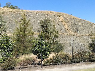
<span class="mw-page-title-main">Prospect Hill (New South Wales)</span>

Prospect Hill is a heritage-listed hill in Pemulwuy and Prospect in the greater western region of Sydney, New South Wales, Australia. Situated about 30 kilometres west of central Sydney, the hill is Sydney's largest body of igneous rock and is higher than the ridges of the Cumberland Plain around it, with its present-day highest point being 117 metres high, although before its summit was quarried away it rose to a height of 131 metres above sea level.

<span class="mw-page-title-main">St Bartholomew's Anglican Church and Cemetery, Prospect</span> Church in New South Wales, Australia

St Bartholomew's Anglican Church and Cemetery is a heritage-listed former Anglican church and cemetery at Ponds Road, Prospect, City of Blacktown, New South Wales, Australia. It was designed by Henry Robertson and built from 1838 to 1840 by James Atkinson. It was added to the New South Wales State Heritage Register on 2 April 1999. Since 1975, the site has been leased to the Council of the City of Blacktown.

<span class="mw-page-title-main">Prospect Nature Reserve</span>

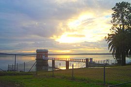
Prospect Nature Reserve is a nature reserve and recreational area that is situated in the western suburbs of Sydney, New South Wales, Australia, which incorporates the Prospect Reservoir, and also features picnic spots, lookouts, walking tracks and BBQ areas within the Australian bush. It is located within the Blacktown City local government area, but is also close to the boundaries of Cumberland Council and the City of Fairfield.

<span class="mw-page-title-main">Prospect dolerite intrusion</span> Landform of Sydney

The Prospect dolerite intrusion, or Prospect intrusion, is a Jurassic picrite or dolerite laccolith that is situated in Sydney, New South Wales, Australia. Lying in the heart of Cumberland Plain, in the suburb of Pemulwuy, the intrusion is Sydney's largest body of igneous rock, rising to a height of 117 metres (384 ft) above sea level. The site is formed by an intrusion of dolerite rock into Ashfield Shale. At least seven different rock types occur in the intrusion.

References

  1. 1 2 3 4 5 Australian Bureau of Statistics (27 June 2017). "Prospect (State Suburb)". 2016 Census QuickStats. Retrieved 15 March 2018. OOjs UI icon edit-ltr-progressive.svg
  2. Ryan, R.J., Land Grants 1788-1809, Australian Documents Library, Sydney, 1981
  3. Crittenden, V., On the track of Watkin Tench in MARGIN: Life & Letters in Early Australia, July–August 2003 issue.
  4. Jones, R., Firestick farming in Australian Natural History, 16, (September 1969), pp 224-228
  5. Darwin, C., Notes on the Geology of places visited during the Voyage, p 814 quoted in Mindat: Prospect, New South Wales by Keith Compton, http://www.mindat.org/article.php/1623/%3Cl+id%3D146488%3EProspect%3C_l%3E%2C+%3Cl+id%3D66%3ENew+South+Wales%3C_l%3E
  6. Flynn, M., Holroyd History and the Silent Boundary Project, Holroyd City Council, August 1997.
  7. Caley, G., (Currey, C., ed.) Reflections on the Colony of NSW, Landsdowne Press, Melbourne, 1966.
  8. Tench, W., A Complete Account of the Settlement at Port Jackson in New South Wales, London, G. Nicol and J. Sewell, 1793.
  9. Britton (ed), Governor Phillip to Lord Sydney 15 May 1788 in Historical Records of New South Wales Vol 1 Part 2: Phillip 1783-1792, Sydney, 1892.
  10. 1 2 Willey, K., When the sky fell down : the destruction of the tribes of the Sydney region, 1788-1850s, Collins, Sydney, 1979
  11. Collins, D., An Account of the English Colony in New South Wales, Vol. 1, Cadell and Davies, London, 1798.
  12. although Veteran Hall itself was well above the water level. In 1912 it was used by the army and many of the larger rooms subdivided, giving rise to a myth that it had been a "forty-roomed mansion" in Lawson's time. The house was demolished in 1926. E. W. Dunlop. Lawson, William (1774 - 1850). Australian Dictionary of Biography, online edition. Australian National University. Retrieved 29 August 2006.
  13. Geographical Names Board of New South Wales
  14. Mindat: Prospect, New South Wales
  15. Sydney's Forgotten Quarry Railways - Oakes, John pp9-27 ISBN   0-9757870-3-9
  16. Historic Prospect Quarry to become warehouse distribution centre and employ 1000 people by The Daily Telegraph
  17. "Upper Canal System (Pheasants Nest Weir to Prospect Reservoir)". New South Wales State Heritage Register . Department of Planning & Environment. H01373. Retrieved 18 May 2018. CC-BY icon.svg Text is licensed by State of New South Wales (Department of Planning and Environment) under CC-BY 4.0 licence .
  18. "Veteran Hall - House Remains". New South Wales State Heritage Register . Department of Planning & Environment. H01351. Retrieved 18 May 2018. CC-BY icon.svg Text is licensed by State of New South Wales (Department of Planning and Environment) under CC-BY 4.0 licence .
  19. "St. Bartholomew's Anglican Church (former) & Cemetery". New South Wales State Heritage Register . Department of Planning & Environment. H00037. Retrieved 18 May 2018. CC-BY icon.svg Text is licensed by State of New South Wales (Department of Planning and Environment) under CC-BY 4.0 licence .
  20. "Former Great Western Road, Prospect". New South Wales State Heritage Register . Department of Planning & Environment. H01911. Retrieved 18 May 2018. CC-BY icon.svg Text is licensed by State of New South Wales (Department of Planning and Environment) under CC-BY 4.0 licence .
  21. "Prospect Reservoir and surrounding area". New South Wales State Heritage Register . Department of Planning & Environment. H01370. Retrieved 18 May 2018. CC-BY icon.svg Text is licensed by State of New South Wales (Department of Planning and Environment) under CC-BY 4.0 licence .
  22. "Prospect Reservoir Valve House". New South Wales State Heritage Register . Department of Planning & Environment. H01371. Retrieved 18 May 2018. CC-BY icon.svg Text is licensed by State of New South Wales (Department of Planning and Environment) under CC-BY 4.0 licence .
  23. "Royal Cricketers Arms Inn". New South Wales State Heritage Register . Department of Planning & Environment. H00660. Retrieved 18 May 2018. CC-BY icon.svg Text is licensed by State of New South Wales (Department of Planning and Environment) under CC-BY 4.0 licence .
  24. "Prospect Post Office (former)". New South Wales State Heritage Register . Department of Planning & Environment. H01385. Retrieved 18 May 2018. CC-BY icon.svg Text is licensed by State of New South Wales (Department of Planning and Environment) under CC-BY 4.0 licence .
  25. "Prospect Hill". New South Wales State Heritage Register . Department of Planning & Environment. H01662. Retrieved 18 May 2018. CC-BY icon.svg Text is licensed by State of New South Wales (Department of Planning and Environment) under CC-BY 4.0 licence .
  26. Prospect Hill Reservoir (Elevated) (WS 0095)
  27. Jones, R., Mindjongork: Legacy of the firestick, Australian National University, 1995.
  28. Context statement for the Sydney Basin bioregion - Climate by Bioregional Assessments from the Australian Government. Retrieved 11 April 2021.
  29. "Australia's new seasonal rainfall zones". ABC News. 25 February 2016. Retrieved 11 April 2021.
  30. "Sydney in November 2006".
  31. 1 2 "Climate statistics for Australian locations Prospect Reservoir". Bureau of Meteorology.
  32. "Climate statistics for Prospect Reservoir". Bureau of Meteorology. Retrieved 4 January 2021.
  33. "Climate statistics for Australian locations Horsley park". Bureau of Meteorology.
  34. "The Sydney Basin".
  35. The Heritage of Australia, Macmillan Company, 1981, p. 2/12
  36. "Keneally touts $80m water theme park". The Daily Telegraph. Australian Associated Press. 11 September 2010. Retrieved 11 September 2010.
  37. "2016 Census QuickStats: Prospect (NSW)". www.censusdata.abs.gov.au. Retrieved 8 February 2018.
  38. "2016 Census QuickStats: Prospect (NSW)". www.censusdata.abs.gov.au. Retrieved 8 February 2018.

33°47′57″S150°55′32″E / 33.79917°S 150.92556°E / -33.79917; 150.92556