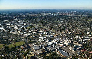
Blacktown is a suburb in the City of Blacktown local government area, in the state of New South Wales, Australia. Blacktown is located 34 km (21 mi) west of the Sydney central business district. It is one of the most multicultural places within Greater Sydney.
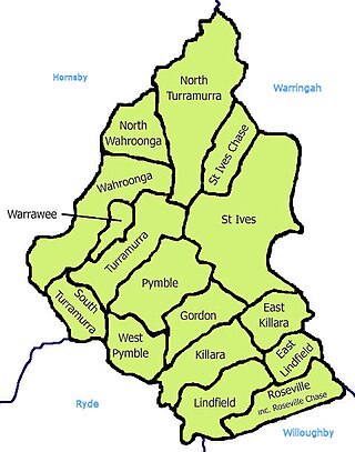
St Ives is a suburb on the Upper North Shore of Sydney in the state of New South Wales, Australia 18 kilometres north of the Sydney Central Business District in the local government area of Ku-ring-gai Council. St Ives Chase is a separate adjacent area, designated suburb, to the west and north.

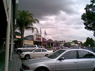
Quakers Hill is a suburb of Sydney, in the state of New South Wales, Australia. It is 40 kilometres (25 mi) westnorth-west (WNW) of the Sydney central business district, in the local government area of the City of Blacktown. Quakers Hill is part of the Greater Western Sydney region. Quakers Hill is colloquially known as 'Quakers'.

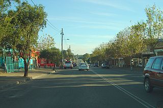
Rooty Hill is a suburb of Sydney, in the state of New South Wales, Australia. Rooty Hill is located 42 kilometres west of the Sydney central business district, in the local government area of the City of Blacktown and is part of the Greater Western Sydney region.

Toongabbie is a suburb of Sydney, in the state of New South Wales, Australia. One of the oldest suburbs in Sydney, Toongabbie is located approximately 30 kilometres west of the Sydney central business district and is part of the Greater Western Sydney region. Toongabbie is split between the local government areas of the City of Parramatta, the City of Blacktown and Cumberland Council. The suburb is often locally referred to as "Toonie".

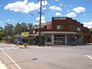
Acacia Gardens is a suburb of Sydney, in the state of New South Wales, Australia, 40 kilometres north-west of the Sydney central business district, in the local government area of the City of Blacktown. Acacia Gardens is part of the Greater Western Sydney region.

Oakhurst is a suburb of Sydney, in the state of New South Wales, Australia 46 kilometres west of the Sydney central business district, in the local government area of the City of Blacktown. It is part of the Greater Western Sydney region.

Dharruk is a suburb of Sydney, in the state of New South Wales, Australia. It is located 46 kilometres west of the Sydney central business district, in the local government area of the City of Blacktown and is part of the Greater Western Sydney region.

Emerton is a suburb of Sydney, in the state of New South Wales, Australia. Emerton is located 46 kilometres west of the Sydney central business district, in the local government area of the City of Blacktown and is part of the Greater Western Sydney region.

Glendenning is a suburb of Sydney, in the state of New South Wales, Australia. Glendenning is located 44 kilometres west of the Sydney central business district, in the local government area of the City of Blacktown and is part of the Greater Western Sydney region.

Hebersham is a suburb of Sydney, in the state of New South Wales, Australia. Hebersham is located 47 kilometres west of the Sydney central business district, in the local government area of the City of Blacktown and is part of the Greater Western Sydney region.
Kings Langley is a suburb of Sydney, in the state of New South Wales, Australia. Kings Langley is located 28.3 kilometres north-west in a straight line from the Sydney central business district in the local government area of Blacktown City council.

Lalor Park is a suburb of Sydney, in the state of New South Wales, Australia. Lalor Park is located 35 kilometres west of the Sydney central business district in the local government area of the City of Blacktown. Lalor Park is part of the Greater Western Sydney region. Lalor Park is commonly abbreviated as 'L.P'.
Marsden Park is a suburb of Sydney, in the state of New South Wales, Australia. Marsden Park is located 49 kilometres (30 mi) north-west of the Sydney central business district, in the Blacktown local government area and is part of the Greater Western Sydney region.
Riverstone is a suburb of Sydney in the state of New South Wales, Australia. Riverstone is located 48 kilometres (30 mi) north-west of the Sydney central business district, in the Blacktown local government area and part of the Greater Western Sydney region. Originally settled in 1803 as part of a government stock farm, Riverstone is one of the oldest towns in Australia.
Schofields is a suburb on the fringe of Sydney's urban sprawl, in the state of New South Wales, Australia. Schofields is located 45 kilometres (28 mi) north-west of the Sydney central business district, in the Blacktown local government area. It is part of Greater Western Sydney's North West Growth Area.
Cobbitty is a semi-rural town of the Macarthur Region near the town of Camden, southwest of Sydney, in the state of New South Wales, Australia. The area is mostly farmland with a population of just over 4,000.

The Ponds is a suburb of Sydney, in the state of New South Wales, Australia. The Ponds is about 40 kilometres (25 mi) west-northwest of the Sydney central business district in the Blacktown local government area. The 2016 census recorded the resident population of The Ponds as 11,731.

Thomas Hassall was an Anglican clergyman and the first Australian candidate for ordination. Hassall opened the first Sunday School in Australia in 1813 in his father's house at Parramatta.
Rowland Hassall, born in England, was a missionary in Tahiti for a short period of time and in New South Wales for the rest of his life. Initially a field preacher, he became a minister. He raised sheep, was a businessman, and became a prosperous land-owner. His son Thomas Hassall established the first Sunday school in Australia, after which Rowland Hassall co-founded the New South Wales Sunday School Institution in 1815.


