Emerton, New South Wales

Last updated

Emerton
Sydney,  New South Wales
EmertonNSWpool.jpg
Emerton Leisure Centre
Emerton, New South Wales
Map
Population2,252 (2016 census) [1]
 • Density2,820/km2 (7,300/sq mi)
Postcode(s) 2770
Elevation46 m (151 ft)
Area0.8 km2 (0.3 sq mi)
Location46 km (29 mi) W of Sydney CBD
LGA(s) City of Blacktown
State electorate(s)
Federal division(s) Chifley
Suburbs around Emerton:
Lethbridge Park Bidwill Blackett
Tregear Emerton Dharruk
Whalan Whalan Whalan

Emerton is a suburb of Sydney, in the state of New South Wales, Australia. Emerton is located 46 kilometres west of the Sydney central business district, in the local government area of the City of Blacktown and is part of the Greater Western Sydney region.

Contents

Emerton is primarily a residential suburb with very limited commercial activity centred on the Emerton Leisure Centre. It is quite close to the suburbs of Mount Druitt, New South Wales and St Marys.

The suburb's boundary is formed to the south and east by Popondetta Road continuing north around the extent of Popondetta Park. To the west, the boundary runs along Halmahera Creek until the creek meets Luxford Road and follows the road south to the intersection with Popondetta Road. [2]

History

Emerton takes its name from William Frederick Emert, a native of Siglingen, Germany, who arrived in Australia in 1853. In 1861 he became a storekeeper and postmaster in Mount Druitt. Emert also took a leading part in forming the Wesleyan Church in Australia.

Commercial areas

There are several retail developments adjacent to the intersection of Jersey and Popondetta Roads, surrounding the main shopping centre called 'Emerton Village'. These include an Australia Post post office, supermarket, service station, medical centres, take-away food and a hotel. Banking is limited to retail EFTPOS and automatic teller machines.

Transport

By road Emerton is adjacent to the Westlink M7 motorway which can provide very easy access to the Great Western Highway and the M4 Motorway, providing road access to the western sections of the city and eastward to the Sydney CBD. This suburb is linked by several private bus companies to the train stations located at Mount Druitt and St Marys.

Cycleways running through Emerton run from Popondetta Park all the way to Mt Druitt and the M7 cycleway, which in turn connects to the cycleways on the M4 and M2 motorways.

Housing

The three most common forms of dwelling were in decreasing order: a separate house; a semi-detached, row/terrace house, or townhouse; a flat, unit or apartment. [1]

Recreation

Following extensive refurbishment by Blacktown City Council, the Emerton Leisure Centre (formerly Emerton Pool) was reopened in August 2006. [3] In 2017, the centre was renamed the Charlie Lowles Leisure Centre. The leisure centre incorporates both indoor and outdoor swimming pools (including a hydrotherapy pool) and outdoor facilities include a beach volleyball court.

Adjacent is Popondetta Park, which extends between Popondetta Road and Halamahera Creek, from Jersey Road to Bougainville Road. This park incorporates extensive sporting fields for cricket, netball, rugby league and soccer.

Population

According to the 2016 census of Population, there were 2,252 people in Emerton.

Politics

For federal elections, Emerton is in the safe Labor electoral division of Chifley. This seat is currently held by Ed Husic of the Labor Party, elected in the 2010 election. He was Australia's first Muslim in the federal government during Kevin Rudd's second stint as prime minister. Chifley has been held continuously by Labor since it was proclaimed in 1984.

For NSW state elections, Emerton is mainly in the Electoral district of Londonderry. It is represented by Prue Car of the Labor Party.

Related Research Articles

<span class="mw-page-title-main">Greater Western Sydney</span> Region in New South Wales, Australia

Greater Western Sydney (GWS) is a large region of the metropolitan area of Greater Sydney, New South Wales (NSW), Australia that generally embraces the north-west, south-west, central-west, far western and the Blue Mountains sub-regions within Sydney's metropolitan area and encompasses 13 local government areas: Blacktown, Blue Mountains, Camden, Campbelltown, Canterbury-Bankstown, Cumberland, Fairfield, Hawkesbury, Hills Shire, Liverpool, Parramatta, Penrith and Wollondilly. It includes Western Sydney, which has a number of different definitions, although the one consistently used is the region composed of ten local government authorities, most of which are members of the Western Sydney Regional Organisation of Councils (WSROC). Penrith, Hills Shire & Canterbury-Bankstown are not WSROC members. The NSW Government's Office of Western Sydney calls the region "Greater Western Sydney".

<span class="mw-page-title-main">Westlink M7</span> Motorway in Sydney, Australia

The Westlink M7 is a 40-kilometre (25 mi) tolled urban motorway in Sydney, New South Wales that is part of the Sydney Orbital Network. Owned by the NorthWestern Roads (NWR) Group, it connects three motorways: the M5 South-West Motorway at Prestons, the M4 Western Motorway at Eastern Creek, and the M2 Hills Motorway at Baulkham Hills.

<span class="mw-page-title-main">Division of Chifley</span> Australian federal electoral division

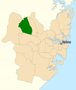
The Division of Chifley is an Australian electoral division in the state of New South Wales.

<span class="mw-page-title-main">Rooty Hill, New South Wales</span> Suburb of Sydney, New South Wales, Australia

Rooty Hill is a suburb of Sydney, in the state of New South Wales, Australia. Rooty Hill is located 42 kilometres west of the Sydney central business district, in the local government area of the City of Blacktown and is part of the Greater Western Sydney region.

<span class="mw-page-title-main">Mount Druitt</span> Suburb of Sydney, New South Wales, Australia

Mount Druitt is a suburb of Sydney, in the state of New South Wales, Australia. It is located 43 kilometres (27 mi) west of the Sydney central business district, in the local government area of the City of Blacktown, and is part of the Greater Western Sydney region.

<span class="mw-page-title-main">Bidwill, New South Wales</span> Suburb of Sydney, New South Wales, Australia

Bidwill is a suburb of Sydney, in the state of New South Wales, Australia. Bidwill is located 48 kilometres west of the Sydney central business district, in the local government area of the City of Blacktown and is part of the Greater Western Sydney region.

<span class="mw-page-title-main">Blackett, New South Wales</span> Suburb of Sydney, New South Wales, Australia

Blackett is a suburb of Sydney, in the state of New South Wales, Australia. Blackett is located 48 kilometres west of the Sydney central business district, in the local government area of the City of Blacktown and is part of the Greater Western Sydney region.

<span class="mw-page-title-main">Dharruk, New South Wales</span> Suburb of Sydney, New South Wales, Australia

Dharruk is a suburb of Sydney, in the state of New South Wales, Australia. It is located 46 kilometres west of the Sydney central business district, in the local government area of the City of Blacktown and is part of the Greater Western Sydney region.

<span class="mw-page-title-main">Huntingwood, New South Wales</span> Suburb of Sydney, New South Wales, Australia

Huntingwood is a predominantly industrial suburb in the City of Blacktown, in Western Sydney, in the state of New South Wales, Australia.

<span class="mw-page-title-main">Plumpton, New South Wales</span> Suburb of Sydney, New South Wales, Australia

Plumpton is located 45 kilometres west of the Sydney central business district, in the local government area of the City of Blacktown and is part of the Greater Western Sydney region.

<span class="mw-page-title-main">Shalvey, New South Wales</span> Suburb of Sydney, New South Wales, Australia

Shalvey is a suburb of Blacktown, in the state of New South Wales, Australia. Shalvey is located 48 kilometres west of the Sydney central business district, in the local government area of the City of Blacktown and is part of the Greater Western Sydney region.

<span class="mw-page-title-main">Woodcroft, New South Wales</span> Suburb of Sydney, New South Wales, Australia

Woodcroft is a suburb of Sydney, in the state of New South Wales, Australia. Woodcroft is located 37 kilometres west of the Sydney central business district, in the local government area of the City of Blacktown and is part of the Greater Western Sydney region. Woodcroft Lake is on Bricketwood Drive and the Neighbourhood Centre is beside it. It is popular among the community. The suburb contains many play areas.

<span class="mw-page-title-main">Norwest Business Park</span>

The Norwest Business Park is a business park in the suburbs of Norwest and Bella Vista in the local government area of The Hills Shire in Sydney, New South Wales, Australia. Norwest Business Park is bordered by Windsor Road to the east, and Old Windsor Road to the west, with Norwest Boulevard stretching the length of the park between the two main arterial roads. Over 400 companies are located in the park, employing more than 25,000 people. The complex consists of a mix of commercial, professional and health-care services provided to the population of Sydney's Hills District.

<span class="mw-page-title-main">The Ponds, New South Wales</span> Suburb of Sydney, New South Wales, Australia

The Ponds is a suburb of Sydney, in the state of New South Wales, Australia. The Ponds is located approximately 40 kilometres (25 mi) west-northwest (WNW) of the Sydney central business district in the Blacktown local government area. At the 2016 census, The Ponds had an estimated resident population of 11,731.

Ropes Creek, a watercourse that is part of the Hawkesbury-Nepean catchment, is located in Greater Western Sydney, New South Wales, Australia.

Bungarribee is a suburb of Blacktown, in the state of New South Wales, Australia. Bungarribee is located approximately 37 kilometres west of the Sydney central business district, in the local government area of the City of Blacktown and is part of the Greater Western Sydney region.

<span class="mw-page-title-main">Western Sydney Parklands</span>

The Western Sydney Parklands is an urban park system and a nature reserve located in Sydney, New South Wales, Australia. The NSW government has spent around $400 million for the park. The park is governed by the NSW National Parks and Wildlife Service and is listed under the National Parks and Wildlife Act 1974. The Parklands begin in the north in the City of Blacktown, cross the City of Fairfield, and end in the City of Liverpool.

<span class="mw-page-title-main">Toongabbie Creek</span> River in New South Wales, Australia

Toongabbie Creek, an urban watercourse that is part of the Parramatta River catchment, is located in Greater Western Sydney, New South Wales, Australia.

The M7 cycleway is a 40-kilometre-long (25 mi) shared use path for cyclists and pedestrians that is generally aligned with the Westlink M7 in Greater Western Sydney, New South Wales, Australia. The southern terminus of the cycleway is located adjacent to the Camden Valley Way at Prestons, while the northern terminus is located adjacent to the Old Windsor Road at Glenwood. The cycleway crosses the M4 motorway at Eastern Creek.

Caddens is a suburb of Sydney, in the state of New South Wales in Australia. It is a new masterplanned residential neighborhood located 48 kilometres west of the Sydney central business district, in the local government area of the City of Penrith featuring views of the scenic Blue Mountains. The suburb's postcode is 2747.

References

  1. 1 2 3 Australian Bureau of Statistics (27 June 2017). "Emerton (State Suburb)". 2016 Census QuickStats. Retrieved 17 January 2019. OOjs UI icon edit-ltr-progressive.svg CC-BY icon.svg Material was copied from this source, which is available under a Creative Commons Attribution 4.0 International License.
  2. "Emerton". Geographical Names Register (GNR) of NSW. Geographical Names Board of New South Wales . Retrieved 5 August 2013. OOjs UI icon edit-ltr-progressive.svg
  3. Public Relations, Blacktown City Council (2006). "Over 6000 people enjoy the FREE community weekend at the new Emerton Leisure Centre". City of Blacktown. Archived from the original on 3 September 2007. Retrieved 19 October 2006.

33°45′0″S150°48′10″E / 33.75000°S 150.80278°E / -33.75000; 150.80278