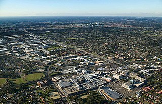
Blacktown is a suburb in the City of Blacktown local government area, in the state of New South Wales, Australia. Blacktown is located 34 km (21 mi) west of the Sydney central business district. It is one of the most multicultural places within Greater Sydney.

Doonside is a suburb in the metropolis of Sydney, in the state of New South Wales, Australia. Doonside is located 40 kilometres west of the Sydney central business district, in the local government area of the City of Blacktown and is part of the Greater Western Sydney region. Featherdale Wildlife Park and the Nurragingy Nature Reserve are popular local tourist attractions.

Greater Western Sydney (GWS) is a large region of the metropolitan area of Greater Sydney, New South Wales (NSW), Australia that generally embraces the north-west, south-west, central-west, far western and the Blue Mountains sub-regions within Sydney's metropolitan area and encompasses 11 local government areas: Blacktown, Blue Mountains, Camden, Campbelltown, Cumberland, Fairfield, Hawkesbury, Liverpool, Parramatta, Penrith and Wollondilly. It includes Western Sydney, which has a number of different definitions, although the one consistently used is the region composed of ten local government authorities, most of which are members of the Western Sydney Regional Organisation of Councils (WSROC). The NSW Government's Office of Western Sydney calls the region "Greater Western Sydney".

Quakers Hill is a suburb of Sydney, in the state of New South Wales, Australia. It is 40 kilometres (25 mi) westnorth-west (WNW) of the Sydney central business district, in the local government area of the City of Blacktown. Quakers Hill is part of the Greater Western Sydney region. Quakers Hill is colloquially known as 'Quakers'.

Seven Hills is a suburb in the Greater Western Sydney region of Sydney, in the state of New South Wales, Australia, located 33 kilometres North West of the Sydney central business district. Seven Hills is within the local government areas of the City of Parramatta and Blacktown City councils.

The South Creek or Wianamatta is a creek that is part of the Hawkesbury-Nepean catchment, located on the Cumberland Plain in Greater Western Sydney, New South Wales, Australia.

Mount Druitt is a suburb of Sydney, in the state of New South Wales, Australia. It is located 43 kilometres (27 mi) west of the Sydney central business district, in the local government area of the City of Blacktown, and is part of the Greater Western Sydney region.
Kings Langley is a suburb of Sydney, in the state of New South Wales, Australia. Kings Langley is located 28.3 kilometres north-west in a straight line from the Sydney central business district in the local government area of Blacktown City council.
Marsden Park is a suburb of Sydney, in the state of New South Wales, Australia. Marsden Park is located 49 kilometres (30 mi) north-west of the Sydney central business district, in the Blacktown local government area and is part of the Greater Western Sydney region.
Riverstone is a suburb of Sydney in the state of New South Wales, Australia. Riverstone is located 48 kilometres (30 mi) north-west of the Sydney central business district, in the Blacktown local government area and part of the Greater Western Sydney region. Originally settled in 1803 as part of a government stock farm, Riverstone is one of the oldest towns in Australia.
Schofields is a suburb on the fringe of Sydney's urban sprawl, in the state of New South Wales, Australia. Schofields is located 45 kilometres (28 mi) north-west of the Sydney central business district, in the Blacktown local government area. It is part of Greater Western Sydney's North West Growth Area.
Stanhope Gardens is a suburb of Greater Western Sydney, in the state of New South Wales, Australia. Stanhope Gardens is located 31 kilometres north-west of the Sydney central business district in the local government area of City of Blacktown.
Beaumont Hills is a suburb of Sydney, in the state of New South Wales, Australia 40 kilometres north west of the Sydney central business district, in the local government area of The Hills Shire. Beaumont Hills is part of the Greater Western Sydney region and the Hills District.

The Ponds is a suburb of Sydney, in the state of New South Wales, Australia. The Ponds is about 40 kilometres (25 mi) west-northwest of the Sydney central business district in the Blacktown local government area. The 2016 census recorded the resident population of The Ponds as 11,731.
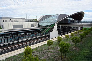
Tallawong railway station is a Sydney Metro station near the intersection of Cudgegong and Schofield Roads in Tallawong, New South Wales, Australia. The station is the terminus of the Metro North West & Bankstown Line on the Sydney Metro network. Beyond the station to the west lies the Tallawong depot, where metro rolling stock is stabled.
Nirimba Fields is a suburb of Sydney in the state of New South Wales, Australia. Nirimba Fields is in north-west Sydney in the local government area of Blacktown. Nirimba is a Dharug word meaning pelican.
Tallawong is a suburb of Sydney in the state of New South Wales, Australia. Tallawong is in north-west Greater Sydney Area in the local government area of Blacktown. It is named after the metro station located within its boundaries, which opened in May 2019. Tallawong is a Darug word meaning apple gum tree.
Angus is a suburb of Sydney in the state of New South Wales, Australia. Angus is north-west of Sydney City in the local government area of Blacktown.
Richards is a suburb of Sydney, in the state of New South Wales, Australia. Richards is located north-west of Sydney City in the local government area of Blacktown.
Melonba is a suburb of Blacktown, in the state of New South Wales, Australia. Melonba is located approximately 51 kilometres (32 mi) north-west of Sydney City in the local government area of Blacktown.

