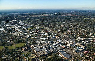
Blacktown is a suburb in the City of Blacktown local government area, in the state of New South Wales, Australia. Blacktown is located 34 km (21 mi) west of the Sydney central business district. It is one of the most multicultural places within Greater Sydney.

Doonside is a suburb in the metropolis of Sydney, in the state of New South Wales, Australia. Doonside is located 40 kilometres west of the Sydney central business district, in the local government area of the City of Blacktown and is part of the Greater Western Sydney region. Featherdale Wildlife Park and the Nurragingy Nature Reserve are popular local tourist attractions.

Westmead is a suburb in Sydney, in the state of New South Wales, Australia. Westmead is located 26 kilometres west of the Sydney central business district in the local government areas of City of Parramatta and Cumberland Council and is part of the Greater Western Sydney region.
Marayong is a suburb of Sydney, in the state of New South Wales, Australia. Marayong is located approximately 32 kilometres north west of the Sydney central business district, in the local government area of the City of Blacktown and is part of the Greater Western Sydney region.

Quakers Hill is a suburb of Sydney, in the state of New South Wales, Australia. It is 40 kilometres (25 mi) westnorth-west (WNW) of the Sydney central business district, in the local government area of the City of Blacktown. Quakers Hill is part of the Greater Western Sydney region. Quakers Hill is colloquially known as 'Quakers'.

Rooty Hill is a suburb of Sydney, in the state of New South Wales, Australia. Rooty Hill is located 42 kilometres west of the Sydney central business district, in the local government area of the City of Blacktown and is part of the Greater Western Sydney region.

Bella Vista is located 33 kilometres north-west of the Sydney central business district and is part of The Hills Shire. It is a suburb in the Hills District of Greater Western Sydney and is in the state of New South Wales, Australia. Bella Vista's Norwest Business Park is home to several Fortune 500 companies, a number of shopping centres, high-rise buildings, and industrial and recreational spaces.

The Division of Greenway is an Australian electoral division in the state of New South Wales.
Kingswood is a suburb in western Sydney, in the state of New South Wales in Australia. It is 52 kilometres west of the Sydney central business district, in the local government area of the City of Penrith. There are various other locations within the state of New South Wales that are also called Kingswood, and is often confused with the nearby suburb of Kingswood Park.

Bidwill is a suburb of Sydney, in the state of New South Wales, Australia. Bidwill is located 48 kilometres west of the Sydney central business district, in the local government area of the City of Blacktown and is part of the Greater Western Sydney region.

Blackett is a suburb of Sydney, in the state of New South Wales, Australia. Blackett is located 48 kilometres west of the Sydney central business district, in the local government area of the City of Blacktown and is part of the Greater Western Sydney region.

Dharruk is a suburb of Sydney, in the state of New South Wales, Australia. It is located 46 kilometres west of the Sydney central business district, in the local government area of the City of Blacktown and is part of the Greater Western Sydney region.
Glenwood is a suburb of Sydney, in the state of New South Wales, Australia. Glenwood is located 33 kilometres north-west of the Sydney central business district in the local government area of the City of Blacktown and part of the Greater Western Sydney region.

Kellyville Ridge is a suburb of Sydney, in the state of New South Wales, Australia. Kellyville Ridge is located 41 kilometres north-west of the Sydney central business district in the local government area of City of Blacktown. It is part of Greater Western Sydney.
Kings Langley is a suburb of Sydney, in the state of New South Wales, Australia. Kings Langley is located 28.3 kilometres north-west in a straight line from the Sydney central business district in the local government area of Blacktown City council.

Kings Park is a suburb of Sydney, in the state of New South Wales, Australia. Kings Park is located 40 km west of the Sydney central business district, in the local government area of the City of Blacktown and part of the Greater Western Sydney region.
Riverstone is a suburb of Sydney in the state of New South Wales, Australia. Riverstone is located 48 kilometres (30 mi) north-west of the Sydney central business district, in the Blacktown local government area and part of the Greater Western Sydney region. Originally settled in 1803 as part of a government stock farm, Riverstone is one of the oldest towns in Australia.
Stanhope Gardens is a suburb of Greater Western Sydney, in the state of New South Wales, Australia. Stanhope Gardens is located 31 kilometres north-west of the Sydney central business district in the local government area of City of Blacktown.

The Ponds is a suburb of Sydney, in the state of New South Wales, Australia. The Ponds is about 40 kilometres (25 mi) west-northwest of the Sydney central business district in the Blacktown local government area. The 2016 census recorded the resident population of The Ponds as 11,731.
Caddens is a suburb of Sydney, in the state of New South Wales in Australia. It is a new masterplanned residential neighborhood located 48 kilometres west of the Sydney central business district, in the local government area of the City of Penrith featuring views of the scenic Blue Mountains. The suburb's postcode is 2747.

