
Castle Hill is a town in Sydney, New South Wales, Australia, located 34 kilometres north-west of the Sydney central business district and 9.5 kilometres north of Parramatta. It is within the Hills District region, split between the local government areas of The Hills Shire and Hornsby Shire.

Girraween is a suburb of Sydney, in the state of New South Wales, Australia. Girraween is located 30 km west of the Sydney central business district, in the local government area of Cumberland Council and is part of the Greater Western Sydney region.
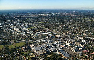
Blacktown is a city in the City of Blacktown local government area, in the state of New South Wales, Australia. Blacktown is located 34 km (21 mi) west of the Sydney central business district. It is one of the most multicultural places within Greater Sydney.

Greater Western Sydney (GWS) is a large region of the metropolitan area of Greater Sydney, New South Wales (NSW), Australia that generally embraces the north-west, south-west, central-west, far western and the Blue Mountains sub-regions within Sydney's metropolitan area and encompasses 11 local government areas: Blacktown, Blue Mountains, Camden, Campbelltown, Cumberland, Fairfield, Hawkesbury, Liverpool, Parramatta, Penrith and Wollondilly. It includes Western Sydney, which has a number of different definitions, although the one consistently used is the region composed of ten local government authorities, most of which are members of the Western Sydney Regional Organisation of Councils (WSROC). The NSW Government's Office of Western Sydney calls the region "Greater Western Sydney".

North Epping is a suburb of Sydney, in the state of New South Wales, Australia 19 kilometres north-west of the Sydney central business district in the local government area of Hornsby Shire. North Epping is in the Northern Sydney region, and is often referred to as part of the "North-West" or North Shore. Epping is a separate suburb to the south and under the Parramatta City Council, which shares the postcode of 2121.

The City of Hawkesbury is a local government area of New South Wales, Australia, located on the northern and north-western fringe of the Greater Sydney area, about 50 kilometres (31 mi) north-west of the Sydney central business district. Hawkesbury City is named after the Hawkesbury River. Major towns in City of Hawkesbury are Windsor, Richmond and Pitt Town.

The South Creek or Wianamatta is a creek that is part of the Hawkesbury-Nepean catchment, located on the Cumberland Plain in Greater Western Sydney, New South Wales, Australia.

Yowie Bay is a suburb in southern Sydney, in the state of New South Wales, Australia. Yowie Bay is located 24 kilometres south of the Sydney central business district, in the local government area of the Sutherland Shire.

Dharruk is a suburb of Sydney, in the state of New South Wales, Australia. It is located 46 kilometres west of the Sydney central business district, in the local government area of the City of Blacktown and is part of the Greater Western Sydney region.
Marsden Park is a suburb of Sydney, in the state of New South Wales, Australia. Marsden Park is located 49 kilometres (30 mi) north-west of the Sydney central business district, in the Blacktown local government area and is part of the Greater Western Sydney region.
Riverstone is a suburb of Sydney in the state of New South Wales, Australia. Riverstone is located 48 kilometres (30 mi) north-west of the Sydney central business district, in the Blacktown local government area and part of the Greater Western Sydney region. Originally settled in 1803 as part of a government stock farm, Riverstone is one of the oldest towns in Australia.

Willmot is a suburb of Sydney, in the state of New South Wales, Australia 49 kilometres west of the Sydney central business district, in the local government area of the City of Blacktown and is part of the Greater Western Sydney region.

Blacktown City Council is a local government area in Western Sydney, situated on the Cumberland Plain, approximately 35 kilometres (22 mi) west of the Sydney central business district, in the state of New South Wales, Australia. Established in 1906 as the Blacktown Shire and becoming the Municipality of Blacktown in 1961 before gaining city status in 1979, the City occupies an area of 246.9 square kilometres (95.3 sq mi) and has a population of 410,419, making it the most populous local government area in Sydney.
Middle Dural is a semi-rural suburb of Sydney, in the state of New South Wales, Australia, 37 kilometres (23 mi) north-west of the Sydney central business district in the local government areas of Hornsby Shire and The Hills Shire. Dural is a separate suburb to the south.

The metropolis of Greater Sydney in New South Wales, Australia, is informally subdivided into a number of geographic regions. The geographical definition of Greater Sydney spans across 33 local government areas and includes the Blue Mountains in the west, the Northern Beaches and the Hawkesbury in the north, the Royal National Park, the Wollondilly and Macarthur in the south, and Botany Bay in the east. These areas sometimes, but not always, roughly coincide with official boundaries of suburbs, local government authorities, or cadastral units, and some of the customary regions do not have well defined boundaries at all. Some commonly referred to regions overlap: for example, Canterbury-Bankstown is often referred to as a region, but it is also part of the South Western Sydney region. The regions themselves are not used as a formal jurisdiction, and generally do not have administrative or legislative bodies, although some regions are coterminous with a local government area, and in a number of regions that include multiple local government areas, Regional Organisations of Councils have been established that represent the councils in the region.
Nirimba Fields is a suburb of Sydney in the state of New South Wales, Australia. Nirimba Fields is in north-west Sydney in the local government area of Blacktown. Nirimba is a Dharug word meaning pelican.
Tallawong is a suburb of Blacktown in the state of New South Wales, Australia. Tallawong is in north-west Greater Sydney Area in the local government area of Blacktown. It is named after the metro station located within its boundaries, which opened in May 2019. Tallawong is a Darug word meaning apple gum tree.
Grantham Farm is a suburb of Sydney, in the state of New South Wales, Australia. Grantham Farm is located in north-west Sydney in the local government area of Blacktown.
Richards is a suburb of Sydney, in the state of New South Wales, Australia. Richards is located north-west of Sydney City in the local government area of Blacktown.
Melonba is a suburb of Blacktown, in the state of New South Wales, Australia. Melonba is located approximately 51 kilometres (32 mi) north-west of Sydney City in the local government area of Blacktown.

