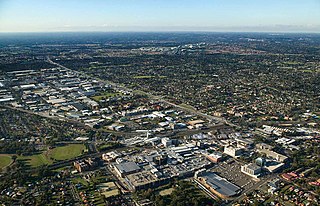
Blacktown is a suburb in the City of Blacktown local government area, in the state of New South Wales, Australia. Blacktown is located 34 km (21 mi) west of the Sydney central business district. It is one of the most multicultural places within Greater Sydney.

Doonside is a suburb in the metropolis of Sydney, in the state of New South Wales, Australia. Doonside is located 40 kilometres west of the Sydney central business district, in the local government area of the City of Blacktown and is part of the Greater Western Sydney region. Featherdale Wildlife Park and the Nurragingy Nature Reserve are popular local tourist attractions.

The Westlink M7 is a 40-kilometre (25 mi) tolled urban motorway in Sydney, New South Wales that is part of the Sydney Orbital Network. Owned by the NorthWestern Roads (NWR) Group, it connects three motorways: the M5 South-West Motorway at Prestons, the M4 Western Motorway at Eastern Creek, and the M2 Hills Motorway at Baulkham Hills.
Marayong is a suburb of Sydney, in the state of New South Wales, Australia. Marayong is located approximately 32 kilometres north west of the Sydney central business district, in the local government area of the City of Blacktown and is part of the Greater Western Sydney region.

Rooty Hill is a suburb of Sydney, in the state of New South Wales, Australia. Rooty Hill is located 42 kilometres west of the Sydney central business district, in the local government area of the City of Blacktown and is part of the Greater Western Sydney region.

Mount Druitt railway station is located on the Main Western line, serving the Sydney suburb of Mount Druitt. It is served by Sydney Trains T1 Western line services.

Blacktown railway station is located on the Main Western line, serving the Sydney suburb of Blacktown. It is served by Sydney Trains T1 Western Line and T5 Cumberland Line services and NSW TrainLink Intercity Blue Mountains Line and regional Central West XPT services.

Bidwill is a suburb of Sydney, in the state of New South Wales, Australia. Bidwill is located 48 kilometres west of the Sydney central business district, in the local government area of the City of Blacktown and is part of the Greater Western Sydney region.

Blackett is a suburb of Sydney, in the state of New South Wales, Australia. Blackett is located 48 kilometres west of the Sydney central business district, in the local government area of the City of Blacktown and is part of the Greater Western Sydney region.

Dharruk is a suburb of Sydney, in the state of New South Wales, Australia. It is located 46 kilometres west of the Sydney central business district, in the local government area of the City of Blacktown and is part of the Greater Western Sydney region.

Emerton is a suburb of Sydney, in the state of New South Wales, Australia. Emerton is located 46 kilometres west of the Sydney central business district, in the local government area of the City of Blacktown and is part of the Greater Western Sydney region.
Glenwood is a suburb of Sydney, in the state of New South Wales, Australia. Glenwood is located 33 kilometres north-west of the Sydney central business district in the local government area of the City of Blacktown and part of the Greater Western Sydney region.
Kings Langley is a suburb of Sydney, in the state of New South Wales, Australia. Kings Langley is located 28.3 kilometres north-west in a straight line from the Sydney central business district in the local government area of Blacktown City council.

Kings Park is a suburb of Sydney, in the state of New South Wales, Australia. Kings Park is located 40 km west of the Sydney central business district, in the local government area of the City of Blacktown and part of the Greater Western Sydney region.
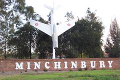
Minchinbury is a small suburb in western Sydney, in the state of New South Wales, Australia. Minchinbury is located 38 kilometres (24 mi) west of the Sydney central business district, in Blacktown local government area and is part of the Greater Western Sydney region.

Erskine Park is a suburb of Sydney in the state of New South Wales, Australia. Erskine Park is located 42 kilometres west of the Sydney central business district, in the local government area of the City of Penrith and is part of the Greater Western Sydney region.

The Ponds is a suburb of Sydney, in the state of New South Wales, Australia. The Ponds is about 40 kilometres (25 mi) west-northwest (WNW) of the Sydney central business district in the Blacktown local government area. The 2016 census recorded the resident population of The Ponds as 11,731.
Bells Creek, an urban watercourse that is part of the Hawkesbury-Nepean catchment, is located in Greater Western Sydney, New South Wales, Australia.
Caddens is a suburb of Sydney, in the state of New South Wales in Australia. It is a new masterplanned residential neighborhood located 48 kilometres west of the Sydney central business district, in the local government area of the City of Penrith featuring views of the scenic Blue Mountains. The suburb's postcode is 2747.

Imperial Hotel is a heritage-listed Australian pub at 1 Rooty Hill Road North, Rooty Hill, City of Blacktown, Sydney, New South Wales, Australia. The property is owned by Dyemist Pty Ltd. It was added to the New South Wales State Heritage Register on 2 April 1999.


