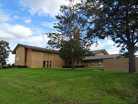
Girraween is a suburb of Sydney, in the state of New South Wales, Australia. Girraween is located 30 km west of the Sydney central business district, in the local government area of Cumberland Council and is part of the Greater Western Sydney region.
Kingswood is a suburb in western Sydney, in the state of New South Wales in Australia. It is 52 kilometres west of the Sydney central business district, in the local government area of the City of Penrith. There are various other locations within the state of New South Wales that are also called Kingswood, and is often confused with the nearby suburb of Kingswood Park.

Bidwill is a suburb of Sydney, in the state of New South Wales, Australia. Bidwill is located 48 kilometres west of the Sydney central business district, in the local government area of the City of Blacktown and is part of the Greater Western Sydney region.

Blackett is a suburb of Sydney, in the state of New South Wales, Australia. Blackett is located 48 kilometres west of the Sydney central business district, in the local government area of the City of Blacktown and is part of the Greater Western Sydney region.

Dean Park is a suburb of Sydney, in the state of New South Wales, Australia. Dean Park is located 43 kilometres west of the Sydney central business district, in the local government area of the City of Blacktown and is part of the Western Sydney region.

Dharruk is a suburb of Sydney, in the state of New South Wales, Australia. It is located 46 kilometres west of the Sydney central business district, in the local government area of the City of Blacktown and is part of the Greater Western Sydney region.

Emerton is a suburb of Sydney, in the state of New South Wales, Australia. Emerton is located 46 kilometres west of the Sydney central business district, in the local government area of the City of Blacktown and is part of the Greater Western Sydney region.

Kings Park is a suburb of Sydney, in the state of New South Wales, Australia. Kings Park is located 40 km west of the Sydney central business district, in the local government area of the City of Blacktown and part of the Greater Western Sydney region.

Lalor Park is a suburb of Sydney, in the state of New South Wales, Australia. Lalor Park is located 35 kilometres west of the Sydney central business district in the local government area of the City of Blacktown. Lalor Park is part of the Greater Western Sydney region. Lalor Park is commonly abbreviated as 'L.P'.

Whalan is a suburb of Sydney, in the state of New South Wales, Australia. Whalan is located 45 kilometres west of the Sydney central business district, in the local government area of the City of Blacktown and is part of the Greater Western Sydney region.
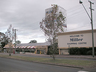
Miller is a suburb of Sydney in the state of New South Wales, Australia 38 kilometres south-west of the Sydney central business district, in the local government area of the City of Liverpool. Neighbouring suburbs include Hoxton Park, Hinchinbrook, Cartwright, Prestons, Sadleir and Busby.
Lurnea is a suburb of Sydney, in the state of New South Wales, Australia. It is 35 kilometres south-west of the Sydney central business district, in the local government area of the City of Liverpool.
Busby is a suburb of Sydney, in the state of New South Wales, Australia. Busby is located 37 kilometres south-west of the Sydney central business district, in the local government area of the City of Liverpool. Neighbouring suburbs include Miller, Heckenberg, Hinchinbrook, Green Valley and Bonnyrigg.

Cartwright is a suburb in south-western Sydney, in the state of New South Wales, Australia 38 kilometres south-west of the Sydney central business district, in the local government area of the City of Liverpool.
Catherine Field is a suburb of Sydney and part of the Macarthur Region in the state of New South Wales, Australia. Catherine Field is 43 kilometres south-west of the Sydney central business district, in the local government area of Camden Council.

Cattai is an historic suburb of Sydney, in the state of New South Wales, Australia. It is located 44 kilometres north-west of the Sydney central business district and 30 kilometres north-west of Parramatta. It is in the local government areas of The Hills Shire and City of Hawkesbury. Cattai's state electoral district is Hawkesbury, and its federal electoral divisions are Berowra and Macquarie.
Glossodia is a small town in the state of New South Wales, Australia. Glossodia is located 68 kilometres north-west of the Sydney central business district in the local government area of the City of Hawkesbury.

Guildford West is a suburb of Sydney, in the state of New South Wales, Australia that is located 26 kilometres west of the Sydney central business district, in the local government area of the Cumberland City Council and is part of the Greater Western Sydney region. Guildford West shares the postcode of 2161 with the separate suburbs of Guildford and Old Guildford.
Claremont Meadows is a suburb of Sydney, in the state of New South Wales, Australia. Claremont Meadows is located 45 kilometres west of the Sydney central business district, in the local government area of the City of Penrith and is part of the Greater Western Sydney region.

Colyton is a suburb of Sydney, in the state of New South Wales, Australia 43 kilometres west of the Sydney central business district, in the local government area of the City of Penrith. It is part of the Greater Western Sydney region.