Rooty Hill, New South Wales

Last updated

Rooty Hill
Sydney,  New South Wales
Rooty Hill, New South Wales.JPG
Rooty Hill, seen from the railway station. In the background is the hill from which the area gets its name.
Rooty Hill, New South Wales
Population16,176 (2021 census) [1]
 • Density2,568/km2 (6,650/sq mi)
Postcode(s) 2766
Elevation42 m (138 ft)
Area6.3 km2 (2.4 sq mi)
Location42 km (26 mi) west of Sydney CBD
LGA(s) City of Blacktown
State electorate(s) Mount Druitt
Federal division(s) Chifley
Suburbs around Rooty Hill:
Whalan Plumpton Glendenning
Mount Druitt Rooty Hill Doonside
Colyton Minchinbury Eastern Creek

Rooty Hill is a suburb of Sydney, in the state of New South Wales, Australia. Rooty Hill is located 42 kilometres west of the Sydney central business district, in the local government area of the City of Blacktown and is part of the Greater Western Sydney region.

Contents

History

Pre-colonial (Aboriginal) era

Rooty Hill was broadly inhabited by the Darug people before European settlement.

Colonial era

The earliest exploration of the area was led by Captain Watkin Tench in 1789. [2] The origin of this name puzzled historians for many years because the clue lay not in Blacktown City but on Norfolk Island. Governor Philip Gidley King had been in charge of the first settlement there in early 1788 and had noted that the hillside where he had built his Government House had been difficult to dig owing to the amount of tree roots beneath the surface. The hill on Norfolk became known as Rooty Hill and the name is now official. [3] When King returned to New South Wales he built the headquarters for his government reserve of 1802 at the foot of a hill that reminded him of the Norfolk Island Rooty Hill and used the same name. [4] The name Rooty Hill first appeared on a map in 1803.

The early development of the area came when Captain William Minchin was given a grant of 400 hectares (1,000 acres) in 1819, leading to the development of the Minchinbury estate. Dr Charles McKay purchased the estate in 1859 and subdivided it in the 1880s. Afterwards, the Watts family built Watts Cottage in Watt Street. It combines Italianate elements with a bullnose verandah and is almost unique in the Blacktown Municipality. It is locally heritage-listed. [5]

In 1890, the Imperial Hotel was built north of the railway station by F.J. Weston. It was intended to cater for the crowds who attended the greyhound racing at Lamb's Woodstock Coursing Track at Plumpton. By the early 1970s it had become semi-derelict, but was acquired by a local dentist in 1977. It reopened in 1982 and is now state heritage-listed. [6]

In 1891, the Pioneer Memorial Church, located on Rooty Hill Road South, was built on land donated by Dr Charles McKay. It was originally a Baptist church, but was later acquired for the Presbyterian community by James Angus, owner of the Minchinbury estate from 1895. It is still in use and is locally heritage-listed. [7]

Post federation

In 1902–1903, the School of Arts, located in Rooty Hill Road South, was built by the residents for community activities. The foundation stone was laid 1 November 1902, by Miss Angus, [8] daughter of James Angus. It is locally heritage-listed. [9]

On 13 April 1916, James Angus was killed at Rooty Hill railway crossing, as a result of being hit by that morning's express train. He was survived by his wife, his son James (of Adelaide), his son John (a pastoralist in New South Wales) and his daughter, who by that time was the widow Mrs Fleming. [10]

The name of James Angus is preserved in Angus Avenue; Charles McKay's name survives in Dr Charles McKay Reserve; the name of the Evans family, who built Fairholme, survives in Evans Road. Fairholme, now part of the St Agnes Catholic High School, is locally heritage-listed. [11]

Post war

During and following World War II, Australia had realised its demographic crisis in simply not having enough people, exacerbated by the threat of Japanese invasion. In response, Australia allowed immigration from more and more nations as previously restricted by the White Australia policy. In 1973, the Whitlam government effectively abolished the White Australia policy, meaning people would not be denied immigration due to their nationality. Notably, this allowed immigrants from Asia to come in, and in the ensuing decades, especially from the 1990s-2010s, many Filipinos, Indians, Pakistanis, Polynesians and Chinese immigrants populated Rooty Hill, rendering the suburb in the multicultural state it is in today.

One55, the largest gym in Western Sydney One55 Gym Rooty Hill.JPG
One55, the largest gym in Western Sydney

In 1964, the Rooty Hill RSL (now known as West HQ) was built, and over time turned into the largest licensed club in New South Wales, serving as a hub for entertainment, fitness and lifestyle. Dubbed by some as the "Vegas of the West", the RSL also has Western Sydney's largest gym, five star accommodation and conference facilities. Currently, the RSL has approximately 50,000 members. West HQ also has Sydney Coliseum Theatre, intended to somewhat be "Sydney Opera House of Western Sydney".

Heritage listings

Rooty Hill has a number of heritage-listed sites, including: Dunsmore Street: Government Depot Site [12]

Demographics

In the 2021 Census, there were 16,176 people in Rooty Hill, 48.9% of who were male and 51.1% of who were female. The median age was 37, lower than Australia's national median of 38. The median weekly income was $2,001, higher than Australia's national median of $1,250. The average motor vehicles per dwelling was 1.9. [15]

The most common ancestries were Filipino 21.0%, Australian 14.9% English 13.0%, Indian 8.3% and Pakistani 4.0%.

Because of Rooty Hill's high Filipino population, some refer to it as the Little Manila of Sydney, consolidated by the many Filipino restaurants and businesses. However, some attribute Blacktown City Council as a whole as Little Manila rather than just Rooty Hill.

Sport and recreation

One of the cricket/AFL stadiums at BISP Blacktown International Sportspark.jpg
One of the cricket/AFL stadiums at BISP

Rooty Hill is home to the multi-sports Blacktown International Sportspark, which includes two cricket grounds (which have also been used for Australian rules football), an athletics track and field, three baseball diamonds, two soccer fields, four softball diamonds, administration centres and park land. It has been used as a training and administrative base for the Greater Western Sydney Giants from 2010 to 2012, and for the Western Sydney Wanderers FC since 2012. Since 2010 the Sydney Blue Sox of the Australian Baseball League have used the main baseball stadium as their home field. There is also a boutique stadium at the facility which hosts National Premier League fixtures for Blacktown Spartans FC.

Rooty Hill is home to West HQ,where there is a Zone Bowling centre, the Sydney Coliseum Theatre, numerous restaurants, a Novotel location, a gymnastics & aquatics centre and a gym. [17]

Rooty Hill is also home to Rooty Hill Skatepark.

Commercial area

The main commercial area of Rooty Hill is primarily on Rooty Hill Road North and Rooty Hill Road South, surrounding the railway station, especially on Rooty Hill Road North. There is also a significant commercial area on the intersection of North Parade, Sherbrooke Street and Railway Street, where the Sydney Coliseum Theatre can be found.

Schools

St. Aidan's Primary School StAidansSchool.jpg
St. Aidan's Primary School

Transport

Trains

Rooty Hill station in November 2019 Rooty Hill 2019 Upgrade.jpg
Rooty Hill station in November 2019

Rooty Hill railway station is on the Main Western railway line. Rooty Hill station opened on 23 December 1861 as the terminus of the Main Western line when it was extended from Blacktown. On 1 May 1862, the line was extended to St Marys. The station was rebuilt in the 1940s. In 2020, a station upgrade was completed, with renovated platforms, 4 lifts, a new concourse/footbridge replacing the old one, a 6 storey parking garage, and a facelift of the surrounding area.

Bus

Rooty Hill is served by buses which allow its residents to travel east towards Blacktown and throughout Mount Druitt and its satellite suburbs. Notable services would be the 756 and 728.

Road

Rooty Hill Road North and Rooty Hill Road South act as important roads which run along Rooty Hill's longitude, with Rooty Hill Road North connecting Rooty Hill with Plumpton, Oakhurst, and Hassall Grove. Rooty Hill Road South, meanwhile, connects Rooty Hill with Minchinbury, and provides access to the Great Western Highway and the M4 Motorway. Woodstock Avenue connects Rooty Hill with Mount Druitt and Whalan, and also provides access to the Westlink M7 (M7 motorway). Francis Road runs over the railway tracks, connecting the North with the South and connects Rooty Hill with Doonside, once the road turns into Eastern Road after an intersection with Rooty Hill Road South. North Parade and Beames Avenue run along Rooty Hill's latitude, with North Parade connecting the suburb with Mount Druitt's commercial centre.

Religious destinations

Christianity

Islam

Rooty Hill Masjid serves as the main mosque for the area. Despite being named after Rooty Hill, the Rooty Hill Masjid is actually in Mount Druitt, though is on the border between Rooty Hill and Mount Druitt.

Hinduism

No proper temples exist, however the Hindu Priest/Pundit Prakash Maharaj offers pooja and ritual services.

Parks

Notable residents

Notable residents include:

Related Research Articles

<span class="mw-page-title-main">Castle Hill, New South Wales</span> Town in New South Wales, Australia

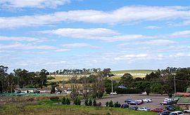
Castle Hill is a town in Sydney, New South Wales, Australia, located 34 kilometres north-west of the Sydney central business district and 9.5 kilometres north of Parramatta. It is within the Hills District region, split between the local government areas of The Hills Shire and Hornsby Shire.

<span class="mw-page-title-main">Beverly Hills, New South Wales</span> Suburb of Sydney, New South Wales, Australia

Beverly Hills is a southern suburb of Sydney, in the state of New South Wales, Australia. Beverly Hills is located 15 kilometres southwest of the Sydney central business district and is part of the St George area and is split between the local government areas of the Georges River Council and the City of Canterbury-Bankstown. The postcode is 2209, which it shares with neighbouring Narwee.

<span class="mw-page-title-main">Blacktown</span> City in New South Wales, Australia

Blacktown is a city in the City of Blacktown local government area, in the state of New South Wales, Australia. Blacktown is located 34 km (21 mi) west of the Sydney central business district. It is one of the most multicultural places within Greater Sydney.

<span class="mw-page-title-main">Doonside, New South Wales</span> Suburb of Sydney, New South Wales, Australia

Doonside is a suburb in Sydney, in the state of New South Wales, Australia. Doonside is located 40 kilometres west of the Sydney central business district, in the local government area of the City of Blacktown and is part of the Greater Western Sydney region. Featherdale Wildlife Park and the Nurragingy Nature Reserve are popular local tourist attractions.

<span class="mw-page-title-main">Greater Western Sydney</span> Region of the metropolitan area of Sydney, Australia

Greater Western Sydney (GWS) is a large region of the metropolitan area of Greater Sydney, New South Wales (NSW), Australia that generally embraces the north-west, south-west, central-west, far western and the Blue Mountains sub-regions within Sydney's metropolitan area and encompasses 11 local government areas: Blacktown, Blue Mountains, Camden, Campbelltown, Cumberland, Fairfield, Hawkesbury, Liverpool, Parramatta, Penrith and Wollondilly. It includes Western Sydney, which has a number of different definitions, although the one consistently used is the region composed of ten local government authorities, most of which are members of the Western Sydney Regional Organisation of Councils (WSROC). The NSW Government's Office of Western Sydney calls the region "Greater Western Sydney".

<span class="mw-page-title-main">Division of Chifley</span> Australian federal electoral division

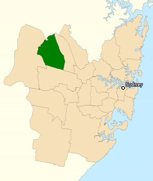
The Division of Chifley is an Australian electoral division in the state of New South Wales.

<span class="mw-page-title-main">Seven Hills, New South Wales</span> Suburb of Sydney, New South Wales, Australia

Seven Hills is a suburb in the Greater Western Sydney region of Sydney, in the state of New South Wales, Australia, located 33 kilometres North West of the Sydney central business district. Seven Hills is within the local government areas of the City of Parramatta and Blacktown City councils.

<span class="mw-page-title-main">Rooty Hill railway station</span> Railway station in Sydney, New South Wales, Australia

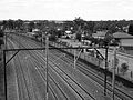
Rooty Hill railway station is located on the Main Western line, serving the Sydney suburb of Rooty Hill. It is served by Sydney Trains T1 Western line services.

<span class="mw-page-title-main">Mount Druitt railway station</span> Railway station in Sydney, New South Wales, Australia

Mount Druitt railway station is located on the Main Western line, serving the Sydney suburb of Mount Druitt. It is served by Sydney Trains T1 Western line services.

<span class="mw-page-title-main">Mount Druitt</span> Suburb of Sydney, New South Wales, Australia

Mount Druitt is a suburb of Sydney, in the state of New South Wales, Australia. It is located 43 kilometres (27 mi) west of the Sydney central business district, in the local government area of the City of Blacktown, and is part of the Greater Western Sydney region.

<span class="mw-page-title-main">Kellyville Ridge, New South Wales</span> Suburb of Sydney, New South Wales, Australia

Kellyville Ridge is a suburb of Sydney, in the state of New South Wales, Australia. Kellyville Ridge is located 41 kilometres north-west of the Sydney central business district in the local government area of City of Blacktown. It is part of Greater Western Sydney.

<span class="mw-page-title-main">Rooty Hill historic site</span> Historic site in New South Wales, Australia

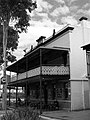
Rooty Hill is a heritage-listed historic site and now parkland at Eastern Road, Rooty Hill, City of Blacktown, New South Wales, Australia. It was built from 1802 to 1828. It is also known as The Rooty Hill and Morreau Reserve. The property is owned by the Presbyterian Church (NSW) Property Trust. It was added to the New South Wales State Heritage Register on 13 June 2007.

<span class="mw-page-title-main">Minchinbury, New South Wales</span> Suburb of Sydney, New South Wales, Australia

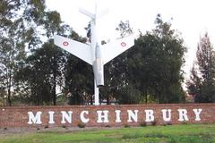
Minchinbury is a small suburb in western Sydney, in the state of New South Wales, Australia. Minchinbury is located 38 kilometres (24 mi) west of the Sydney central business district, in Blacktown local government area and is part of the Greater Western Sydney region.

<span class="mw-page-title-main">Plumpton, New South Wales</span> Suburb of Sydney, New South Wales, Australia

Plumpton is located 45 kilometres west of the Sydney central business district, in the local government area of the City of Blacktown and is part of the Greater Western Sydney region.

<span class="mw-page-title-main">Riverstone, New South Wales</span> Suburb of Sydney, New South Wales, Australia

Riverstone is a suburb of Sydney in the state of New South Wales, Australia. Riverstone is located 48 kilometres (30 mi) north-west of the Sydney central business district, in the Blacktown local government area and part of the Greater Western Sydney region. Originally settled in 1803 as part of a government stock farm, Riverstone is one of the oldest towns in Australia.

<span class="mw-page-title-main">Blacktown City Council</span> Local government area in New South Wales, Australia

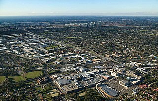
Blacktown City Council is a local government area in Western Sydney, situated on the Cumberland Plain, approximately 35 kilometres (22 mi) west of the Sydney central business district, in the state of New South Wales, Australia. Established in 1906 as the Blacktown Shire and becoming the Municipality of Blacktown in 1961 before gaining city status in 1979, the City occupies an area of 246.9 square kilometres (95.3 sq mi) and has a population of 410,419, making it the most populous local government area in Sydney.

<span class="mw-page-title-main">Electoral district of Mount Druitt</span>

Mount Druitt is an electoral district of the Legislative Assembly in the Australian state of New South Wales. It is represented by Edmond Atalla of the Labor Party.

<span class="mw-page-title-main">St Agnes Catholic High School</span> School in Australia

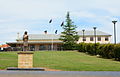
St Agnes Catholic High School is an independent Roman Catholic co-educational secondary day school, located in Rooty Hill, in the western suburbs of Sydney, New South Wales, Australia. The school caters for approximately 800 students from Year 7 to Year 12 and draws students from St Aidan's Primary, Rooty Hill, Sacred Heart Primary, Mount Druitt, and St John Vianney's Primary, Doonside, as well as a number of other schools in the surrounding suburbs. It also serves the parishes of St Aidan's Rooty Hill, Sacred Heart South Mount Druitt, Holy Family Emerton and St John Vianney's Doonside. The school is a Franciscan Missionaries of Mary school maintaining the Franciscan spirit of simplicity, acceptance of all and a deep personal love of Jesus.

<span class="mw-page-title-main">Edmond Atalla</span> Australian politician

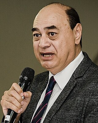
Edmond Atalla is an Australian politician and professional engineer. A member of the Labor Party, Atalla has represented Mount Druitt in the New South Wales Legislative Assembly since 2015. The child of Coptic Egyptian parents, Atalla is known for his advocacy for members of Australia's Coptic community.

Caddens is a suburb of Sydney, in the state of New South Wales in Australia. It is a new masterplanned residential neighborhood located 48 kilometres west of the Sydney central business district, in the local government area of the City of Penrith featuring views of the scenic Blue Mountains. The suburb's postcode is 2747.

References

  1. Australian Bureau of Statistics (27 June 2017). "Rooty Hill (State Suburb)". 2016 Census QuickStats. Retrieved 11 March 2018. OOjs UI icon edit-ltr-progressive.svg
  2. "Timeline for Rooty Hill District". Blacktown City Council. Archived from the original on 27 December 2013. Retrieved 19 September 2013.
  3. Rooty Hill Road, Kingston, Norfolk Island, Google Maps, accessed 7 March 2013
  4. "The Rooty Hill". New South Wales Heritage Register. Retrieved 28 November 2015.
  5. "Watts Cottage". nsw.gov.au. Retrieved 7 November 2015.
  6. "Imperial Hotel". nsw.gov.au. Retrieved 7 November 2015.
  7. "Pioneer Memorial Church". nsw.gov.au. Retrieved 7 November 2015.
  8. "08 Nov 1902 - Rooty Hill School of Arts. LAYING THE FOUNDATION..." nla.gov.au. 8 November 1902. Retrieved 7 November 2015.
  9. "School of Arts". nsw.gov.au. Retrieved 7 November 2015.
  10. "13 Apr 1916 - MR. J. ANGUS KILLED. PIONEER RAILWAY CONTRACTOR..." nla.gov.au. 13 April 1916. Retrieved 7 November 2015.
  11. "Fairholme". nsw.gov.au. Retrieved 7 November 2015.
  12. "Government Depot Site (former)". New South Wales State Heritage Register . Department of Planning & Environment. H00345. Retrieved 18 May 2018. CC BY icon.svg Text is licensed by State of New South Wales (Department of Planning and Environment) under CC-BY 4.0 licence .
  13. "Rooty Hill, The". New South Wales State Heritage Register . Department of Planning & Environment. H01756. Retrieved 18 May 2018. CC BY icon.svg Text is licensed by State of New South Wales (Department of Planning and Environment) under CC-BY 4.0 licence .
  14. "Imperial Hotel". New South Wales State Heritage Register . Department of Planning & Environment. H00114. Retrieved 18 May 2018. CC BY icon.svg Text is licensed by State of New South Wales (Department of Planning and Environment) under CC-BY 4.0 licence .
  15. "2021 Rooty Hill, Census All persons QuickStats | Australian Bureau of Statistics". abs.gov.au. Retrieved 26 March 2023.
  16. "2021 Rooty Hill, Census All persons QuickStats | Australian Bureau of Statistics". abs.gov.au. Retrieved 26 March 2023.
  17. "Home | West HQ | Leading Landmark Destination". West HQ. Retrieved 25 March 2023.
  18. "Rooty Hill Public School". www.rootyhill-p.schools.nsw.edu.au. Retrieved 6 November 2015.
  19. Happy returns, Mt Druit - St Marys Standard. 23 May 2007.
  20. "Welcome to St Aidan's Primary, Rooty Hill". www.staidansrootyhill.catholic.edu.au. Retrieved 6 November 2015.
  21. "St Agnes Catholic High School, Rooty Hill". www.stagnesrootyhill.catholic.edu.au. Retrieved 6 November 2015.
  22. "Rooty Hill High School". Welcome to Rooty Hill High School. Rooty Hill High School. 2015. Retrieved 6 November 2015.
  23. "St Alban's Multicultural Bible Ministry". St Alban's Multicultural Bible Ministry. Retrieved 6 November 2015.
  24. "Rooty Hill Uniting Church" . Retrieved 6 November 2015.
  25. "Rooty Hill - St Aidan's Parish". Diocese of Parramatta. Retrieved 6 November 2015.
  26. "Pioneer Memorial Church". www.estes-eastes.org. Retrieved 6 November 2015.
  27. "Minchinbury Anglican Church". www.minchinburyanglican.org.au. Archived from the original on 10 January 2016. Retrieved 6 November 2015.

33°46′18″S150°50′38″E / 33.77167°S 150.84389°E / -33.77167; 150.84389