Government Depot Site, Rooty Hill

Last updated

Government Depot Site
345 - Government Depot Site (former) - View of the site from Dunsmore Street, looking southwards towards Rooty Hill, with the vegetated area marking the house site (5045415b4).jpg
View of the site from Dunsmore Street, looking southwards towards Rooty Hill, with the vegetated area marking the house site
LocationDunsmore Street, Rooty Hill, City of Blacktown, New South Wales, Australia
Coordinates 33°46′27″S150°51′03″E / 33.7743°S 150.8509°E / -33.7743; 150.8509 Coordinates: 33°46′27″S150°51′03″E / 33.7743°S 150.8509°E / -33.7743; 150.8509
Built18151819
OwnerDepartment of Planning and Infrastructure
Official nameGovernment Depot Site (former); Government Depot Ruins; Thornleigh; Stratton; Rooty Hill Government Farm
Typestate heritage (complex / group)
Designated2 April 1999
Reference no.345
TypeHomestead Complex
CategoryFarming and Grazing
BuildersNot known
Australia New South Wales relief location map.png
Red pog.svg
Location of Government Depot Site in New South Wales

Government Depot Site is a heritage-listed archaeological site at the location of the former Government Stock Farm at Dunsmore Street, Rooty Hill, City of Blacktown, New South Wales, Australia. It was built from 1815 to 1819 It is also known as Government Depot Site (former), Government Depot Ruins, Thornleigh, Stratton and Rooty Hill Government Farm. The property is owned by Department of Planning and Infrastructure (State Government). It was added to the New South Wales State Heritage Register on 2 April 1999. [1]

Contents

History

There is much speculation about the source of the name Rooty Hill. Mr William Freame wandered much in these parts collecting information from old residents. In 1931 in an article in a country newspaper on place names he wrote regarding the name: "Old hands assure me that the hill received its name from the roots and other debris left around its bare fields when the Eastern Creek was in flood, and this appears to be a very reasonable deduction." Mrs Hawkins description quoted later in the derivation does not appear reasonable. Captain J H Watson's version, he as a young man having been in India, and he derives the name from "ruti", the Hindustani word for bread. Governor Macquarie as a young man had been in India, and if the settlement at the hill had been devoted to agriculture there would have been a connection, but it was a stockyard. A third and anonymous writer puts forward a Captain Thomas Rooty as a resident in the locality. No information can be found on him. [1]

The district was used as a Government stockyard, and in a lengthy list which Governor Macquarie prepared of the buildings and works erected during his regime between January 1810 and November 1821, we find the following:

"At Rooty Hill:
1. a brick built house of two stories high for the residence and accommodation of the superintendent and principal overseer of the Government stock at the station, reserving one room for the use of the Governor, when occasionally there, with kitchen, stables and other necessary out-offices and kitchen garden enclosed;
2. four paddocks of 50 acres, each enclosed for the grazing of young cattle and raising of wheat and maize for the use of the stockmen;
3. temporary log huts or barracks for the accommodation of 20 stockkeepers, with small kitchen garden attached thereto.
NB: The station at Rooty Hill is the next principal one to Camden for the grazing of the Government horned cattle and horses, and consists of about 6000 acres of land of a very superior description, and, as this grazing ground is centrically situated, being on the Great Western Road and only 10 miles distant from Parramatta, it ought not to be on any account alienated from the Crown. [1] [2]

Macquarie seems to have forgotten that he had already carved a large slice off the reservation by giving Major Druitt in October 1821 a grant of 1000 acres 'out of the Rooty Hill Government allotment on Ross's Creek'. Mount Druitt is a permanent reminder of this grant. In 1824 Captain P. P. King, son of Governor King, was given a grant of 1500 acres, also part of the Rooty Hill establishment. [1] [2]

On January 11, 1822 T. H. Hawkins arrived in Sydney with wife and 8 children and mother in law. A few months later he received an appointment as commissariat storekeeper at Bathurst, and on April 5 set out from Sydney, at the head of a cavalcade of bullock wagons, carts, drays and belongings over the Blue Mountains to their new home. Late that night the party reached Rooty Hill, a distance of 25 miles from Sydney, the Government House was ready to receive them. ...Hawkins described the place "I could have been contented to remain there for ever - the house was good, and the land around like a fine wooded park in England". [1] [2]

The "brick built house of two stories" still stands (1935), with galvanised iron roof (seen in a photo) where once it was shingle-rooved. The oak tree (also shown in a photo) would have been small in Macquarie's time, but is now a veteran, ... a sturdy sample of the genus' (sic). [1] [2]

Very little is known about the history of the site other than that it was a Stock Farm, whose original boundary was the present City of Blacktown perimeter. The original building on the site was the Superintendent's residence and was also used by Governor Macquarie and other passing travellers. The site was later known as "Thornleigh" and then "Stratton" although the origin of these names is not known. [1]

Two rooms were added for Governor Macquarie's convenience. It was in a ruinous state in the 1960s, and was demolished. [3] [1]

1935 photographs showed the two story "old homestead on old Government Stock Farm, Rooty Hill", with two chimneys at each end gable, a half-hipped/hipped gable roof form, what appears to be a gum tree to one side, close to the house, and a low picket fence in front. Another photograph showed a fairly large oak tree (Quercus sp., probably common English oak, Q.robur) at the same location, with a picket fenced paddock around it. [4] [1]

Description

Underground tank, possibly the well 345 - Government Depot Site (former) - Part of the concrete-covered brick wall of the underground tank, filled with building debris that may or may not be from the site. (5045415b1).jpg
Underground tank, possibly the well

The site once comprised the former c.6000 acre Government Stock Farm and associated Superintendent's residence built in 1815. [1]

Broken bricks within the vegetation growing over the house site 345 - Government Depot Site (former) - View showing broken bricks and other archaeological deposits beneath the vegetation growing over the house site (5045415b3).jpg
Broken bricks within the vegetation growing over the house site

Between January 1810 and November 1821, there was (in terms of buildings on site): [1]

"At Rooty Hill:
1. a brick built house of two stories high for the residence and accommodation of the superintendent and principal overseer of the Government stock at the station, reserving one room for the use of the Governor, when occasionally there, with kitchen, stables and other necessary out-offices and kitchen garden enclosed;
2. four paddocks of 50 acres, each enclosed for the grazing of young cattle and raising of wheat and maize for the use of the stockmen;
3. temporary log huts or barracks for the accommodation of 20 stockkeepers, with small kitchen garden attached thereto. [1]

From a walk around the overgrown area where the original building is thought to have been, there is little visible evidence remaining of any structures above ground. The area is almost completely overgrown with thorn bushes. The only evidence found included several timber posts, from a post and rail fence and a large cement rendered brick pit (possibly a well). It has been filled with various items and debris. Remnants of the garden which would have served the main building are discernable, as is the overall form of the garden. [1]

A 1992 DUAP listing described the remains of the depot to include: mounds of bricks, stone flagging, timber slabs, and a five-metre-diameter (16 ft) well, however, with the exception of the well, none of these structures are visible and appear unlikely to have survived. [1]

Condition

The residence was a ruin as at 23 November 2000, although its exact condition could not be ascertained owing to the overgrown condition of the site. The site has high potential archaeological value associated with its former use as a Government Stock Farm. [1]

It is considered that there is very little, if any built fabric remaining and the overseer's house site cannot therefore be considered to be intact. However it does retain the overall form and elements of the house's garden, and open space, remnant of the former Government Stock Farm. [5] [1]

Very little is known about the site and a detailed physical survey does not appear to have been carried out to date. Owing to the site's former use and its association with Governor Macquarie, further investigation is warranted. Due to the uncertainty whether there is anything left of the building at all, there is some urgency attached to this. What remains of the site should be carefully documented. If there is very little remaining, there may be potential for the site's removal from the register. [1]

Heritage listing

Heritage boundaries 345 - Government Depot Site (former) - PCO Plan Number 345 (5045415p1).jpg
Heritage boundaries

The Government Depot site has potential State significance for its association with Governor Macquarie and is certainly of regional significance as the former residence of the Superintendent of the stock farm. The site also has local significance through its association with early travellers and settlers in the district. [1]

The station at Rooty Hill was the next principal one to that at Camden for the grazing of the Government horned cattle and horses in the early 1800s. [4] [1]

Government Depot Site was listed on the New South Wales State Heritage Register on 2 April 1999 having satisfied the following criteria. [1]

The place is important in demonstrating the course, or pattern, of cultural or natural history in New South Wales.

The (former) Government Depot site is of historical significance for its association with Governor Macquarie and other travellers and early settlers in the Blacktown/Rooty Hill district. It is also of significance for its former role as a Government Stock Farm. As part of the Government Stock Farm it was the second most important Government Station in the colony, after Camden. [6] [1]

The place is important in demonstrating aesthetic characteristics and/or a high degree of creative or technical achievement in New South Wales.

The (former) Government Depot retains the fabric of a portion of the Government Stock Farm's original 6000 acres of land, and as open space which could be read as still "rural", it has some aesthetic value, and some rarity in modern Western Sydney. [6] [1]

The superintendent's house site is considered to have little, if any, remaining built fabric. The site does retain the overall form and remnants of the overseer's garden. This latter site therefore has relatively little aesthetic significance, at present. [7] [1]

The place has strong or special association with a particular community or cultural group in New South Wales for social, cultural or spiritual reasons.

The (former) Government Depot is of social significance for its association with early settlers and travellers through the Blacktown/Rooty Hill district. It has further significance for the role it played in the raising of stock for the young colony and for its association with early industry in the district. It would have provided employment for many early settlers. [8] [1]

The place has potential to yield information that will contribute to an understanding of the cultural or natural history of New South Wales.

The (former) Government Depot may be of technical significance should the existence of any early structures be confirmed, and for its association with early farming and stock raising techniques - which may be demonstrated through any remains on the site which are yet to be discovered. These may provide insights into field sizes, shapes, fencing materials and types, animal and crop residues. [7] [1]

The place possesses uncommon, rare or endangered aspects of the cultural or natural history of New South Wales.

The (former) Government Depot retains the fabric of a portion of the Government Stock Farm's original 6000 acres of land, and as open space which could be read as still "rural", it has some aesthetic value, and some rarity in modern Western Sydney. As part of the Government Stock Farm it was the second most important Government Station in the colony, after Camden. [6] [1]

The place is important in demonstrating the principal characteristics of a class of cultural or natural places/environments in New South Wales.

The Government Stock Farm was one of the two most important such stations in the colony in the early 1820s, and still retains potential to demonstrate through its archaeological resources, a representative example of a colonial era farm, with typical farm elements of that era. [6] [1]

See also

Related Research Articles

<span class="mw-page-title-main">Rooty Hill, New South Wales</span> Suburb of Sydney, New South Wales, Australia

Rooty Hill is a suburb of Sydney, in the state of New South Wales, Australia. Rooty Hill is located 42 kilometres west of the Sydney central business district, in the local government area of the City of Blacktown and is part of the Greater Western Sydney region.

<span class="mw-page-title-main">The Domain, Sydney</span> Park in Sydney, Australia

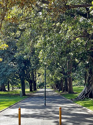
The Domain is a heritage-listed 34-hectare (84-acre) area of open space located on the eastern fringe of the Sydney central business district, in the City of Sydney local government area of New South Wales, Australia. Separating the central business district from Woolloomooloo, The Domain adjoins the Royal Botanic Gardens and is managed by the Royal Botanic Gardens Trust, a division of the NSW Office of Environment and Heritage, an agency of the Government of New South Wales. The Domain is used as a venue for outdoor concerts, open-air events, large political gatherings and rallies, as well as being used daily by the people of Sydney for exercise and relaxation. Along with the Royal Botanic Gardens, The Domain was added to the New South Wales State Heritage Register on 2 April 1999.

<span class="mw-page-title-main">Royal Botanic Garden, Sydney</span> Botanic gardens in Sydney, New South Wales, Australia

The Royal Botanic Garden, Sydney is a heritage-listed major 30-hectare (74-acre) botanical garden, event venue and public recreation area located at Farm Cove on the eastern fringe of the Sydney central business district, in the City of Sydney local government area of New South Wales, Australia.

<span class="mw-page-title-main">Rooty Hill historic site</span> Historic site in New South Wales, Australia

Rooty Hill is a heritage-listed historic site and now parkland at Eastern Road, Rooty Hill, City of Blacktown, New South Wales, Australia. It was built from 1802 to 1828. It is also known as The Rooty Hill and Morreau Reserve. The property is owned by the Presbyterian Church (NSW) Property Trust. It was added to the New South Wales State Heritage Register on 13 June 2007.

<span class="mw-page-title-main">Minchinbury, New South Wales</span> Suburb of Sydney, New South Wales, Australia

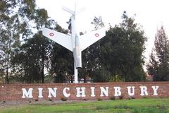
Minchinbury is a small suburb in western Sydney, in the state of New South Wales, Australia. Minchinbury is located 38 kilometres (24 mi) west of the Sydney central business district, in Blacktown local government area and is part of the Greater Western Sydney region.

<span class="mw-page-title-main">Tahlee</span> Historic site in New South Wales, Australia

Tahlee is a heritage-listed former pastoral property of 68.8 hectares in the suburb of Tahlee situated on the north side of Port Stephens near Karuah in New South Wales, Australia. It is the original site of the Australian Agricultural Company and more recently the location of the former Tahlee Bible College. It was added to the New South Wales State Heritage Register on 2 April 1999.

<span class="mw-page-title-main">Old Government House, Parramatta</span> Mansion in New South Wales, Australia

The Old Government House is a heritage-listed former "country" residence used by ten early governors of New South Wales between 1800 and 1847, located in Parramatta Park in Parramatta, New South Wales, in the greater metropolitan area of Western Sydney, New South Wales, Australia. It is considered a property of national and international significance as an archaeological resource. It also serves to demonstrate how the British Empire expanded and Australian society has evolved since 1788.

<span class="mw-page-title-main">Nurragingy Reserve</span>

The Nurragingy Nature Reserve is an Australian open urban park and forest, nature reserve and garden, it is a protected area owned by Western Sydney Parklands Trust and operated by Blacktown City Council that opened in 1981. The Nature Reserve is a site of state heritage significance because of its combination of historical, social and cultural values. The site was the first land grant ever given to Aboriginal people in Australia.

<span class="mw-page-title-main">Royal Hotel, Bathurst</span> Historic site in New South Wales, Australia

The Royal Hotel is a heritage-listed former hotel and now commercial and apartment building located at 108 William Street, Bathurst, Bathurst Region, New South Wales, Australia. The property is privately owned. It was added to the New South Wales State Heritage Register on 2 April 1999.

<span class="mw-page-title-main">Blacktown Native Institution Site</span> Historic site in New South Wales, Australia

The Blacktown Native Institution Site is the heritage-listed site of a former residential school for Aboriginal and Māori children at Richmond Road, Oakhurst, City of Blacktown, New South Wales, Australia. It was built from 1822. The site has also been known as Parramatta Native Institute, Black Town Institute, The Blacktown Site, Lloydhurst, BNI, Epping Estate, Epping Forest Estate and Native Institution Centre. The property is owned by Blacktown City Council, Department of Planning and Infrastructure and Landcom. It was added to the New South Wales State Heritage Register on 18 November 2011.

<span class="mw-page-title-main">Prospect Post Office</span> Historic site in New South Wales, Australia

Prospect Post Office is a heritage-listed former post office and shop at 23 Tarlington Place, Prospect, City of Blacktown, New South Wales, Australia. It was designed by James Watts and built by Watts from 1880 to 1890. The property is owned by the City of Blacktown. It was added to the New South Wales State Heritage Register on 2 April 1999.

<span class="mw-page-title-main">Grantham Poultry Research Station</span> Historic site in New South Wales, Australia

The Grantham Poultry Research Station is a heritage-listed former poultry farm and research station and now heritage reserve at 71 Seven Hills Road, Seven Hills, City of Blacktown, New South Wales, Australia. It includes two historic residences, Melrose and Drumtochty. The site is today known as the Grantham Heritage Park, and has previously been known as Seven Hills Agricultural Station and the Grantham State Poultry Farm. It was built from 1897 to 1939. It was added to the New South Wales State Heritage Register on 7 April 2000.

<span class="mw-page-title-main">Bungarribee Homestead Site</span> Historic site in New South Wales, Australia

The Bungarribee Homestead Site is a heritage-listed archaeological site at the location of the former Bungarribee Homestead. The site is located at Doonside Road, Doonside, City of Blacktown, Sydney New South Wales, Australia. It was added to the New South Wales State Heritage Register on 8 December 2000.

<span class="mw-page-title-main">Third Government Farm</span> Historic site in New South Wales, Australia

The Third Government Farm is a heritage-listed garden at Gilbert Road, near Old Northern Road, Castle Hill, The Hills Shire, New South Wales, Australia. It was built during 1801. It is also known as Castle Hill Heritage Park; Third Government Farm (former); Castle Hill Settlement Site; Old Government Farm Site; Castle Hill Convict Farm; Castle Hill Historic Site. The property is owned by The Hills Shire Council. It was added to the New South Wales State Heritage Register on 22 December 2000.

The Toongabbie Government Farm Archaeological Site is the heritage-listed site of a former convict government farm at Goliath Avenue, Winston Hills, City of Parramatta, New South Wales, Australia. The farm was built by convict labour from 1791 to 1813. Its site includes areas today known as Palestine Park, Oakes Reserve and Settlers Walk and is also known as the Toongabbie Government Farm Convict Site. It was added to the New South Wales State Heritage Register on 11 December 2012.

<span class="mw-page-title-main">Kelvin, Bringelly</span> Historic site in Sydney New South Wales, Australia

Kelvin is a heritage-listed residence at 30 The Retreat, Bringelly, City of Liverpool, Sydney, New South Wales, Australia. It was built from 1820 to 1826 by Thomas Laycock. It is also known as Retreat Farm, The Retreat, Thomas Laycock's Cottage Vale and Cottage-ville. It was added to the New South Wales State Heritage Register on 2 April 1999.

<i>Macquarie Grove</i> Historic site in New South Wales, Australia

Macquarie Grove is a heritage-listed former airport administration offices and private residence and now private residence located at Aerodrome Road, Cobbitty, in the south-western Sydney suburb of Camden in the Camden Council local government area of New South Wales, Australia. It was built from 1812 to 1850. The property is privately owned. It was added to the New South Wales State Heritage Register on 2 April 1999.

<i>Harrington Park</i> (homestead) Historic site in New South Wales, Australia

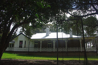
Harrington Park is a heritage-listed former race track, rural estate management and alluvial grazing paddocks located at 1 Hickson Circuit in the south-western Sydney suburb of Harrington Park in the Camden Council local government area of New South Wales, Australia. The original designer is unconfirmed, with 1950-60s additions completed by Marcel Weyland. The homestead was built from 1817 to 1827. The property is privately owned and was added to the New South Wales State Heritage Register on 22 December 2006.

<span class="mw-page-title-main">Government Cottage Archaeological Site</span> Historic site in New South Wales, Australia

Government Cottage Archaeological Site is the heritage-listed site of a cottage which served alternately as the base for the Colony of New South Wales' commandant of the Hawkesbury district, house of the district's magistrate and an "informal official residence" for the Governor of New South Wales when in the district. It is located at 41 George Street, Windsor, City of Hawkesbury, New South Wales, Australia. The original house was built from 1796 to 1815 and demolished c. 1920-21. It was also known as Commandant's House and Government House. It was added to the New South Wales State Heritage Register on 4 February 2011.

Windmill Hill is a heritage-listed former farm and now water catchment area located at Wilton Road in the outer south-western Sydney settlement of Appin in the Wollondilly Shire local government area of New South Wales, Australia. It was built from 1820 to 1950. It is also known as Windmill Hill Group, including Ruins, North Farm, Middle Farm aka Larkin Farm and Windmill Hill, South Farm and Steven's Homestead. The property is owned by Water NSW. It was added to the New South Wales State Heritage Register on 27 June 2014.

References

  1. 1 2 3 4 5 6 7 8 9 10 11 12 13 14 15 16 17 18 19 20 21 22 23 24 25 26 27 "Government Depot Site (former)". New South Wales State Heritage Register . Department of Planning and Environment. H00345. Retrieved 1 June 2018. CC-BY icon.svg Text is licensed by State of New South Wales (Department of Planning and Environment) under CC-BY 4.0 licence .
  2. 1 2 3 4 (the above paragraphs are all from: Bertie, 1935, p36, 37, with slight modifications/paraphrasing by Read, S., 2006).
  3. Broadbent & Hughes, 1988
  4. 1 2 Bertie, 1935
  5. DUAP, 1999 and Read, S., 2006
  6. 1 2 3 4 Bertie, 1935, and Read, S., pers. comm., 2006
  7. 1 2 DUAP, 1999 and Read, S., pers. comm., 2006
  8. DUAP, 1999

Bibliography

Attribution

CC BY icon-80x15.png This Wikipedia article was originally based on Government Depot Site (former) , entry number 00345 in the New South Wales State Heritage Register published by the State of New South Wales (Department of Planning and Environment) 2018 under CC-BY 4.0 licence , accessed on 1 June 2018.