Kellyville Ridge, New South Wales

Last updated

Kellyville Ridge
Sydney,  New South Wales
Kellyville Ridge Upside Down Umbrellas Night View.jpg
Kellyville Ridge, New South Wales
Map
Population10,890 (2021 census) [1]
Established2002
Postcode(s) 2155
Elevation74 m (243 ft)
Location41 km (25 mi) north-west of Sydney CBD
LGA(s) City of Blacktown
State electorate(s) Riverstone
Federal division(s) Greenway
Suburbs around Kellyville Ridge:
The Ponds Rouse Hill Rouse Hill
The Ponds Kellyville Ridge Beaumont Hills
Stanhope Gardens Stanhope Gardens Kellyville

Kellyville Ridge is a suburb of Sydney, in the state of New South Wales, Australia. Kellyville Ridge is located 41 kilometres north-west of the Sydney central business district in the local government area of City of Blacktown. It is part of Greater Western Sydney.

Contents

History

The suburb takes its name from the ridge, the main geographical feature of vertical significance in the northern part of the area. Kellyville Ridge is thought to be the area where the Castle Hill Rebellion (also known as the Second Battle of Vinegar Hill) took place, many roads and reserves are named after it in Kellyville and a memorial was placed in Castlebrook Lawn Cemetery in 1988. Kellyville Ridge was originally part of Kellyville and became a separate suburb when the area west of Windsor Road was renamed in 2002. [2]

Heritage listings

Kellyville Ridge has a number of heritage-listed sites, including:

Population

In the 2021 Census, there were 10,890 people in Kellyville Ridge. 54.0% of people were born in Australia. The next most common countries of birth were India 13.0%, Philippines 3.6%, China 2.2%, Fiji 1.8% and England 1.7%. 52.8% of people spoke only English at home. Other languages spoken at home included Hindi 5.1%, Punjabi 4.9%, Mandarin 2.7%, Gujarati 2.3% and Arabic 2.1%. The most common responses for religion were Catholic 25.7%, No Religion 18.9%, Hinduism 14.3% and Islam 8.4%. [1]

Growth

Kellyville Ridge is one of the fastest growing suburbs in Sydney. Population estimates by the Australian Bureau of Statistics indicated that Kellyville Ridge and surrounding neighbourhoods had the largest growth in 2013–14 in Sydney. The area experienced one of metropolitan Sydney's fastest growth rates, with a 9 per cent increase in population in 12 months. [4]

Commercial area

The Ponds Shopping Centre, opened on 30 May 2015, is the main shopping facility that services Kellyville Ridge. It is located on the western perimeter of the suburb at the intersection of The Ponds Boulevard and Riverbank Drive. It houses Woolworths plus other 25 specialty stores, cafes and restaurants. It also features a Medical and Dental Centre and a Priceline Pharmacy. [5]

Stanhope Village is a shopping centre adjacent to the suburb, with Aldi, Coles, Kmart and other specialised retail, service, fashion and food outlets. [6]

Stanhope Village Shopping Centre Stanhope Village.jpg
Stanhope Village Shopping Centre

Alternative shopping is provided by the Rouse Hill Town Centre, located 1 kilometre away at Rouse Hill, where approximately 250 retail stores are available featuring Coles, Woolworths, Target, Big W and Reading Cinemas. Castle Towers, located 9 kilometres away, and Westpoint Blacktown, located 10 kilometres away, provide for other places of shopping.

Education

School located in Kellyville Ridge includes:

Kellyville Ridge has the following public school catchment:

Transport

Road to Sydney CBD

Transport to the city is provided by the M2 and M7 motorway. Driving time to Sydney CBD is approximately 34 minutes by car. [8]

Train to Sydney CBD via Parramatta

Kellyville Ridge is located within 8 minutes drive (5.2 km) to Schofields railway station and 10 minutes (6 km) to Quakers Hill railway station. Trip by train from these stations to Sydney CBD takes around 47 minutes. Both stations have free all-day commuters parking. The train services also stop at the busy business area of Parramatta, Westmead and Strathfield.

Buses to Sydney CBD

CDC NSW services take around 1 hour to Sydney CBD from Kellyville Ridge. The suburb is serviced by the 616X which travels through Kellyville Ridge.

Sydney Metro to Chatswood

The North West Rail Link which opened 26 May 2019 – now known as Sydney Metro Northwest – provides high frequency services to Kellyville Ridge, linking it to Sydney CBD in around 50 minutes, which will drop to 40 minutes on completion of the second stage of the project. The metro service passes through Norwest Business Park, Castle Hill, Epping, Macquarie Park and University, North Ryde, Chatswood, and North Sydney. [9]

Kellyville Ridge is positioned in a strategic location surrounded by three railway stations sitting on its perimeters; Tallawong, Rouse Hill and Kellyville. Both Tallawong and Kellyville provide all-day commuter parking. [10] CDC NSW route 663 and Busways route 731 connect Kellyville Ridge with the Rouse Hill metro station, whilst CDC NSW routes 603, 632 (from Merriville Road and Perfection Ave) and 651 (from Merriville T-way) connect to Kellyville station.

Buses to other business areas

CDC NSW provides services to Parramatta (603, 663, 665), Rouse Hill (603, 632, 651, 663, 665), Epping (651) and Pennant Hills (632).

Busways provides services to Blacktown (731, 735) and Rouse Hill (731, 735).

Entertainment

Ettamogah Pub, Kellyville Ridge (1)Ettamogah Pub-2.jpg
Ettamogah Pub, Kellyville Ridge

The Ettamogah Pub renovated in 2014 is located on the corner of Merriville & Windsor Roads. The hotel received from the Australian Hotel Association the award for Best Family Friendly Hotel in New South Wales. [11]

Housing

Kellyville Ridge has gone under many new developments since 2002, with new estates developing quickly. There are also several medium-rise apartments on the southern side of the suburb, backing Windsor Road.

Related Research Articles

<span class="mw-page-title-main">Castle Hill, New South Wales</span> Suburb of Greater Western Sydney, New South Wales, Australia

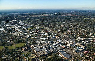
Castle Hill is a suburb of Sydney, New South Wales, Australia, located 34 kilometres north-west of the Sydney central business district and 9.5 kilometres north of Parramatta. It is within the Hills District region, split between the local government areas of The Hills Shire and Hornsby Shire.

<span class="mw-page-title-main">Blacktown</span> Suburb of Sydney, New South Wales, Australia

Blacktown is a suburb in the City of Blacktown, in the state of New South Wales, Australia. Blacktown is located 34 km (21 mi) west of the Sydney central business district. It is one of the most multicultural places within Greater Sydney.

<span class="mw-page-title-main">Bella Vista, New South Wales</span> Suburb of Greater Western Sydney, New South Wales, Australia

Bella Vista is located 33 kilometres north-west of the Sydney central business district and is part of The Hills Shire. It is a suburb in the Hills District of Greater Western Sydney and is in the state of New South Wales, Australia. Bella Vista's Norwest Business Park is home to several Fortune 500 companies, a number of shopping centres, high-rise buildings, and industrial and recreational spaces.

<span class="mw-page-title-main">Division of Greenway</span> Australian federal electoral division

The Division of Greenway is an Australian electoral division in the state of New South Wales.

<span class="mw-page-title-main">Blacktown railway station</span> Railway station in Sydney, New South Wales, Australia

Blacktown railway station is located on the Main Western line, serving the Sydney suburb of Blacktown. It is served by Sydney Trains T1 Western Line and T5 Cumberland Line services and NSW TrainLink Intercity Blue Mountains Line and regional Central West XPT services.

<span class="mw-page-title-main">Parramatta railway station</span> Railway station in Sydney, New South Wales, Australia

Parramatta railway station is a heritage-listed railway station located on the Main Western line, serving Parramatta in New South Wales, Australia. It is served by Sydney Trains T1 Western Line, T2 Inner West & Leppington and T5 Cumberland Line services and NSW TrainLink Blue Mountains Line, Central West XPT and Outback Xplorer services.

Glenwood is a suburb of Sydney, in the state of New South Wales, Australia. Glenwood is located 33 kilometres north-west of the Sydney central business district in the local government area of the City of Blacktown and part of the Greater Western Sydney region.

<span class="mw-page-title-main">Kings Langley, New South Wales</span> Suburb of Sydney, New South Wales, Australia

Kings Langley is a suburb of Sydney, in the state of New South Wales, Australia. Kings Langley is located 28.3 kilometres north-west in a straight line from the Sydney central business district in the local government area of Blacktown City council.

<span class="mw-page-title-main">Stanhope Gardens, New South Wales</span> Suburb of Sydney, New South Wales, Australia

Stanhope Gardens is a suburb of Greater Western Sydney, in the state of New South Wales, Australia. Stanhope Gardens is located 31 kilometres north-west of the Sydney central business district in the local government area of City of Blacktown.

<span class="mw-page-title-main">Rouse Hill, New South Wales</span> Suburb of Sydney, New South Wales, Australia

Rouse Hill is a suburb of Sydney, in the state of New South Wales, Australia. Rouse Hill is located in the Hills District, 43 kilometres north-west of the Sydney central business district and 19 kilometres north-west of the Parramatta central business district. It is in the local government areas of The Hills Shire and City of Blacktown. Rouse Hill Town Centre is at the heart of the suburb, which contains a busy Town Square.

<span class="mw-page-title-main">Kellyville, New South Wales</span> Suburb of Sydney, New South Wales, Australia

Kellyville is a suburb of Sydney, in the state of New South Wales, Australia 36 kilometres north-west of the Sydney central business district in the local government area of The Hills Shire. It is part of the Hills District region.

Beaumont Hills is a suburb of Sydney, in the state of New South Wales, Australia 40 kilometres north west of the Sydney central business district, in the local government area of The Hills Shire. Beaumont Hills is part of the Greater Western Sydney region and the Hills District.

The North-West T-way is a continuous series of bus-only lanes and bus roadways between Parramatta, Blacktown and Rouse Hill in Western Sydney. Opened in stages between March and November 2007, the 24 km (14.9 mi) T-way was the second bus rapid transit route to be built in Sydney after the Liverpool–Parramatta T-way.

<span class="mw-page-title-main">The Ponds, New South Wales</span> Suburb of Sydney, New South Wales, Australia

The Ponds is a suburb of Sydney, in the state of New South Wales, Australia. The Ponds is located approximately 40 kilometres (25 mi) west-northwest (WNW) of the Sydney central business district in the Blacktown local government area. At the 2016 census, The Ponds had an estimated resident population of 11,731.

<span class="mw-page-title-main">Kellyville railway station</span> Sydney Metro railway station

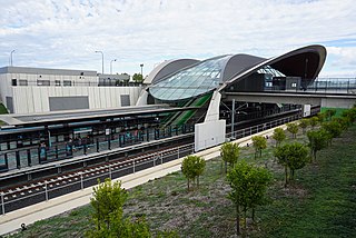
Kellyville railway station is an elevated station on the Metro North West Line, as part of the Sydney Metro network. The station was built by Impregilo-Salini and Metro Trains Sydney for Transport for NSW, and is situated along Samantha Riley Drive, Kellyville, in Sydney, Australia. Train services from the station run to Rouse Hill and Chatswood, with a journey time to Chatswood of around 33 minutes. As the New South Wales Government's Sydney's Rail Future strategy is delivered over the next 20 years, services are expected to be extended to the Sydney central business district (CBD) and Bankstown. Kellyville Station opened on 26 May 2019.

<span class="mw-page-title-main">Tallawong railway station</span> Sydney Metro railway station

Tallawong railway station, originally known as Cudgegong Road railway station, is a Sydney Metro station near the intersection of Cudgegong and Schofield Roads in Tallawong, New South Wales, Australia. The station is the terminus of the Metro North West Line on the Sydney Metro network. Beyond the station lies the Tallawong depot, where all metro rolling stock is stabled.

Caddens is a suburb of Sydney, in the state of New South Wales in Australia. It is a new masterplanned residential neighborhood located 48 kilometres west of the Sydney central business district, in the local government area of the City of Penrith featuring views of the scenic Blue Mountains. The suburb's postcode is 2747.

<span class="mw-page-title-main">Norwest, New South Wales</span> Suburb of Sydney, New South Wales, Australia

Norwest is a suburb of the Hills District within Greater Western Sydney, in the state of New South Wales, Australia, located 35 kilometres north-west of the Sydney central business district. The Norwest Business Park is located within Norwest and the adjacent suburb of Bella Vista and Baulkham Hills. The council chambers for The Hills Shire Council are also located within this suburb.

North Kellyville is a suburb of Sydney, in the state of New South Wales, Australia. It is located 37 kilometres north-west of the Sydney central business district within the local government area of The Hills Shire. The suburb falls within the Hills District.

Tallawong is a suburb of Blacktown in the state of New South Wales, Australia. Tallawong is in north-west Greater Sydney Area in the local government area of Blacktown. It is named after the metro station located within its boundaries, which opened in May 2019. Tallawong is a Darug word meaning apple gum tree.

References

  1. 1 2 Australian Bureau of Statistics (28 June 2022). "Kellyville Ridge (State Suburb)". 2021 Census QuickStats. Retrieved 15 January 2018. OOjs UI icon edit-ltr-progressive.svg
  2. "Blacktown City Council - Our suburbs". www.blacktown.nsw.gov.au. Retrieved 21 August 2021.
  3. "Merriville House & Gardens". New South Wales State Heritage Register . Department of Planning & Environment. H00091. Retrieved 18 May 2018. CC BY icon.svg Text is licensed by State of New South Wales (Department of Planning and Environment) under CC-BY 4.0 licence .
  4. "3218.0 – Regional Population Growth, Australia, 2013–14". abs.gov.au. Archived from the original on 31 May 2015.
  5. "The Ponds". shopattheponds.com.au.
  6. "Stanhope Village – Mirvac Shopping Centre". stanhopevillage.com.au.
  7. "2022 Kellyville Ridge NSW 2155 Suburb Profile & Information". irvingg. Retrieved 23 July 2022.
  8. "Google Maps".
  9. Sydney Metro is now open Transport for NSW
  10. "Sydney Metro". nwrail.transport.nsw.gov.au.
  11. "Home – The Ettamogah, Kellyville Ridge, NSW 2155". ettamogahhotel.com.au. Archived from the original on 18 June 2015.

33°42′11″S150°55′08″E / 33.703°S 150.919°E / -33.703; 150.919