Eastbound view of the former station in November 2009Eastbound view from the concourse in October 2011
Schofields station opened in 1870.[3] It was named after John Schofield, a local pioneer who was a former convict who later settled in the area after building a saw mill beside the railway line. The former station was originally opened as a siding stop with a platform made from railway sleepers in the early 1870s on the western side of the track, which was later rebuilt in brick in 1888 along with a goods loop after the Richmond line was upgraded by John Whitton, the then engineer-in-chief.[4] The history of the station and surrounding local area have been highlighted through signs placed near the entrances to both former and present station sites.
First station
The old Schofields station consisted of a single side platform with street level access on the eastern side of the track. A pedestrian level crossing to the north of the platform allowed access to the other side of the track. An interesting feature of the station was the adjacent grain and produce facility that protruded into the railway platform. The old station closed on 3 October 2011.
Current station
Background
From 2009 to 2011, the track between Quakers Hill and Schofields was duplicated for more than three kilometres as part of the Rail Clearways Program.[5] This was intended as the first stage of a broader plan to duplicate the line as far as Vineyard. In order to be able to continue the duplication towards Richmond, it was proposed re-align a short section of track and relocate Schofields station to a site with fewer space constraints, 800 metres south of the existing station. The proposal to relocate the station was a controversial one and raised concerns amongst residents and businesses located near the former station, in relation to accessibility and urban decay.[6] Despite opposition to the plans from Blacktown City Council and the government's own local representative, John Aquilina MP, construction commenced and the station opened on 29 October 2011. The new station is located in a developing area, foreseeing future residential development, and is designed to support a dramatic increase in patronage.[7]
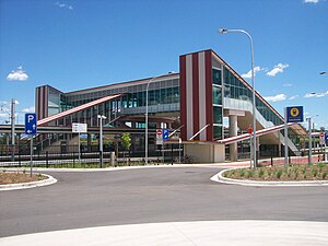
Description
The station features a distinctive colour scheme of maroon and cream as seen on the tin roofing, inspired by the station master's residence at Riverstone station and reflecting on the European heritage of the local Richmond area and consists of an island platform. The station also includes indicator screens on the platforms and network status screens indicating trackwork or service interruptions on the concourse. The station is equipped for disabled access with lifts from street level to the concourse and to the platform levels.
230 parking spaces are available at the station with 110 on the Railway Terrace side and 120 on the Bridge Street side (opened in mid December 2011), with both including disabled parking spaces. Although claimed to be three times the size of the previous station car park,[8] issues have arisen concerning the size of the area. 40 bicycle racks are available. A "kiss-and-ride" zone is located parallel to the bus interchange.[8][9] As part of the relocation, a shared pedestrian and cycling path was built between the former station to the current site and a footbridge was constructed at the site of the former station to replace the pedestrian level crossing.
Eastern side of the station in November 2011; the bus interchange is on the left, station entrance via stairs in the centre and one of the carparks on the right
During the week, T5 Cumberland Line services terminate at Schofields. Late night services throughout the week however, extend to Richmond, replacing T1 services at these times.
Stations and services in italics are planned or under construction
Stations in (parentheses) are uncommon stops for the listed service
This page is based on this Wikipedia article Text is available under the CC BY-SA 4.0 license; additional terms may apply. Images, videos and audio are available under their respective licenses.


