Lindfield railway station

Last updated

Lindfield
Lindfield Station 2018.jpg
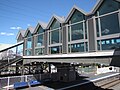
Station platforms and buildings in August 2018
General information
Location Pacific Highway, Lindfield
New South Wales
Australia
Coordinates 33°46′30″S151°10′08″E / 33.77513°S 151.16900°E / -33.77513; 151.16900 (Lindfield railway station)
Elevation102 metres (335 ft)
Owned by Transport Asset Manager of NSW
Operated by Sydney Trains
Line(s) North Shore
Distance14.60 km (9.07 mi) from Central
Platforms3 (1 side, 1 island)
Tracks3
Connections TfNSW B.svg Bus
Construction
Structure typeGround
Other information
StatusStaffed
Station code LDD
History
Opened1 January 1890(135 years ago) (1890-01-01)
ElectrifiedYes; 1927
Passengers
2023 [1]
  • 1,859,440 (year)
  • 5,094 (daily) [2] (Sydney Trains, NSW TrainLink)
Services
Preceding station TfNSW T.svg Sydney Trains Following station
Roseville
towards Emu Plains or Richmond
North Shore & Western Line Killara
towards Berowra
Roseville
via Strathfield
towards Hornsby
Northern Line Killara
towards Gordon
Location
Lindfield railway station

Lindfield railway station is a suburban railway station located on the North Shore line, serving the Sydney suburb of Lindfield. It is served by Sydney Trains T1 North Shore Line and T9 Northern Line services.

Contents

History

Lindfield station opened on 1 January 1890 when the North Shore line opened from Hornsby to St Leonards. [3] It was named after a house near the station, between Bent and Balfour Streets, was named "Lindfield" after the native town of Mr. List, the owner. Mr. William Cowan, first President of the Shire, afterwards lived there.

By 1900, the line south of Lindfield had been duplicated with the platform converted to an island platform, this was extended north in 1909. By 1922, a new side platform had been opened on the eastern side, with the middle platform becoming a terminating road. [4]

The station was upgraded with a new concourse and lifts constructed in 2009.

Services

Platforms

PlatformLineStopping patternNotes
1services to Penrith, Emu Plains & Richmond via Central [5]
T9
services to Hornsby via Strathfield
2
T1
terminating services to/from Penrith & Richmond
3
T1
services to Gordon, Hornsby & Berowra
T9
services to Gordon

Lindfield Station is served by three bus routes operated by CDC NSW and one NightRide route. [6]

Trackplan

Lindfield
↑N to Killara
TfNSW T1.svg
TfNSW T9.svg
Station
Concourse
BSicon MFADEg.svg
BSicon vSTR- saffron.svg
BSicon MFADEg.svg
BSicon vSTR- saffron.svg
BSicon MFADEg.svg
BSicon vSTR- red.svg
BSicon MFADEg.svg
BSicon vSTR- red.svg
↑to buses
BSicon vSTR- saffron.svg
BSicon vSTR- red.svg
BSicon MFADEgq.svg
BSicon -STRq.svg
BSicon -STRfq.svg
BSicon -STR2+r.svg
BSicon -STRq.svg
BSicon STRc3.svg
BSicon -SHI2lq.svg
BSicon STRq-PLT.svg
BSicon XPLT.svg
BSicon STRq-PLT.svg
Platform
BSicon STRq-PLT.svg
BSicon STRq-PLT.svg
BSicon STRq-PLT.svg
3↑
BSicon STRq-PLT.svg
BSicon STRq-PLT.svg
BSicon STRq-PLT.svg
BSicon SHI2rq-.svg
BSicon -STRq.svg
BSicon -STRfq.svg
BSicon MFADEfq.svg
BSicon -STRq.svg
BSicon vSTR- saffron.svg
BSicon vKBHFa-L saffron.svg
BSicon vBHF-R- saffron.svg
BSicon BHF-L red.svg
BSicon BHF-R red.svg
BSicon MFADEgq.svg
BSicon -STRq.svg
BSicon -STRgq.svg
BSicon -STR2+r.svg
BSicon STRc1.svg
BSicon -STRq.svg
BSicon -STRl+4.svg
BSicon STRc3.svg
BSicon -STRq.svg
BSicon PLT-STRq.svg
BSicon XPLT.svg
BSicon PLT-STRq.svg
BSicon PLT-STRq.svg
Platform
BSicon PLT-STRq.svg
BSicon PLT-STRq.svg
BSicon PLT-STRq.svg
2↓
BSicon PLT-STRq.svg
BSicon PLT-STRq.svg
BSicon -ENDEeq.svg
BSicon STRc2.svg
BSicon ex-ENDEaq.svg
BSicon -STR3+l.svg
BSicon ex-STRq.svg
BSicon -STRgq.svg
BSicon MFADEfq.svg
BSicon -STRq.svg
BSicon v-SHI2r saffron.svg
BSicon v-SHI2l saffron.svg
BSicon vSTR- saffron.svg
BSicon vSHI2+r- saffron.svg
BSicon vSTR- saffron.svg
BSicon vSTR- red.svg
BSicon STRc1.svg
BSicon STRl+4-.svg
BSicon -PLT.svg
BSicon STRq-.svg
BSicon STRq-.svg
BSicon XPLT.svg
BSicon -PLT.svg
BSicon STRq-.svg
BSicon -PLT.svg
BSicon STRq-.svg
BSicon -PLT.svg
BSicon STRq-.svg
Platform
BSicon -PLT.svg
BSicon STRq-.svg
BSicon -PLT.svg
BSicon STRq-.svg
BSicon -PLT.svg
BSicon -PLT.svg
1↑
BSicon STRq-.svg
BSicon STRr+1-.svg
BSicon STRc4.svg
BSicon vNULgf.g.svg
BSicon vSTR- saffron.svg
BSicon vNULfg.g.svg
BSicon vSTR- saffron.svg
BSicon vNULgf.g.svg
BSicon vSTR- red.svg
BSicon vNULfg.g.svg
BSicon vSTR- red.svg
↓to buses
BSicon MFADEf.svg
BSicon vSTR- saffron.svg
BSicon MFADEf.svg
BSicon vSTR- saffron.svg
BSicon MFADEf.svg
BSicon vSTR- red.svg
BSicon MFADEf.svg
BSicon vSTR- red.svg
plt
3 2 1
3   1
↓S to Roseville

References

  1. "Train Station Monthly Usage". Open Data. Retrieved 26 January 2024.
  2. This figure is the number of entries and exits of a year combined averaged to a day.
  3. Lindfield Station NSWrail.net
  4. Lindfield Railway Station Group NSW Environment & Heritage
  5. "T1: North Shore line timetable". Transport for NSW.
  6. Lindfield Station Transport for NSW