| Carcoar Dam | |
|---|---|
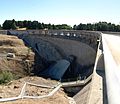
 Carcoar Dam, 2007 | |
 The location of the Carcoar Dam in New South Wales | |
| Location | Carcoar, New South Wales, Australia |
| Coordinates | 33°37′00″S149°10′45″E / 33.61667°S 149.17917°E |
| Purpose | Irrigation, water supply, and water conservation |
| Status | Operational |
| Construction began | 1969 |
| Opening date | 1970 |
| Owner(s) | State Water Corporation |
| Dam and spillways | |
| Type of dam | Arch dam |
| Impounds | Belubula River |
| Height | 52 metres (171 ft) |
| Length | 187 metres (614 ft) |
| Dam volume | 61 cubic metres (2,200 cu ft) |
| Spillways | 1 |
| Spillway type | Uncontrolled overflow spillway |
| Spillway capacity | 1,218 cubic metres per second (43,000 cu ft/s) |
| Reservoir | |
| Total capacity | 36,400 megalitres (1,290×106 cu ft) |
| Catchment area | 230 square kilometres (89 sq mi) |
| Surface area | 385 hectares (950 acres) |
| Maximum water depth | 41 metres (135 ft) |
| Normal elevation | 720 metres (2,360 ft) AHD |
| Website Carcoar Dam at www.statewater.com.au | |
Carcoar Dam is a minor ungated concrete double parabolic arch dam with an uncontrolled overflow spillway across the Belubula River upstream of Carcoar in the central west region of New South Wales, Australia. The dam's purpose includes irrigation, water supply, and water conservation.