Chaffey Dam

Last updated

Chaffey Dam
Chaffey dam spillway.JPG
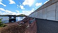
Chaffey Dam (pre upgrade) at 77% capacity, in 2008.
Australia New South Wales relief location map.png
Red pog.svg
Location of Chaffey Dam in
New South Wales
Location Tamworth, New South Wales, Australia
Coordinates 31°20′45″S151°08′19″E / 31.34583°S 151.13861°E / -31.34583; 151.13861
Purpose Flood mitigation, irrigation, water supply, and water conservation
StatusOperational
Construction beganAugust 1976 (1976-08)
Opening dateSeptember 1979 (1979-09)
Owner(s)State Water Corporation
Dam and spillways
Type of dam Embankment dam
Impounds Peel River
Height55.8 metres (183 ft)
Length430 metres (1,410 ft)
Width (crest)8 metres (26 ft)
Width (base)195 metres (640 ft)
Dam volume1,413 cubic metres (49,900 cu ft)
Spillways 1
Spillway type Morning glory
Spillway capacity903 cubic metres per second (31,900 cu ft/s)
Reservoir
Total capacity102,868 megalitres (3,632.7×10^6 cu ft)
Catchment area 420 square kilometres (160 sq mi)
Surface area542 hectares (1,340 acres)
Maximum water depth30 metres (98 ft)
Normal elevation518 metres (1,699 ft) AHD
Website
Chaffey Dam at www.waternsw.com.au

Chaffey Dam is a minor ungated rock fill with clay core embankment dam with an uncontrolled morning glory spillway across the Peel River, located upstream of the city of Tamworth, in the New England region of New South Wales, Australia. The dam's purpose includes flood mitigation, irrigation, water supply, and water conservation.

Contents

Location and features

Commenced in August 1976 and completed in September 1979, the Chaffey Dam is a minor dam on the Peel River, a tributary of the Namoi River, approximately 16 kilometres (9.9 mi) north of Nundle and 44 kilometres (27 mi) south-east of Tawmorth. [1] Water from the dam is released directly into the Peel River which is used by irrigators downstream of the dam, and for water supply of the city of Tamworth. [2]

The dam wall comprises 1,413 cubic metres (49,900 cu ft) of rock fill is 55.8 metres (183 ft) high and is 430 metres (1,410 ft) long. The maximum water depth is 30 metres (98 ft) and at 100% capacity the dam wall holds back 62,830 megalitres (2,219×10^6 cu ft) of water at 518 metres (1,699 ft) AHD. The surface area of the reservoir is 542 hectares (1,340 acres) and the catchment area is 420 square kilometres (160 sq mi).

The dam uses an unusual concrete morning glory bell-shaped uncontrolled spillway which is capable of discharging 903 cubic metres per second (31,900 cu ft/s). [2] [3] [4] The spillway measures 25.81 metres (84.7 ft) in diameter and tapers down to 7.72 metres (25.3 ft). The spillway tower is 35.1 metres (115 ft) high.[ citation needed ]

Chaffey Dam provides valuable public recreation including swimming, sailing, boating and fishing. [2]

Upgrade of facilities

An A$13 million upgrade of Chaffey Dam commenced during 2010 that involved the construction of a 35 metres (115 ft) auxiliary spillway with release plug, funded by the Government of New South Wales and was completed in early 2011. [5] A second stage A$43.33 million augmentation commenced in 2013, funded by the Australian Government, the NSW Government and Tamworth Regional Council. This augmentation is expected to be completed during 2014 and involves raising the dam wall by 8 metres (26 ft) and subsequent works to raise the morning glory spillway and bridge deck. These works will increase the full supply level of the dam by 6.5 metres (21 ft), the dam's capacity from 62 gigalitres (2.2×10⁹ cu ft) to 100 gigalitres (3.5×10⁹ cu ft) and ensure it can withstand the maximum possible flood. The project also involves a realignment of roads on the western foreshore; the Tamworth-Nundle Road, and River Road. [6]

Etymology

The dam is named in honor of Frank Chaffey, [1] who represented Tamworth in the New South Wales Legislative Assembly between 1913 and 1940, and his son, Bill, [1] who represented the same seat between 1940 and 1973.

See also

Related Research Articles

<span class="mw-page-title-main">Warragamba Dam</span> Dam in Warragamba, New South Wales

Warragamba Dam is a heritage-listed dam in the outer South Western Sydney suburb of Warragamba, Wollondilly Shire in New South Wales, Australia. It is a concrete gravity dam, which creates Lake Burragorang, the primary reservoir for water supply for the city of Sydney. The dam wall is located approximately 65 kilometres (40 mi) W of Sydney central business district, 4½ km SW of the town of Wallacia, and 1 km NW of the village of Warragamba.

<span class="mw-page-title-main">Glenbawn Dam</span> Dam in Hunter Valley, New South Wales

Glenbawn Dam is a major ungated earth and rock fill with clay core embankment dam with concrete chute spillway plus fuse plugs across the Hunter River upstream of Aberdeen in the Hunter Valley of New South Wales, Australia. The dam's purpose includes flood mitigation, hydro-electric power, irrigation, water supply and conservation. The impounded reservoir is called Lake Glenbawn.

<span class="mw-page-title-main">Keepit Dam</span> Dam in North West Slopes, New South Wales

Keepit Dam is a major gated mass concrete gravity dam with an earth fill abutment and a central gated concrete overflow crest and six radial gate spillways across the Namoi River upstream of its junction with the Peel River in the North West Slopes region of New South Wales, Australia. The dam's purpose includes flood mitigation, hydro-power, irrigation, water supply and conservation. The impounded reservoir is called Lake Keepit.

<span class="mw-page-title-main">Peel River (New South Wales)</span> River in New South Wales, Australia

Peel River, a watercourse that is part of the Namoi catchment within the Murray–Darling basin, is located in the North West Slopes and Plains district of New South Wales, Australia.

<span class="mw-page-title-main">Wyangala Dam</span> Dam in New South Wales, Australia

Wyangala Dam is a major gated rock fill with clay core embankment and gravity dam with eight radial gates and a concrete chute spillway across the Lachlan River, located in the south-western slopes region of New South Wales, Australia. The dam's purpose includes flood mitigation, hydro-power, irrigation, water supply and conservation. The impounded reservoir is called Lake Wyangala.

<span class="mw-page-title-main">Glennies Creek Dam</span> Dam in New South Wales

Glennies Creek Dam is a minor ungated concrete faced curved earth and rockfill embankment dam with an uncontrolled rock cut spillway across the Glennies Creek, upstream of Singleton, in the Hunter region of New South Wales, Australia. The dam's purpose includes flood mitigation, irrigation, water supply and conservation. The impounded reservoir is called Lake Saint Clair.

<span class="mw-page-title-main">Copeton Dam</span> Dam in New South Wales, Australia

Copeton Dam is a major clay core and rock fill embankment dam with nine radial gates and a gated concrete chute spillway across the Gwydir River upstream of Bingara in the New England region of New South Wales, Australia. The dam's purpose includes environmental flows, hydro-electric power generation, irrigation, and water supply. The impounded reservoir is called Lake Copeton.

Windamere Dam is a minor ungated rock fill with clay core embankment dam with an uncontrolled unlined rock cutting spillway across the Cudgegong River at Cudgegong, upstream of Mudgee in the Central Tablelands of New South Wales, Australia. The dam's purpose includes hydro-power, irrigation, water supply, and conservation. The impounded reservoir is called Lake Windamere.

<span class="mw-page-title-main">Blowering Dam</span> Dam in Snowy Mountains, New South Wales

The Blowering Dam is a major ungated rock fill with clay core embankment dam with concrete chute spillway impounding a reservoir under the same name. It is located on the Tumut River upstream of Tumut in the Snowy Mountains region of New South Wales, Australia. Purposes for the dam include flood mitigation, hydro-power, irrigation, water supply and conservation. The dam is part of the Snowy Mountains Scheme, a vast hydroelectricity and irrigation complex constructed in south-east Australia between 1949 and 1974 and now run by Snowy Hydro.

<span class="mw-page-title-main">Split Rock Dam</span> Dam in North West Slopes, New South Wales

Split Rock Dam is a minor ungated concrete faced rock fill embankment dam with concrete chute spillway across the Manilla River upstream of Manilla in the north-western slopes region of New South Wales, Australia. The dam's purpose includes flood mitigation, irrigation, water supply and conservation. The impounded reservoir is called Split Rock Reservoir.

Pindari Dam is a minor concrete faced rockfill embankment dam with an ungated uncontrolled rock cut with concrete sill spillway across the Severn River located upstream of the town of Ashford, in the North West Slopes region of New South Wales, Australia. The dam's purpose includes flood mitigation, hydro-power, irrigation, water supply and conservation. The impounded reservoir is called Lake Pindari.

<span class="mw-page-title-main">Warragamba River</span> River in New South Wales, Australia

The Warragamba River, a river that is part of the Hawkesbury-Nepean catchment, is located in the Macarthur region of New South Wales, Australia.

<span class="mw-page-title-main">Clarrie Hall Dam</span> Dam in New South Wales, Australia

Clarrie Hall Dam is a minor ungated concrete faced rockfill embankment dam with an uncontrolled concrete-lined chute spillway across the Doon Doon Creek, located upstream of the small town of Uki, in the Northern Rivers region of New South Wales, Australia. The main purpose of the dam is for water supply and it creates the artificial Lake Clarrie Hall.

<span class="mw-page-title-main">Toonumbar Dam</span> Dam in Northern Rivers, New South Wales

Toonumbar Dam is a minor ungated rock fill with clay core embankment dam with a concrete chute spillway across the Iron Pot Creek north-west of Casino in the Northern Rivers region of New South Wales, Australia. The dam's purpose includes hydro-power, irrigation, water supply, and conservation. The impounded reservoir is called Lake Toonumbar.

<span class="mw-page-title-main">Cotter Dam</span> Dam in Australian Capital Territory, Australia

The Cotter Dam is a concrete gravity and rockfill embankment dam across the Cotter River, located in the Australian Capital Territory, Australia. Both the dam and river are named after early settler in the area Garrett Cotter. The impounded Cotter Reservoir is a supply source of potable water for the city of Canberra and its environs.

<span class="mw-page-title-main">Ben Chifley Dam</span> Dam in Central West, New South Wales

Ben Chifley Dam, or Chifley Dam, is a rock and earth-fill embankment dam across the Campbells River in the central west region of New South Wales, Australia. The main purpose of the dam is to supply potable water to the city of Bathurst.

<span class="mw-page-title-main">Carcoar Dam</span> Dam in New South Wales, Australia

Carcoar Dam is a minor ungated concrete double parabolic arch dam with an uncontrolled overflow spillway across the Belubula River upstream of Carcoar in the central west region of New South Wales, Australia. The dam's purpose includes irrigation, water supply, and water conservation.

<span class="mw-page-title-main">Oberon Dam</span> Dam in Central Tablelands, New South Wales

Oberon Dam or Fish River Dam is a major ungated concrete slab and buttress with earth embankment dam comprising a concrete ski jump chute spillway and fuse plug across the Fish River upstream of Oberon in the Central Tablelands region of New South Wales, Australia. The dam's purpose includes flood mitigation, industrial, and water supply. The impounded reservoir is called Lake Oberon.

Rydal Dam is a minor ungated homogeneous earthfill embankment dam with a fuse plug uncontrolled open channel spillway across an off stream storage, located near Rydal in the Central Tablelands region of New South Wales, Australia. The dam's purpose is to provide water storage for Delta power stations at Wallerawang and Mount Piper. The impounded reservoir is also called the Rydal Dam.

Brogo Dam is a minor ungated rockfill embankment dam with an uncontrolled unlined rock cut spillway across the Brogo River upstream of Brogo in the South Coast region of New South Wales, Australia. The dam's purpose includes environmental flows, hydro-electric power generation, irrigation, and water supply. The impounded reservoir is also called Brogo Dam.

References

  1. 1 2 3 "Chaffey Dam". Geographical Names Register (GNR) of NSW. Geographical Names Board of New South Wales . Retrieved 14 April 2013. OOjs UI icon edit-ltr-progressive.svg
  2. 1 2 3 "Chaffey Dam" (PDF). State Water Corporation. 2009. Archived from the original (PDF brochure) on 20 March 2012. Retrieved 14 April 2013.
  3. "Chaffey Dam". Water delivery: Dams. State Water Corporation. Archived from the original on 10 April 2013. Retrieved 14 April 2013.
  4. "Register of Large Dams in Australia" (Excel (requires download)). Dams information. The Australian National Committee on Large Dams Incorporated. 2010. Retrieved 22 April 2013.
  5. "Chaffey upgrade". Projects: Dam safety upgrades. State Water Corporation. Archived from the original on 10 April 2013. Retrieved 14 April 2013.
  6. "Chaffey Dam augmentation". Projects: Dam safety upgrades. State Water Corporation. Archived from the original on 10 April 2013. Retrieved 14 April 2013.