Bilgola Beach, New South Wales

Last updated • 2 min readFrom Wikipedia, The Free Encyclopedia

Bilgola Beach
Sydney,  New South Wales
Bilgola Surf Livesaving Club.JPG
Bilgola Surf Lifesaving Club
Bilgola Beach, New South Wales
Population251 (SAL 2021) [1]
Elevation14 m (46 ft)
Location33 km (21 mi) north-east of Sydney CBD
LGA(s) Northern Beaches Council
State electorate(s) Pittwater
Federal division(s) Mackellar
Suburbs around Bilgola Beach:
Avalon Beach Avalon Beach
Bilgola Plateau Bilgola Beach Tasman Sea
Newport Newport

Bilgola Beach is a suburb in Sydney's Northern Beaches in the state of New South Wales, Australia. Bilgola Beach is 33 kilometres north-east of the Sydney central business district, in the local government area of Northern Beaches Council. It and Bilgola Plateau were gazetted as suburbs in 2012, dividing the previous suburb of Bilgola.

Contents

Location

Bilgola Beach is located on the Tasman Sea side of the Barrenjoey Peninsula between Avalon Beach to the north and Newport to the south. The landscape rises steeply behind Bilgola Beach to Bilgola Plateau, descending to Clareville on the western side of the peninsula.

History

The name "Bilgola" is derived from an Aboriginal term Belgoula meaning "swirling waters", or perhaps "a pretty beach with steep slopes, studded with cabbage palms". [2] The word Belgoula was noted in Surveyor James Meehan's records of 1814. Robert Henderson received a grant of 100 acres (0.40 km2) in 1822 which he named "Belgoola". The district eventually adopted the simplified name "Bilgola". [3]

The area was owned by the McLurcan family from the start of the early 1900s. Mrs McLurcan was famous for her cookery book, 'Mrs McLurcan's Cookery Book'. The large family home was surrounded by cabbage tree palms, for which the area is noted.

There were plans during the 1960s to build a bridge bypass of the twisting road ('Bilgola Bends') between the north and south headlands of Bilgola. The bridge was not built but a small amount of landfill was added to remove a sharp bend in the southern end of the road in preparation for construction. The bend still remains, with the landfill now providing a small grassy area, with an excellent view of Newport Beach.

Demographics

According to the 2021 census of Population, there were 251 residents in Bilgola Beach. 69.3% of people were born in Australia. The most common other countries of birth were England 8.8%, New Zealand 3.6%, South Africa 2.4%, Germany 1.6% and Netherlands 1.6%. 89.2% of people only spoke English at home. Other languages spoken at home included French 2.8%, Dutch 1.2% and Arabic 1.2%. The most common responses for religion in Bilgola were No Religion 51.8%, Catholic 17.9% and Anglican 14.3%. [4]

Transport

The main road connecting the northern part of the Barrenjoey Peninsula to the rest of Sydney, Barrenjoey Road, runs through Hewitt Park along the cliff line between Bilgola headland and Bilgola South headland. The road separates Bilgola Plateau from Bilgola Beach.

Sport and recreation

Bilgola Surf Life Saving Club is located at Bilgola Beach. It was formed in the summer of 1949 with construction of the club house beginning in 1950. [5]

Avalon Bilgola Amateur Swimming Club swims at the Bilgola Rock Pool on Saturday mornings during the summer months. The club was formed in 1961.

Related Research Articles

<span class="mw-page-title-main">Palm Beach, New South Wales</span> Suburb of Sydney, New South Wales, Australia

Palm Beach is a suburb in the Northern Beaches region of Greater Sydney, in the state of New South Wales, Australia. Palm Beach is located 41 kilometres (25 mi) north of the Sydney central business district, in the local government area of Northern Beaches Council. Palm Beach sits on a peninsula at the end of Barrenjoey Road near Pittwater and is the northernmost beach in the Greater Sydney Metropolitan area. The population of Palm Beach was 1,593 as at the 2016 census.

<span class="mw-page-title-main">Northern Beaches</span> Region in New South Wales, Australia

The Northern Beaches is a region within Northern Sydney, in the state of New South Wales, Australia, near the Pacific coast. This area extends south to the entrance of Port Jackson, west to Middle Harbour and north to the entrance of Broken Bay. The area was formerly inhabited by the Garigal or Caregal people in a region known as Guringai country.

<span class="mw-page-title-main">Avalon Beach, New South Wales</span> Suburb of Sydney, New South Wales, Australia

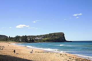
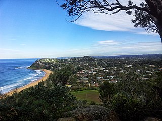
Avalon Beach is a northern beachside suburb of Sydney, in the state of New South Wales, Australia. It is 28 kilometres north of the Sydney central business district, in the local government area of Northern Beaches Council, in the Northern Beaches region. The area was previously called Avalon, with the name Avalon Beach being assigned during a change in boundaries and names in the Pittwater region in 2012.

<span class="mw-page-title-main">Pittwater Council</span> Former local government area in New South Wales, Australia

Pittwater Council was a local government area on the Northern Beaches of Sydney, in the state of New South Wales, Australia. It covered a region adjacent to the Tasman Sea about 30 kilometres (19 mi) north of the Sydney central business district. The area is named after Pittwater, the body of water adjacent to much of the area governed. First proclaimed in 1906 as the A Riding of Warringah Shire, the area was proclaimed as the Municipality of Pittwater on 1 May 1992. On 12 May 2016, the Minister for Local Government announced that Pittwater Council would be subsumed into the newly formed Northern Beaches Council. The last mayor of Pittwater Council was Councillor Jacqui Townsend, an independent politician.

<span class="mw-page-title-main">Coogee, New South Wales</span> Suburb of Sydney, Australia

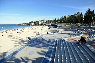
Coogee is a beachside suburb in the Eastern Suburbs of Sydney, New South Wales, Australia, eight kilometres south-east of the Sydney central business district.

<span class="mw-page-title-main">Collaroy, New South Wales</span> Suburb of Sydney, New South Wales, Australia

Collaroy is a suburb in northern Sydney, in the state of New South Wales, Australia. Collaroy is 22 kilometres north-east of the Sydney central business district, in the local government area of Northern Beaches Council. It is part of the Northern Beaches region. Nicknamed "The Roy" by many of the locals.

<span class="mw-page-title-main">Division of Mackellar</span> Australian federal electoral division

The Division of Mackellar is an Australian electoral division in the state of New South Wales.

Barrenjoey High School is a government-funded co-educational comprehensive secondary day school, located in Avalon Beach, a suburb in the Northern Beaches of Sydney, New South Wales, Australia.

<span class="mw-page-title-main">Queenscliff, New South Wales</span> Suburb of Sydney, New South Wales, Australia

Queenscliff is a suburb of northern Sydney, in the state of New South Wales, Australia. Queenscliff is located 16 kilometres north-east of the Sydney central business district, in the local government area of Northern Beaches Council and is part of the Northern Beaches region.

<span class="mw-page-title-main">North Curl Curl, New South Wales</span> Suburb of Sydney, New South Wales, Australia

North Curl Curl is a suburb in northern Sydney, in the state of New South Wales, Australia 19 kilometres north-east of the Sydney central business district, in the local government area of Northern Beaches Council. It is part of the Northern Beaches region.

<span class="mw-page-title-main">Newport, New South Wales</span> Suburb of Northern Beaches Council, New South Wales, Australia

Newport is a suburb of northern Sydney in the state of New South Wales, Australia, in the local government area of Northern Beaches Council. It is part of the Northern Beaches region.

<span class="mw-page-title-main">Malabar, New South Wales</span> Suburb of Sydney, New South Wales, Australia

Malabar is a suburb in the Eastern Suburbs of Sydney, in the state of New South Wales, Australia 12 kilometres south-east of the Sydney central business district, in the local government area of the City of Randwick.

<span class="mw-page-title-main">Tamarama</span> Suburb of Sydney, New South Wales, Australia

Tamarama is a beachside suburb, eastern suburb of Sydney, in the state of New South Wales, Australia. Tamarama is 6 kilometres east of the Sydney central business district, in the local government area of Waverley Council.

<span class="mw-page-title-main">Bilgola Plateau, New South Wales</span> Suburb of Sydney, New South Wales, Australia

Bilgola Plateau is a suburb in Sydney's Northern Beaches in the state of New South Wales, Australia.

<span class="mw-page-title-main">Clareville, New South Wales</span> Suburb of Sydney, New South Wales, Australia

Clareville is a suburb in northern Sydney, in the state of New South Wales, Australia. Clareville is 36 kilometres north-east of the Sydney central business district, in the local government area of Northern Beaches Council. Clareville is part of the Northern Beaches region.

<span class="mw-page-title-main">Umina Beach, New South Wales</span> Suburb of Central Coast, New South Wales, Australia

Umina Beach is a suburb within the Central Coast Council local government area on the Central Coast of New South Wales, Australia. Umina Beach is situated 85 kilometres (53 mi) north of Sydney and 111 kilometres (69 mi) south of Newcastle.

<span class="mw-page-title-main">Barrenjoey Road</span> Road in Sydney, Australia

Barrenjoey Road is a main urban road along the northern coast of the Northern Beaches suburbs of Sydney, Australia. In 1978, the Barrenjoey Road area came to national attention due to the unsolved disappearance of Trudie Adams.

<span class="mw-page-title-main">Freshwater, New South Wales</span> Suburb of Sydney, New South Wales, Australia

Freshwater is a suburb of northern Sydney, in the state of New South Wales, Australia. Freshwater is located 17 kilometres (11 mi) north-east of the Sydney central business district, in the local government area of Northern Beaches Council and is part of the Northern Beaches region.

<span class="mw-page-title-main">Sydney bus route 190X</span> Bus service in Sydney, Australia

190X is a peak-hour express bus service operated by Keolis Downer Northern Beaches between Avalon and Wynyard station. The route and its predecessors are well known for its ocean scenery along the journey and have been popular with hikers planning to walk from Palm Beach back towards Sydney. For many years the route was also the longest commuter bus route in metropolitan Sydney at 45 kilometres (28 mi) when operating from Palm Beach. In March 2013 Australian diecast model company Transit Graphics released a 1:76 scale model of a Mercedes-Benz O305 bus operating on route L90.

<span class="mw-page-title-main">Northern Beaches Council</span> Local government area in New South Wales, Australia

The Northern Beaches Council is a local government area located in the Northern Beaches region of Sydney, in the state of New South Wales, Australia. The council was formed on 12 May 2016 after the amalgamation of Manly, Pittwater, and Warringah councils.

References

  1. Australian Bureau of Statistics (28 June 2022). "Bilgola Beach (suburb and locality)". Australian Census 2021 QuickStats. Retrieved 28 June 2022.  OOjs UI icon edit-ltr-progressive.svg
  2. "id.com.au". Archived from the original on 26 September 2007. Retrieved 7 September 2007.
  3. The Book of Sydney Suburbs, Compiled by Frances Pollon, Angus & Robertson Publishers, 1990, Published in Australia ISBN   0-207-14495-8, page 29
  4. Australian Bureau of Statistics (28 June 2022). "Bilgola (State Suburb)". 2021 Census QuickStats. Retrieved 5 August 2024. OOjs UI icon edit-ltr-progressive.svg
  5. "Bilgola Surf Life Saving Club". Archived from the original on 31 March 2019. Retrieved 26 July 2007.

33°38′44″S151°19′04″E / 33.64565°S 151.31782°E / -33.64565; 151.31782