
Miranda is a suburb in southern Sydney, in the state of New South Wales, Australia. The suburb is known as a commercial centre for the southern suburbs. Miranda is 24 kilometres south of the Sydney central business district, in the Sutherland Shire.

Bundeena is a village and suburb on the outskirts of southern Sydney, in the state of New South Wales, Australia. Bundeena is located 29 kilometres south of the Sydney central business district and is part of the local government area of the Sutherland Shire.

Caringbah is a suburb in Southern Sydney, in the state of New South Wales, Australia. Caringbah is 24 kilometres (15 mi) south of the Sydney central business district in the local government area of Sutherland Shire.

Gymea is a suburb in southern Sydney, in the state of New South Wales, Australia. Gymea is located 26 kilometres south of the Sydney central business district in the local government area of the Sutherland Shire. The postcode is 2227, which it shares with adjacent suburb Gymea Bay.

Sutherland is a suburb in southern Sydney, in the state of New South Wales, Australia. Sutherland is located 26 kilometres south of the Sydney central business district and is the administrative centre for the local government area of the Sutherland Shire.

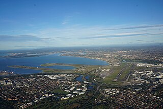
Sutherland Shire is a local government area in the southern region of Sydney, in the state of New South Wales, Australia. The Sutherland Shire is located south of the Sydney CBD, and comprises an area of 370 square kilometres (140 sq mi) and as at the 2016 census and has an estimated population of 218,464. The Sutherland Shire is colloquially known as "The Shire" which has been featured in several reality television series.
Southern Sydney is the southern metropolitan area of Greater Sydney, in the state of New South Wales, Australia.

Cronulla is a suburb of Sydney, in the state of New South Wales, Australia. Boasting numerous surf beaches and swimming spots, the suburb attracts both tourists and Greater Sydney residents. Cronulla is 26 kilometres south of the Sydney central business district, in the local government area of the Sutherland Shire.

Alfords Point is a suburb in southern Sydney, in the state of New South Wales, Australia. Alfords Point is 28 kilometres south of the Sydney central business district, within the local government area of the Sutherland Shire. Alfords Point shares the postcode of 2234 with neighbouring suburbs of Menai, Bangor and Illawong.

Yowie Bay is a suburb in southern Sydney, in the state of New South Wales, Australia. Yowie Bay is located 24 kilometres south of the Sydney central business district, in the local government area of the Sutherland Shire.

Barden Ridge is a suburb in southern Sydney, in the state of New South Wales, Australia. Barden Ridge is located 29 kilometres south of the Sydney central business district in the local government area of the Sutherland Shire. Barden Ridge is colloquially known to locals as 'The Ridge'.

Burraneer is a bayside suburb in southern Sydney, in the state of New South Wales, Australia. Burraneer is 26 kilometres south of the Sydney central business district, in the local government area of the Sutherland Shire.

The locality and suburb of Gymea Bay are located in southern Sydney, in the state of New South Wales, Australia. Gymea Bay is 27 kilometres (17 mi) south of the Sydney central business district, in the local government area of the Sutherland Shire. The postcode is 2227, which it shares with the adjacent suburb of Gymea. The Gymea Bay locality takes its name from the adjoining Gymea Bay, a small bay on the north side of the Port Hacking estuary).

Dolans Bay is a bayside suburb in Southern Sydney, in the state of New South Wales, Australia, that is located 26 kilometres (16 mi) south of the Sydney central business district, in the local government area of the Sutherland Shire.

Bonnet Bay is a suburb in southern Sydney, in the state of New South Wales, Australia that is located 29 kilometres (18 mi) south of the Sydney central business district in the local government area of the Sutherland Shire. Its postcode is 2226, which it shares with neighbouring Jannali and Como. Bonnet Bay is located on the eastern bank of the Woronora River, which flows north into the Georges River.

The Shire of Corrigin is a local government area in the Wheatbelt region of Western Australia, about 230 kilometres (143 mi) east of the state capital, Perth. Its seat of government is the town of Corrigin. The shire covers an area of 3,095 square kilometres (1,195 sq mi) and the economy, worth approximately $50 million per year to the state economy, is based on agriculture - predominantly cereal grains and sheep, with some supporting industries including a flour mill.

The Shire of York is a local government area in the Wheatbelt region of Western Australia, covering an area of 2,133 square kilometres (824 sq mi) just beyond the eastern fringe of Perth's metropolitan area. The Shire's seat of government is the town of York.

The Shire of Quairading is a local government area in the Wheatbelt region of Western Australia, about 170 kilometres (106 mi) east of the state capital, Perth. The Shire covers an area of 2,018 square kilometres (779 sq mi), and its seat of government is the town of Quairading.

The Shire of Capel is a local government area in the South West region of Western Australia, taking in the land between the cities of Bunbury and Busselton about 200 kilometres (124 mi) south of the state capital, Perth. The Shire covers an area of 557.6 square kilometres (215.3 sq mi), and its seat of government is the town of Capel.

Greenhills Beach is an unpatrolled beach on Bate Bay, located in Greenhills Beach, Sydney, New South Wales, Australia. The beach is located roughly 18 kilometres from the Sydney central business district, in the local government area of the Sutherland Shire. Recognised as one of Sydney's longest beaches, Greenhills beach is roughly 3 kilometres in length and forms part of a chain of beaches residing on Bate Bay. It is the northernmost section of the Greenhills-North Cronulla beach complex and is the only section of the beach not to be patrolled by a Surf Club or by volunteer lifesavers.


