Lilli Pilli, New South Wales

Last updated

Lilli Pilli
Sydney,  New South Wales
Lilli Pilli 1.JPG
Lilli Pilli Point
Location map Australia Sydney.png
Red pog.svg
Lilli Pilli
Lilli Pilli, New South Wales
Coordinates 34°04′06″S151°06′57″E / 34.06833°S 151.11583°E / -34.06833; 151.11583
Population1,390 (2016 census) [1]
 • Density1,540/km2 (4,000/sq mi)
Postcode(s) 2229
Elevation35 m (115 ft)
Area0.9 km2 (0.3 sq mi)
Location26 km (16 mi) south of Sydney CBD
LGA(s) Sutherland Shire
State electorate(s) Cronulla
Federal division(s) Cook
Suburbs around Lilli Pilli:
Yowie Bay Caringbah Dolans Bay
Caringbah South Lilli Pilli Port Hacking
Warumbul Royal National Park Maianbar
Lilli Pilli shops Lilli Pilli shops.jpg
Lilli Pilli shops
Lilli Pilli kindergarten Lilli Pilli kindergarten.jpg
Lilli Pilli kindergarten

Lilli Pilli is a small suburb in southern Sydney, in the state of New South Wales, Australia. Lilli Pilli is located 26 kilometres south of the Sydney central business district, in the local government area of the Sutherland Shire.

Contents

History

Lilli Pilli was named for the lilly pilly, the native myrtle that grew on the point. Thomas Holt (1811–88) owned most of the land that stretched from Sutherland to Cronulla, including land on the point. In 1840, parish maps also showed that 20 acres (8.1 ha) of land on the point were owned by Francis Mitchell. The public school opened in 1957, and celebrated its 50th anniversary in 2007. [2]

Geography

Lilli Pilli is located on the north shore of the Port Hacking estuary. The only adjacent suburbs are Caringbah South, Port Hacking and Dolans Bay. The villages of Maianbar and Bundeena are located on the opposite bank of Port Hacking.

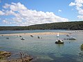
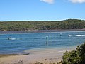
Lilli Pilli is surrounded by Gannons Bay, Little Turriel Bay, Port Hacking River and Great Turriel Bay. Lilli Pilli Point is situated at the end of Lilli Pilli Point Road, off Port Hacking Road. Lilli Pilli Point Bushland Reserve overlooks Royal National Park. This bushland reserve is a great secluded picnic area that is often protected from the wind. A rock ledge runs along the northern point up to Speed Alley. Many fishing spots can be found here, all the way to Little Turriell Bay.

Transport

U-Go Mobility operates bus route 977 from Lilli Pilli Point to Caringbah and Westfield Miranda. [3]

Schools

Sport and recreation

Lilli Pilli is home to the Lilli Pilli Football Club. [5] Their homeground is Lilli Pilli Oval but other fields are also used such as Caringbah Oval, Solander Fields, Captain Cook Oval and Breen Park. Lilli Pilli is also home to 1st Lilli Pilli Sea Scouts.

In 2019, upgrades commenced to Lilli Pilli Oval's facilities, including an upgraded playing surface and clubhouse [6]

Related Research Articles

<span class="mw-page-title-main">Caringbah</span> Suburb of Sydney, New South Wales, Australia

Caringbah is a suburb in Southern Sydney, in the state of New South Wales, Australia. Caringbah is 24 kilometres (15 mi) south of the Sydney central business district in the local government area of Sutherland Shire.

<span class="mw-page-title-main">Sutherland Shire</span> Local government area in New South Wales, Australia

Sutherland Shire is a local government area in the southern region of Sydney, in the state of New South Wales, Australia. The Sutherland Shire is located just south of the Sydney CBD, and comprises an area of 370 square kilometres (140 sq mi) and as at the 2016 census and has an estimated population of 218,464. The Sutherland Shire is colloquially known as "The Shire" which has been featured in several reality television series.

<span class="mw-page-title-main">Grays Point, New South Wales</span> Suburb of Sydney, New South Wales, Australia

Grays Point is a small suburb in Southern Sydney, in the state of New South Wales, Australia 29 kilometres south of the Sydney central business district, in the local government area of the Sutherland Shire.

<span class="mw-page-title-main">Yowie Bay, New South Wales</span> Suburb of Sydney, New South Wales, Australia

Yowie Bay is a suburb in southern Sydney, in the state of New South Wales, Australia. Yowie Bay is located 24 kilometres south of the Sydney central business district, in the local government area of the Sutherland Shire.

<span class="mw-page-title-main">Miranda railway station</span> Railway station in Sydney, New South Wales, Australia

Miranda railway station is located on the Cronulla line, serving the Sydney suburb of Miranda. It is served by Sydney Trains T4 line services.

<span class="mw-page-title-main">Woronora</span> Suburb of Sydney, New South Wales, Australia

Woronora is a suburb in southern Sydney, in the state of New South Wales, Australia. Woronora is located 27 kilometres south of the Sydney central business district, in the local government area of the Sutherland Shire. Woronora Heights is a separate suburb, to the south-west.

<span class="mw-page-title-main">Woolooware</span> Suburb of Sydney, New South Wales, Australia

Woolooware is a suburb in southern Sydney, in the state of New South Wales, Australia. Woolooware is located 24 kilometres (15 mi) south of the Sydney central business district in the Sutherland Shire. It shares the 2230 postcode with Cronulla.

<span class="mw-page-title-main">Taren Point, New South Wales</span> Suburb of Sydney, New South Wales, Australia

Taren Point is a small waterfront suburb, in southern Sydney, in the state of New South Wales, Australia 18 kilometres south of the Sydney central business district in the local government area of the Sutherland Shire.

<span class="mw-page-title-main">Port Hacking, New South Wales</span> Suburb of Sydney, New South Wales, Australia

Port Hacking is a small bayside suburb located on the north shore of the Port Hacking estuary in southern Sydney, in the state of New South Wales, Australia. The suburb is situated 26.7 kilometres south of the Sydney central business district in the local government area of the Sutherland Shire.

<span class="mw-page-title-main">Port Hacking</span> Estuary in southern Sydney, Australia

Port Hacking Estuary, an open youthful tide dominated, drowned valley estuary, is located in southern Sydney, New South Wales, Australia approximately 30 kilometres (19 mi) south of Sydney central business district. Port Hacking has its source in the upper reaches of the Hacking River south of Helensburgh, and several smaller creeks, including South West Arm, Bundeena Creek and The Basin and flows generally to the east before reaching its mouth, the Tasman Sea, south of Cronulla and north–east of Bundeena. Its tidal effect is terminated at the weir at Audley, in the Royal National Park. The lower estuary features a substantial marine delta, which over time has prograded upstream. There is also a substantial fluvial of the Hacking River at Grays Point. The two deltas are separated by a deep basin.

<span class="mw-page-title-main">Burraneer, New South Wales</span> Suburb of Sydney, New South Wales, Australia

Burraneer is a bayside suburb in southern Sydney, in the state of New South Wales, Australia. Burraneer is 26 kilometres south of the Sydney central business district, in the local government area of the Sutherland Shire.

<span class="mw-page-title-main">Gymea Bay, New South Wales</span> Suburb of Sydney, New South Wales, Australia

The locality and suburb of Gymea Bay are located in southern Sydney, in the state of New South Wales, Australia. Gymea Bay is 27 kilometres (17 mi) south of the Sydney central business district, in the local government area of the Sutherland Shire. The postcode is 2227, which it shares with the adjacent suburb of Gymea. The Gymea Bay locality takes its name from the adjoining Gymea Bay, a small bay on the north side of the Port Hacking estuary).

<span class="mw-page-title-main">Dolans Bay, New South Wales</span> Suburb of Sydney, New South Wales, Australia

Dolans Bay is a bayside suburb in Southern Sydney, in the state of New South Wales, Australia, that is located 26 kilometres (16 mi) south of the Sydney central business district, in the local government area of the Sutherland Shire.

<span class="mw-page-title-main">Dolans Bay</span>

The Dolans Bay is a cove on the Burraneer Bay adjacent to the lower estuarine Hacking River of Port Hacking in southern Sydney, in the state of New South Wales, Australia.

<span class="mw-page-title-main">Caringbah railway station</span> Railway station in Sydney, New South Wales, Australia

Caringbah railway station is located on the Cronulla line, serving the Sydney suburb of Caringbah. It is served by Sydney Trains T4 line services.

<span class="mw-page-title-main">Gunnamatta Bay</span>

The Gunnamatta Bay is a small bay in southern Sydney, New South Wales, Australia.

Tiger Tours was an Australian coach charter company in Sydney. Until October 2011, Tiger Tours was known as Caringbah Bus Service, and operated route bus services in Sydney Bus Region 11, in Sutherland Shire.

<span class="mw-page-title-main">Caringbah South, New South Wales</span> Suburb of Sydney, New South Wales, Australia

Caringbah South is a suburb located on the Port Hacking coastline in southern Sydney, in the state of New South Wales, Australia. It is located 25 kilometres south of the Sydney central business district in the local government area of the Sutherland Shire.

The Burraneer Bay is a bay on the lower estuarine Hacking River of Port Hacking in southern Sydney, in the state of New South Wales, Australia.

<span class="mw-page-title-main">Woolooware Bay</span> Bay in Southern Sydney, New South Wales

The Woolooware Bay is a bay on the lower estuarine Georges River in southern Sydney, in the state of New South Wales, Australia.

References

  1. Australian Bureau of Statistics (27 June 2017). "Lilli Pilli (State Suburb)". 2016 Census QuickStats. Retrieved 9 November 2017. OOjs UI icon edit-ltr-progressive.svg
  2. The Book of Sydney Suburbs, Compiled by Frances Pollon, Angus & Robertson Publishers, 1990, Published in Australia ISBN   0-207-14495-8, p51
  3. "Transdev NSW route 977". Transport for NSW.
  4. Lilli Pilli Primary School
  5. Lilli Pilli Football Club
  6. "New Lilli Pilli Oval clubhouse officially opened". St George & Sutherland Shire Leader. 19 August 2019. Retrieved 24 February 2022.