Caravan Head Bushland Reserve

Last updated

Eucalyptus haemastoma (Scribbly gum) (detail) Scribbly gum (3144198554).jpg
Eucalyptus haemastoma (Scribbly gum) (detail)

Caravan Head Bushland Reserve is a reserve approximately 2.2ha located in Sutherland Shire, southern Sydney, in the state of New South Wales, Australia.

Contents

The reserve is bounded by Caravan Head Road, Cook Road and private property located in the northern part of the suburb of Oyster Bay. It consists of two parcels of land, Lot 9 Deposited Plan 203088 owned by the State of NSW and Lot 31 DP 203088 owned by Sutherland Shire Council. The land is zoned E2 - Environmental Conservation under Sutherland Shire Local Environmental Plan 2015. [1]

It contains a diverse array of native ridgetop native vegetation due to the fact the land was put aside for a proposed school that was never built eventually its ownership was transferred and a development proposal was put forward in the 1990s after local uproar and political support the land was bought by the state government and it was turned into a bushland reserve. During the reserves early history it was severely damaged when the centre of the site was gutted of vegetation and bike tracks cut the remaining vegetation into smaller fragments. After over a decade of regeneration efforts by the local Bushcare Group of volunteer members [2] the site has been nearly restored to its former glory even though it will always need constant attention into the future.

On the eastern side of the reserve a dense callitris woodland exists Callitris rhomboidea (Port Jackson pine) under which grow extensive native pasture and an open shrubbery. The majority of the site consists of semi-disturbed woodland dominated by Corymbia gummifera (red bloodwoods); Angophora costata (Sydney red gum) and Eucalyptus haemastoma (scribbly gums).

The majority of the site is on a very slight slope with few exposed rock and deep sandy soils except for the northern edge where massive boulders of Sydney sandstone protrude from a more steep hillside which has acted to preserve a more diverse groundcover. The southern edge and the center of the site have all been re-vegetated by Bushcare to a near-natural state with a variety of species and other species from the surrounding bushland are re-colonising these areas. A total of nearly 150 species of native flora have been recorded in the reserve.

Shrubs

Cryptostylis erecta (Bonnet orchid) Cryptostylis erecta - Flickr 005.jpg
Cryptostylis erecta (Bonnet orchid)

Some common shrubs [3] [4] [5] [6] found in the reserve include: Hakea sericea (silky hakea); Hakea dactyloides (broad-leaved hakea); Grevillea sericea (waxflower); Philotheca scabra ; Petrophile pulchella (conesticks); Acacia terminalis (sunshine Wattle); Acacia suaveolens (sweet scented wattle); Acacia linifolia (flax-leafed wattle); Xanthorrhoea arborea (trunkless grass tree); Angophora hispida (dwarf apple); Ozothamnus diosmifolius (riceflower); Banksia spinulosa (hairpin banksia); Persoonia laurina (laurel geebung); Persoonia levis (broad-leaved geebung); Dillwynia sieberi (native pea); Elaeocarpus reticulatus (blueberry ash); Glochidion ferdinandi (cheese tree) and Allocasuarina littoralis (black she-oaks).

Common understorey herbs include: Pomax umbellata ; Platysace linearifolia ; Hardenbergia violacea (purple twining pea); Smilax australis (native Sarsaparilla); Kennedia rubicunda (dusky coral pea); Dianella caerulea, Dianella revoluta (Blue Flax Lily); Lindsaea linearis (screw fern); Hibbertia riparia (Guinea flower); Gonocarpus teucrioides (raspwort); Zieria tridentata; Lomatia silaifolia (native parsley); Plectranthus parviflorus; Actinotus minor (lesser flannel flower) and Glycine clandestina.

Common grasses include: Micrloaena stipoides (weeping meadow grass); Entolasia sp. (native panic); Juncus usiatus; Echinopogon caespitosus (hedgehog grass); Aristida vagans; Cymbopogon refractus (barbed-wire grass); Dichelachne crinita and Themeda triandra (kangaroo grass).

Several species of tiny orchids grow in this reserve, their leaves are so tiny as to be mistaken for a piece of grass when not in flower and often die back to a tiny little bulb in hot weather. Orchid species recorded include: Theylmitra pauciflora; Cryptostylis erecta; Calochilus paludosus and Pterostylis sp.

Birds

Trichoglossus moluccanus (Rainbow lorikeet) Trichoglossus moluccanus in a tree, Sydney.jpg
Trichoglossus moluccanus (Rainbow lorikeet)

Native birds [3] [4] [5] [6] that frequent or inhabit the reserve include the: Pied currawong; Australian magpie; Noisy miner; Laughing kookaburra; Pied butcherbird; Trichoglossus moluccanus (Rainbow lorikeet); Yellow-tailed black cockatoo; Sulphur-crested cockatoo; Magpie-lark; Koel; Tawny frogmouth; and Australian raven. Birds that once did use the site but are now recently extinct from this locality include the Superb fairy wren; Spotted pardalote and Silver-eye.

Mammals

Native mammals [3] [4] [5] [6] that inhabit or visit Caravan Head Reserve are more or less limited to the: Pseudocheiridae (Ringtail possum); Brushtail possum, (a threatened species); Pteropus (grey-headed flying foxes, a threatened species); native rodents as wells as a variety of micro-bat species many of which are threatened with extinction.

Weeds

Weed species [3] [4] [5] [6] found in the reserve include: Erharta ercta (panic veldt grass); Paspalum grass, Ochna, Pittosporum undulatum (technically a native which is out of control due to changed conditions); Lantana camara; Blechnum nudum (Fishbone fern); Protoasparagus (Asparagus fern sp) and Paddys curse. Feral animals present in the reserve include the: Red fox; Domestic cat; Domestic dog and Common myna.

Related Research Articles

<span class="mw-page-title-main">Royal National Park</span> Protected area in New South Wales, Australia

The Royal National Park is a protected national park that is located in Sutherland Shire local government area in the southern portion of Sydney, New South Wales, Australia.

Belgrave Heights is a town in Melbourne, Victoria, Australia, 36 km south-east from Melbourne's central business district, located within the Shire of Yarra Ranges local government area. Belgrave Heights recorded a population of 1,398 at the 2021 census.

Puckey's Estate Reserve is a coastal nature reserve in North Wollongong, New South Wales, Australia. It is mainly she-oak forest, but also has sand dune and wetland areas, including areas along Para Creek. It is located in the suburb of Fairy Meadow and is bounded by Fairy Meadow Beach to the east, Squires Way to the west, Elliotts Road to the north and Fairy Lagoon to the south.

The greater Brisbane area of Queensland Australia, has many species of indigenous flora. This article links the flora to its geography with:

<i>Acacia parramattensis</i> Species of legume

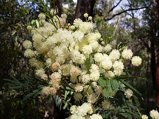
Acacia parramattensis, commonly known as Parramatta wattle, is a tree of the family Fabaceae native to the Blue Mountains and surrounding regions of New South Wales. It is a tall shrub or tree to about 15 m (49 ft) in height with phyllodes instead of true leaves. These are finely divided bipinnate. The yellow flowers appear over summer. It generally grows in woodland or dry sclerophyll forest on alluvial or shale-based soils, generally with some clay content.

<span class="mw-page-title-main">Woody Island (Western Australia)</span> Protected area in Western Australia

Woody Island is an island off the south coast in the Goldfields-Esperance region of Western Australia.

<span class="mw-page-title-main">Sydney Turpentine-Ironbark Forest</span> Critically endangered forest in Australia

The Sydney Turpentine-Ironbark Forest (STIF) is a wet sclerophyll forest community of Sydney, New South Wales, Australia, that is typically found in the Inner West and Northern region of Sydney. It is also among the three of these plant communities which have been classified as Endangered, under the New South Wales government's Threatened Species Conservation Act 1995, with only around 0.5% of its original pre-settlement range remaining.

<span class="mw-page-title-main">Apsley Falls</span> Two waterfalls on the Apsley River in New South Wales, Australia

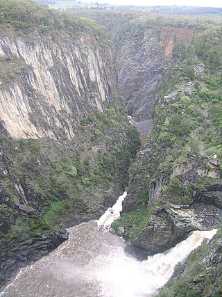
The Apsley Falls are two waterfalls on the Apsley River in the Northern Tablelands region of New South Wales, Australia. The falls are located about 20 kilometres (12 mi) east of Walcha, and 1 kilometre off the Oxley Highway in a deep gorge, that is part of the Oxley Wild Rivers National Park. They are the first falls in a succession of dramatic drops in an area that has some of the most remarkable scenery in Eastern Australia. The first drop of the falls is about 65 metres (213 ft) in depth, and the second, which is about 800 metres (2,625 ft) further on, plummets 58 metres (190 ft) to the bottom of the gorge.

<span class="mw-page-title-main">George Kendall Riverside Park</span> Recreational park in New South Wales

George Kendall Riverside Park is a 27.2-hectare (67-acre) recreational park in Ermington, New South Wales, on the northern bank of the Parramatta River.

<span class="mw-page-title-main">Flora of Australia</span> Plant species of Australia

The flora of Australia comprises a vast assemblage of plant species estimated to over 21,000 vascular and 14,000 non-vascular plants, 250,000 species of fungi and over 3,000 lichens. The flora has strong affinities with the flora of Gondwana, and below the family level has a highly endemic angiosperm flora whose diversity was shaped by the effects of continental drift and climate change since the Cretaceous. Prominent features of the Australian flora are adaptations to aridity and fire which include scleromorphy and serotiny. These adaptations are common in species from the large and well-known families Proteaceae (Banksia), Myrtaceae, and Fabaceae.

<span class="mw-page-title-main">Yarran Dheran</span>

Yarran Dheran Nature Reserve is a nature reserve that forms part of the Mullum Mullum Valley and is a bushland park, located in Melbourne on the border of Donvale, on the banks of the Mullum Mullum Creek. The reserve is 7.2 hectares and hosts a mix of remnant and regenerated bushland, and many native species of wildlife, particularly birds, of which 85 species may be seen. The Mullum Mullum Creek Trail runs through the reserve and there are many unsealed bush tracks through the native bushland. There is an information centre in the reserve that is open on Sunday afternoons from 2.00 pm – 4.00 pm, subject to volunteer availability. The reserve includes a series of ponds that feed a cascade to the creek during wet spells. There are toilets and mown areas for picnics and seating. Yarran Dheran is a Dogs on Lead reserve.

<i>Persoonia bargoensis</i> Species of flowering plant

Persoonia bargoensis, commonly known as the Bargo geebung, is a species of flowering plant in the family Proteaceae and is endemic to a restricted area of New South Wales. It is an erect shrub with linear to lance-shaped leaves, yellow, tube-shaped flowers and green, pear-shaped fruit.

The Burrinjuck Nature Reserve is a protected nature reserve on the south west slopes of New South Wales, Australia. The 5,250-hectare (13,000-acre) reserve is located adjacent to the Burrinjuck Dam, with 5,118 hectares of the reserve located on the northern side of the reservoir, and the remaining 89 hectares located on the southern side of the reservoir to the northeast of Black Andrew Nature Reserve. It includes land formerly managed as the Burrinjuck State Forest and Burrinjuck State Recreation Area.

The Black Andrew Nature Reserve is a protected nature reserve located on the south west slopes of New South Wales, Australia. The 1,559-hectare (3,850-acre) reserve is situated on the southern shore of Burrinjuck Dam on the Murrumbidgee River, an important reservoir for the Murrumbidgee Irrigation Area.

<span class="mw-page-title-main">Tasmanian dry sclerophyll forests</span>

Dry sclerophyll forests occur throughout northern and eastern Tasmania. Characterised by the population of hard-leafed (sclerophyll) and often spiky, drought-adapted plants, dry sclerophyll forests are found in regions of where annual rainfall is below 1000mm.

Ingalba, Big Bush and Pucawan Nature Reserves are three Nature Reserves situated to the west of Temora, New South Wales. Ingalba Nature Reserve is situated 10 kilometres west of Temora and Pucawan Nature Reserve a further 6 km west. Big Bush Nature Reserve is 15 kilometres northwest of Temora. All three reserves are located within Temora Shire. They are managed concurrently by the New South Wales Parks and Wildlife Service. The reserves are linked by corridors of vegetation in adjacent private land and along roads and Travelling Stock Routes.

<span class="mw-page-title-main">Joseph Banks Native Plants Reserve</span> Botanical garden in Sydney, NSW

Joseph Banks Native Plants Reserve is one of the few specialised gardens in Sydney to focus entirely on Australian native plants. Located at Kareela in Sutherland Shire and established in 1970 as a tribute to Joseph Banks, the landscaped garden covers an area of 2.2 hectares, with 4 kilometres of sealed paths.

<span class="mw-page-title-main">Cumberland Plain Woodland</span> Indigenous woodland community in Sydney, Australia

The Cumberland Plain Woodland, also known as Cumberland Plain Bushland and Western Sydney woodland, is a grassy woodland community found predominantly in Western Sydney, New South Wales, Australia, that comprises an open tree canopy, a groundcover with grasses and herbs, usually with layers of shrubs and/or small trees.

<span class="mw-page-title-main">Ecology of Sydney</span> Geographic aspect of Sydney, Australia

The ecology of Sydney, located in the state of New South Wales, Australia, is diverse for its size, where it would mainly feature biomes such as grassy woodlands or savannas and some sclerophyll forests, with some pockets of mallee shrublands, riparian forests, heathlands, and wetlands, in addition to small temperate rainforest fragments.

Folland Park is a fenced, 3.5-hectare reserve in the suburb of Enfield, South Australia. It is owned by the City of Port Adelaide Enfield, and consists of significant remnant vegetation that once covered much of the Adelaide Plains. The park is of special significance to botanists, and is under a heritage agreement to conserve its native vegetation and fauna.

References

  1. Heapy, Steven. "Shire Maps". Shire Maps. Sutherland Shire Council. Archived from the original on 29 February 2016. Retrieved 1 March 2016.
  2. Heapy, Steven. "Bushcare Locations". Sutherland Shire Council. Sutherland Shire Council. Retrieved 1 March 2016.
  3. 1 2 3 4 "Report: Caravan Head Bushland 2001". Sutherland Shire Council. Sutherland Shire Council. September 2001.
  4. 1 2 3 4 "Report: Caravan Head Bushland 2004". Sutherland Shire Council. Sutherland Shire Council. December 2004.
  5. 1 2 3 4 "Report: Caravan Head Reserve Bush Regeneration Works July - August 2011". Sutherland Shire Council. Sutherland Shire Council. September 2011.
  6. 1 2 3 4 "Report: Caravan Head Reserve Bush Regeneration Works November - January 2013". Sutherland Shire Council. Sutherland Shire Council. February 2013.

33°59′56″S151°04′55″E / 33.9988°S 151.0819°E / -33.9988; 151.0819