
Beverly Hills is a southern suburb of Sydney, in the state of New South Wales, Australia. Beverly Hills is located 15 kilometres southwest of the Sydney central business district and is part of the St George area and is split between the local government areas of the Georges River Council and the City of Canterbury-Bankstown. The postcode is 2209, which it shares with neighbouring Narwee.

Sutherland is a suburb in southern Sydney, in the state of New South Wales, Australia. Sutherland is located 26 kilometres south of the Sydney central business district and is the administrative centre for the local government area of the Sutherland Shire.

The A6 is a route designation of a major metropolitan arterial route through suburban Sydney, linking Cumberland Highway at Carlingford and Princes Highway at Heathcote, via Lidcombe and Bankstown. This name covers a few consecutive roads and is widely known to most drivers, but the entire allocation is also known – and signposted – by the names of its constituent parts: Marsden Road, Stewart Street, Kissing Point Road, Silverwater Road, St Hilliers Road, Boorea Street, Olympic Drive, Joseph Street, Rookwood Road, Stacey Street, Fairford Road, Davies Road, Alfords Point Road, New Illawarra Road and Heathcote Road.

Sutherland Shire is a local government area (LGA) in the southern region of Sydney, in the state of New South Wales, Australia. Sutherland Shire is located approximately 26 kilometres south-southwest of the Sydney central business district, and comprises an area of 370 square kilometres (140 sq mi). As at the 2016 census, Sutherland Shire has an estimated population of 218,464. The area is colloquially known as "The Shire", and has featured in several reality television series.
Southern Sydney is the southern metropolitan area of Greater Sydney, in the state of New South Wales, Australia.

Menai is a suburb in southern Sydney, in the state of New South Wales, Australia 29 kilometres south of the Sydney central business district in the local government area of the Sutherland Shire.

Padstow, a suburb of local government area City of Canterbury-Bankstown, is located 21 kilometres south-west of the Sydney central business district, in the state of New South Wales, Australia, and is a part of the South-western Sydney region. Padstow is a mostly residential suburb bounded on the north by Bankstown and on the east by Salt Pan Creek, which is a stream feeding into the Georges River. The M5 South Western Motorway traverses the northern end of the suburb, which is also the location of a number of light industrial facilities.

The Division of Hughes is an Australian electoral division in the state of New South Wales.
Alfords Point is a suburb in southern Sydney, in the state of New South Wales, Australia. Alfords Point is 28 kilometres south of the Sydney central business district, within the local government area of the Sutherland Shire. Alfords Point shares the postcode of 2234 with neighbouring suburbs of Menai, Bangor and Illawong.

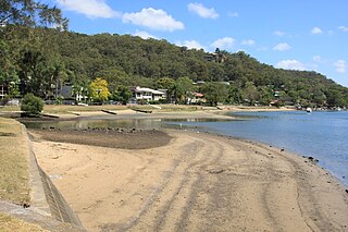
Illawong is a suburb in southern Sydney, in the state of New South Wales, Australia. Illawong is located 27 kilometres south of the Sydney Central Business District, in the local government area of the Sutherland Shire in the area commonly called Menai. The post code is 2234, which is also assigned to the contiguous suburbs of Menai, Bangor Barden Ridge and Alfords Point.

Barden Ridge is a suburb in southern Sydney, in the state of New South Wales, Australia. Barden Ridge is located 29 kilometres south of the Sydney central business district in the local government area of the Sutherland Shire. Barden Ridge is colloquially known to locals as 'The Ridge'.
Woronora is a suburb in southern Sydney, in the state of New South Wales, Australia. Woronora is located 27 kilometres south of the Sydney central business district, in the local government area of the Sutherland Shire. Woronora Heights is a separate suburb, to the south-west.

Woronora Heights is a suburb in southern Sydney, in the state of New South Wales, Australia. Woronora Heights is located 29 kilometres south of the Sydney central business district, in the local government area of the Sutherland Shire. Woronora is a separate suburb, to the north. Most streets in Woronora Heights are named after birds.
Sandy Point is a suburb in south-western Sydney, in the state of New South Wales, Australia 28 km south-west of the Sydney central business district, in the local government area of the Sutherland Shire.

Padstow Heights, a suburb of local government area of the City of Canterbury-Bankstown, located 22 kilometres south-west of the Sydney central business district, in the state of New South Wales, Australia. It is a part of the South-western Sydney region. Padstow is a separate suburb to the north and One Tree Point is a locality within Padstow Heights.

Bonnet Bay is a suburb in southern Sydney, in the state of New South Wales, Australia that is located 29 kilometres (18 mi) south of the Sydney central business district in the local government area of the Sutherland Shire. Its postcode is 2226, which it shares with neighbouring Jannali and Como.

Sutherland railway station is a heritage-listed railway station located on the Illawarra line, serving the Sydney suburb of Sutherland. It is served by Sydney Trains' T4 Eastern Suburbs & Illawarra Line services and NSW TrainLink's South Coast Line services.
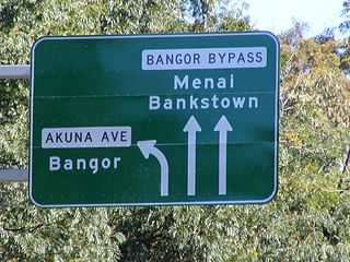
Bangor Bypass is a road in New South Wales, Australia, between New Illawarra Road and River Road, bypassing Bangor and Menai. Completed in February 2005, it replaced Menai Road as the main road between A6 and River Road, alleviating traffic on Menai Road and increasing travel speed through Bangor and Menai. It also acts as a western extension of River Road and Woronora Bridge, which was completed four years earlier in 2001. A section of New Illawarra Road north of the bypass was also completed as part of the project, linking the bypass directly to Alfords Point Road.

The Menai Roosters Rugby League Football Club is a rugby league football club that was formed in 1981 and competes in the Cronulla-Sutherland District Rugby Football League. The club is based out of Akuna Oval at Bangor where its clubhouse and headquarters are located and usually draws the large majority of its junior players from Menai and the surrounding suburbs of Bangor, Illawong, Alfords Point and Barden Ridge.

Metrobus is a high frequency, high capacity bus network in Sydney, Australia, first introduced in 2008. Metrobus services run every 10 minutes during peak periods, 15 minutes during off-peak weekday periods, and 20 minutes on weekends, linking key commercial suburbs and centres throughout the city, with the intention of making timetables obsolete. All buses were initially painted in a distinctive red livery but recently, the standard Transport for NSW livery of blue and white has been adopted. All Metrobus services are wheelchair accessible. All route numbers were prefixed with an "M" followed by a two-digit number.


