Yowie Bay | |||||||||||||
|---|---|---|---|---|---|---|---|---|---|---|---|---|---|
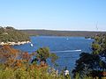
 Yowie Bay marina | |||||||||||||
 Yowie Bay Location in greater metropolitan Sydney | |||||||||||||
 | |||||||||||||
| Coordinates: 34°02′59″S151°06′12″E / 34.04972°S 151.10333°E | |||||||||||||
| Country | Australia | ||||||||||||
| State | New South Wales | ||||||||||||
| City | Sydney | ||||||||||||
| LGA | |||||||||||||
| Location |
| ||||||||||||
| Established | 1889 | ||||||||||||
| Government | |||||||||||||
| • State electorates | |||||||||||||
| • Federal division | |||||||||||||
| Elevation | 28 m (92 ft) | ||||||||||||
| Population | |||||||||||||
| • Total | 3,053 (SAL 2021) [1] | ||||||||||||
| Postcode | 2228 | ||||||||||||
| |||||||||||||
Yowie Bay is a suburb in southern Sydney, in the state of New South Wales, Australia. Yowie Bay is located 24 kilometres south of the Sydney central business district, in the local government area of the Sutherland Shire.
Contents
Yowie Bay takes its name from the small bay on the north shore of the Port Hacking estuary (also known locally as the Port Hacking River). It is bounded to the north by the suburb of Miranda and shares its postcode of 2228. Located to the east, across the Yowie Bay waterway, is Caringbah South. To the west is the suburb of Gymea Bay, across the bay of the same name.