Cronulla, New South Wales

Last updated

Cronulla
Sydney,  New South Wales
2019-09-22 Cronulla, New South Wales.jpg
Cronulla, New South Wales, pictured facing south in September 2019.
Cronulla, New South Wales
Population17,899 (2021 census) [1]
Established1908
Postcode(s) 2230
Elevation20 m (66 ft)
Location26 km (16 mi) south of Sydney CBD
LGA(s) Sutherland Shire
State electorate(s) Cronulla
Federal division(s) Cook
Suburbs around Cronulla:
Caringbah Kurnell Greenhills Beach
Woolooware Cronulla Bate Bay
Burraneer Maianbar Bundeena
South end of North Cronulla Beach North Cronulla Beach 1.JPG
South end of North Cronulla Beach

Cronulla is a suburb of Sydney, in the state of New South Wales, Australia. Boasting numerous surf beaches and swimming spots, the suburb attracts both tourists and Greater Sydney residents. Cronulla is 26 kilometres south of the Sydney central business district, in the local government area of the Sutherland Shire.

Contents

Cronulla is on a peninsula framed by Botany Bay to the north, Bate Bay to the east, Port Hacking to the south, and Gunnamatta Bay to the west. The neighbouring suburb of Woolooware lies to the west of Cronulla, and Burraneer lies to the southwest. The Kurnell peninsula, the site of the first landfall on the eastern coastline made by Captain James Cook in 1770, is reached by driving northeast out of Cronulla on Captain Cook Drive.

History

Cronulla is derived from the Aboriginal word Kurranulla, meaning "place of the small pink seashell" in the dialect of the area's Indigenous inhabitants, the Gweagal, who were a clan of the Tharawal (or Dharawal) tribe. They inhabited the southern geographic areas of Sydney. The beaches were named by Surveyor Robert Dixon who surveyed here in 1827-28 and, by 1840, the main beach was still known as Karranulla. [2] In July 1852 the schooner Venus was wrecked on the beach, which was referred to in newspaper reports as Cooranulla. [3]

Matthew Flinders and George Bass explored and mapped the coastline and Port Hacking estuary in 1796 and the southernmost point of Cronulla is named Bass and Flinders Point in their honour. John Connell received a grant of 380 acres (1.5 km2) in 1835. Thomas Holt (1811–88) owned most of the land that stretched from Sutherland to Cronulla in the 1860s. Holt built Sutherland House on the foreshore of Gwawley Bay in 1818, on the eastern side of Sylvania. In 1888 master mariner Captain Joseph Henry Rounce Spingall became the pioneering resident of Cronulla when, with his family, he constructed the two-storey 'Oriental Guest House' on land above where today's North Cronulla Hotel sits. The Depression of 1890 and a lack of reliable transport access from Sutherland saw "The Captain's" pub sold. The Cronulla area was subdivided in 1895 and land was offered for sale at 10 pounds per acre. In 1899, the government named the area Gunnamatta, which means sandy hills. On 26 February 1908, it was officially changed to Cronulla and Gunnamatta was used for the name of the bay, on the western side.

Northies Hotel Northies cronulla..jpg
Northies Hotel

After the Illawarra railway line was built to Sutherland in 1885, the area became popular for picnics and swimming. Steam trams operated between Cronulla and Sutherland from 1911. Many regulars rented beach houses at Cronulla every year for school holidays. The Oriental Hotel was built by Captain Spingall in 1888, on the present site of apartments behind the North Cronulla Hotel. The Cecil Hotel was located on the foreshore of South Cronulla and the Ritz Café was popular with holiday-makers. The Cecil Apartments were built on the former site of this hotel. The steam trams were replaced by the Cronulla branch of the Illawarra railway line when it opened in 1939. [4]

The post office opened in January 1891, known as Cronulla Beach, but closed in 1893. It reopened in 1907 and the name was officially changed to Cronulla in 1929. The Cronulla School of Arts was established in 1904. The original wooden building was demolished and replaced by the current School of Arts building in November 1912 and is now one of the oldest buildings in Cronulla.

The first public school opened in 1910.[ citation needed ] In 1955, Cronulla Library opened. [5] From the 1950s, many of the guest houses began being replaced by high rise flats. Even though it developed as a residential area, Cronulla remained popular with beachgoers and tourists. Several hotels, motels and serviced apartments operate today. The Cronulla Bicentennial Plaza opened in February 1989.

In 2005 the beachfront at Cronulla was the scene of widely publicised mob disturbances and violent confrontations. [6] These incidents continued over a number of days and also spread to other areas in Sydney. [7]

Heritage listings

Cronulla has a number of heritage-listed sites, including:

Beaches

Greenhills Beach Sand Dunes Sand Dunes in the Sutherland Shire, Sydney 3.jpg
Greenhills Beach Sand Dunes

Cronulla is a popular tourist attraction and attracts many beachgoers from all over Sydney. Cronulla Beach features a long stretch of sand that runs from Boat Harbour to North Cronulla, followed by rock pools and another sandy beach at South Cronulla. The beaches of Cronulla from north to south are: Boat Harbour, Greenhills Beach, Wanda Beach, Elouera Beach, North Cronulla Beach, Cronulla Beach, Blackwoods Beach, Shelly Beach and Oak Park Beach. Local names also apply to various parts of the beach, such as The Alley, between Cronulla Beach and North Cronulla, The Wall, between North Cronulla and Elouera, Midway, between Elouera and Wanda,Sandshoes, near the mouth of the Port Hacking estuary, Voodoo Reef and The Point. The beaches are popular recreational areas for swimming, surfing, bodyboarding, bodysurfing and other water sports. [12]

Shark Island, just off Cronulla Beach, is a famous surfing and bodyboarding spot, and the site of the annual Shark Island Challenge bodyboarding contest. Gunnamatta Bay provides protected swimming at the baths off Gunnamatta Park. Port Hacking is a popular location for such water sports as waterskiing and wakeboarding.

Parks

Dunningham Park, North Cronulla North Cronulla Dunningham Park 2.JPG
Dunningham Park, North Cronulla
Oak Park, South Cronulla Cronulla - panoramio (60).jpg
Oak Park, South Cronulla

Commercial area

Cronulla Theatre and Cronulla Plaza Cronulla1.jpg
Cronulla Theatre and Cronulla Plaza

The main shopping strip runs along Cronulla Street, which has been partly converted into a pedestrian mall known as Cronulla Plaza. It also extends along the Kingsway, Gerrale Street and other surrounding streets. Cronulla has developed a café culture, with some cafés and restaurants located along the North Cronulla foreshore and Cronulla Plaza. The suburb boasts a Rydges high-rise hotel, although tourists can choose from a variety of hotels, motels and serviced apartments. Cronulla has many restaurants, nightclubs, pubs and bars, as well as a brand-new Hoyts cinema that opened late-2020. [14]

Transport

Cronulla Ferry Wharf Cronulla Ferry Wharf 2.JPG
Cronulla Ferry Wharf

Trains terminate at Cronulla railway station on the Cronulla branch of the Illawarra railway line, on the Sydney Trains network. Cronulla Tunnel Gallery is just north of the station, linking Cronulla Street to Tonkin Street.

Cronulla & National Park Ferry Cruises runs passenger services around Port Hacking and a regular route between Cronulla and Bundeena, on the edge of the Royal National Park. The Cronulla Ferry wharf sits on Gunnamatta Bay, beside Tonkin Park.

U-Go Mobility operates several bus routes that stop at Cronulla Railway Station. For full details of all bus services see Cronulla station.

Sport and recreation

Cronulla Beach and rock pool Cnulla beach.jpg
Cronulla Beach and rock pool

Events

Demographics

According to the 2021 census, there were 17,899 people in Cronulla.

Notable residents

Schools

Cronulla is home to a number of primary and secondary schools:

Churches

There are several churches in the Cronulla area:

See also

Related Research Articles

<span class="mw-page-title-main">Miranda, New South Wales</span> Suburb of Sydney, New South Wales, Australia

Miranda is a suburb in southern Sydney, in the state of New South Wales, Australia. The suburb is known as a commercial centre for the southern suburbs. Miranda is 24 kilometres south of the Sydney central business district, in the Sutherland Shire.

<span class="mw-page-title-main">Bundeena, New South Wales</span> Suburb of Sydney, New South Wales, Australia

Bundeena is a village and suburb on the outskirts of southern Sydney, in the state of New South Wales, Australia. Bundeena is located 29 kilometres south of the Sydney central business district and is part of the local government area of the Sutherland Shire.

<span class="mw-page-title-main">Caringbah</span> Suburb of Sydney, New South Wales, Australia

Caringbah is a suburb in Southern Sydney, in the state of New South Wales, Australia. Caringbah is 24 kilometres (15 mi) south of the Sydney central business district in the local government area of Sutherland Shire.

<span class="mw-page-title-main">Gymea, New South Wales</span> Suburb of Sydney, New South Wales, Australia

Gymea is a suburb in southern Sydney, in the state of New South Wales, Australia. Gymea is located 26 kilometres south of the Sydney central business district in the local government area of the Sutherland Shire. The postcode is 2227, which it shares with adjacent suburb Gymea Bay.

<span class="mw-page-title-main">Sutherland, New South Wales</span> Suburb of Sydney, New South Wales, Australia

Sutherland is a suburb in southern Sydney, in the state of New South Wales, Australia. Sutherland is located 26 kilometres south of the Sydney central business district and is the administrative centre for the local government area of the Sutherland Shire.

<span class="mw-page-title-main">Sutherland Shire</span> Local government area in New South Wales, Australia

Sutherland Shire is a local government area in the southern region of Sydney, in the state of New South Wales, Australia. The Sutherland Shire is located just south of the Sydney CBD, and comprises an area of 370 square kilometres (140 sq mi) and as at the 2016 census and has an estimated population of 218,464. The Sutherland Shire is colloquially known as "The Shire" which has been featured in several reality television series.

<span class="mw-page-title-main">Woolooware</span> Suburb of Sydney, New South Wales, Australia

Woolooware is a suburb in southern Sydney, in the state of New South Wales, Australia. Woolooware is located 24 kilometres (15 mi) south of the Sydney central business district in the Sutherland Shire. It shares the 2230 postcode with Cronulla.

<span class="mw-page-title-main">Port Hacking</span> Estuary in southern Sydney, Australia

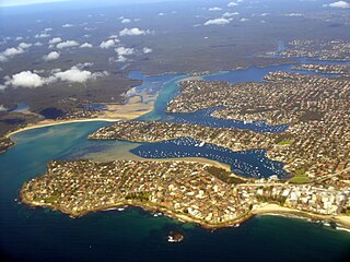
Port Hacking Estuary, an open youthful tide dominated, drowned valley estuary, is located in southern Sydney, New South Wales, Australia approximately 30 kilometres (19 mi) south of Sydney central business district. Port Hacking has its source in the upper reaches of the Hacking River south of Helensburgh, and several smaller creeks, including South West Arm, Bundeena Creek and The Basin and flows generally to the east before reaching its mouth, the Tasman Sea, south of Cronulla and north–east of Bundeena. Its tidal effect is terminated at the weir at Audley, in the Royal National Park. The lower estuary features a substantial marine delta, which over time has prograded upstream. There is also a substantial fluvial of the Hacking River at Grays Point. The two deltas are separated by a deep basin.

<span class="mw-page-title-main">Maroubra, New South Wales</span> Suburb of Sydney, New South Wales, Australia

Maroubra is a beachside suburb in the Eastern Suburbs of Sydney, in the state of New South Wales, Australia. It is 10 kilometres south-east of the Sydney central business district in the local government area of the City of Randwick.

<span class="mw-page-title-main">Burraneer, New South Wales</span> Suburb of Sydney, New South Wales, Australia

Burraneer is a bayside suburb in southern Sydney, in the state of New South Wales, Australia. Burraneer is 26 kilometres south of the Sydney central business district, in the local government area of the Sutherland Shire.

<span class="mw-page-title-main">Gymea Bay, New South Wales</span> Suburb of Sydney, New South Wales, Australia

The locality and suburb of Gymea Bay are located in southern Sydney, in the state of New South Wales, Australia. Gymea Bay is 27 kilometres (17 mi) south of the Sydney central business district, in the local government area of the Sutherland Shire. The postcode is 2227, which it shares with the adjacent suburb of Gymea. The Gymea Bay locality takes its name from the adjoining Gymea Bay, a small bay on the north side of the Port Hacking estuary).

<span class="mw-page-title-main">Gunnamatta Bay</span>

The Gunnamatta Bay is a small bay in southern Sydney, New South Wales, Australia.

<span class="mw-page-title-main">Cronulla Beach</span>

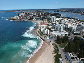
Cronulla Beach, is a patrolled beach on Bate Bay in the Sydney suburb of Cronulla, New South Wales, Australia. The Cronulla Pavilion and the Cronulla Lifesaving Club are two prominent buildings located close to the sand. Cronulla Park sits behind the beach. The Cronulla Rock Pools are between Cronulla Beach and North Cronulla beach. The Alley is the local name given to the area between Cronulla Beach and North Cronulla Beach. Shark Island is a dangerous reef break, located off Cronulla Beach.

<span class="mw-page-title-main">Wanda Beach</span>

Wanda Beach or Wanda is the northernmost patrolled beach at Bate Bay in Cronulla, Sydney, New South Wales, New South Wales, Australia. Green Hills or Green Hills Ridge is the name given to the Cronulla sand dunes, just north of Wanda.

<span class="mw-page-title-main">Elouera Beach</span>

Elouera Beach or Elouera is a patrolled beach on Bate Bay, in Cronulla, Sydney, New South Wales, Australia. The Wall is the local name given to the area between North Cronulla Beach and Elouera.

<span class="mw-page-title-main">North Cronulla Beach</span> Beach in New South Wales, Australia

North Cronulla Beach or North Cronulla is a patrolled beach on Bate Bay, in Cronulla, Sydney New South Wales, Australia. The Wall is the local name given to the area between North Cronulla Beach and Elouera. The Alley is the local name given to the permanent rip current located at the southern end of North Cronulla Beach.

<span class="mw-page-title-main">Cronulla sand dunes</span> Sand dunes in Sydney, New South Wales, Australia

The Cronulla sand dunes, also known officially as the Cronulla Sand Dune and Wanda Beach Coastal Landscape, are an open space, heritage-listed nature conservation, and visitor attraction located on the Kurnell Peninsula at Lindum Road, Kurnell within the Sutherland Shire local government area of Sydney, New South Wales, Australia. Formerly, it was a site for sand mining, film making, and had use as pastoral property. It is also known as part of Kurnell Peninsula Headland and Cronulla Sand Hill. It was added to the New South Wales State Heritage Register on 26 September 2003.

The Burraneer Bay is a bay on the lower estuarine Hacking River of Port Hacking in southern Sydney, in the state of New South Wales, Australia.

<span class="mw-page-title-main">Greenhills Beach</span>

Greenhills Beach is an unpatrolled beach on Bate Bay, located in Greenhills Beach, Sydney, New South Wales, Australia. The beach is located roughly 18 kilometres from the Sydney central business district, in the local government area of the Sutherland Shire. Recognised as one of Sydney's longest beaches, Greenhills beach is roughly 3 kilometres in length and forms part of a chain of beaches residing on Bate Bay. It is the northernmost section of the Greenhills-North Cronulla beach complex and is the only section of the beach not to be patrolled by a Surf Club or by volunteer lifesavers.

References

  1. 1 2 Australian Bureau of Statistics (28 June 2022). "Cronulla (State Suburb)". 2021 Census QuickStats. Retrieved 27 November 2023. OOjs UI icon edit-ltr-progressive.svg
  2. http://www.sutherland.nsw.gov.au/ssc/rwpattach.nsf/0/Factsheet_6_FINAL_20030728.pdf/$file/Factsheet_6_FINAL_20030728.pdf Sutherland Shire Place Names Archived 4 October 2006 at the Wayback Machine
  3. Sydney Morning Herald, 30 Jun 1852,p2
  4. The Book of Sydney Suburbs, Compiled by Frances Pollon, Angus & Robertson Publishers, 1990, Published in Australia ISBN   0-207-14495-8
  5. Watt, Bruce (2014). The Shire : A journey through time. China: Everbest. p. 199. ISBN   9780646920191.
  6. "Mob violence envelops Cronulla". Australian Associated Press. 11 December 2005. Retrieved 31 August 2006.
  7. "Now churches are targeted". The Australian. Archived from the original on 8 February 2006. Retrieved 31 August 2006.
  8. "Cronulla Sand Dune and Wanda Beach Coastal Landscape". New South Wales State Heritage Register . Department of Planning & Environment. H01668. Retrieved 18 May 2018. CC BY icon.svg Text is licensed by State of New South Wales (Department of Planning and Environment) under CC-BY 4.0 licence .
  9. "Cronulla Railway Station group". New South Wales State Heritage Register . Department of Planning & Environment. H01123. Retrieved 18 May 2018. CC BY icon.svg Text is licensed by State of New South Wales (Department of Planning and Environment) under CC-BY 4.0 licence .
  10. "Cronulla Post Office (Place ID 106203)". Australian Heritage Database . Australian Government . Retrieved 23 September 2018.
  11. "Cronulla Fisheries Centre, The". New South Wales State Heritage Register . Department of Planning & Environment. H01011. Retrieved 18 May 2018. CC BY icon.svg Text is licensed by State of New South Wales (Department of Planning and Environment) under CC-BY 4.0 licence .
  12. "Cronulla". Sydney.com. Retrieved 12 June 2013.
  13. Trembath, Murray (13 April 2018). "Flashback Friday | When Monro Park nearly became a car park". St George & Sutherland Shire Leader . Retrieved 14 April 2018.
  14. Trembath, Murray (22 November 2019). "Saved! | Hoyts to take over Cronulla cinema". St George & Sutherland Shire Leader. Retrieved 13 February 2020.
  15. National Championships awarded to Cronulla Grand Prix Cycling NSW. Retrieved 13 December 2009
  16. Daniel Lane McEwen leads pack of cycling aces in race to rebuild shire's reputation Sydney Morning Herald, 26 November 2006. Retrieved 13 December 2009
  17. John Veage "Big Win for Bate Bay Body Bashers". www.theleader.com.au. 12 September 2017. Retrieved 18 January 2018.
  18. "My Site". www.wsaainc.com. Retrieved 13 January 2018.
  19. "Events & What's Happening". Thursday 26 January 2012. Cronulla Beach YHA Sydney NSW Australia. Archived from the original on 14 March 2013. Retrieved 12 June 2013.

34°03′27″S151°09′08″E / 34.05744°S 151.15219°E / -34.05744; 151.15219