
The Gold Coast, also known by its initials, GC, is a coastal city and region in the state of Queensland, Australia, located approximately 66 kilometres (41 mi) south-southeast of the centre of the state capital, Brisbane. It is Queensland’s second-largest city after Brisbane, as well as Australia’s sixth-largest city and the most populous non-capital city, with a population over 600,000. The city’s central business district is located roughly in the centre of the Gold Coast in the suburb of Southport. The urban area of the Gold Coast is concentrated along the coast, sprawling almost 60 kilometres, joining up with the Greater Brisbane metropolitan region to the north and to the state border with New South Wales to the south. Nicknames of the city include the ‘Glitter Strip’ and the ‘Goldy’. The demonym of a Gold Coast resident is Gold Coaster.

The Tweed River is a river situated in the Northern Rivers region of New South Wales, Australia. From the middle reaches of its course, the state boundary between New South Wales and Queensland is located approximately 10 kilometres (6.2 mi) north.

Tweed Heads is a coastal city at the mouth of the Tweed River in the Northern Rivers region of the state of New South Wales, Australia. Tweed Heads is the northernmost town in New South Wales, and is located in the Tweed Shire local government area. It is situated 830 km (520 mi) north of Sydney and 103 km (64 mi) south of Brisbane. The town is next to the border with Queensland and is adjacent to its "twin town" of Coolangatta, which is a suburb of the Gold Coast in Queensland.

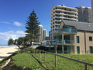
Coolangatta is a coastal suburb in the City of Gold Coast, Queensland, Australia. It is the Gold Coast's southernmost suburb and it borders New South Wales. In the 2021 census, Coolangatta had a population of 6,491 people.

Burleigh Heads is a suburb in the City of Gold Coast, Queensland, Australia. In the 2021 census, Burleigh Heads had a population of 10,572 people.
Main Beach is a coastal town and suburb in the City of Gold Coast, Queensland, Australia. In the 2021 census, the suburb of Main Beach had a population of 3,998 people.

Palm Beach is a coastal suburb in the City of Gold Coast, Queensland, Australia. In the 2021 census, Palm Beach had a population of 16,349 people.
Miami is a coastal suburb in the City of Gold Coast, Queensland, Australia. In the 2021 census, Miami had a population of 7,445 people.

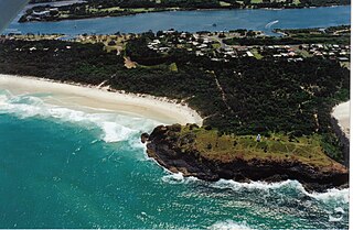
Snapper Rocks is a small rocky outcrop on the northern side of Point Danger at the southern end of Rainbow Bay on the Gold Coast, Queensland, Australia. It is a famous surf break and today the start of the large sand bank known to surfers as the Superbank.

Greenmount Beach is a beach located in Coolangatta on Queensland's Gold Coast in Australia.
Fingal Head is a village on the Tasman Sea coast in the far northeast of New South Wales, Australia, about 5 km south of the New South Wales and Queensland border. The village is often just called Fingal. The headland and the small off-shore Island were first sighted by James Cook about 17:00 on 16 May 1770. At the time of the 2021 census, Fingal Head had a population of 592 people.

The history of the Gold Coast in Queensland, Australia began in prehistoric times with archaeological evidence revealing occupation of the district by indigenous Australians for at least 23,000 years. The first early European colonizers began arriving in the late 1700s, settlement soon followed throughout the 19th century, and by 1959 the town was proclaimed a city. Today, the Gold Coast is one of the fastest-growing cities in Australia.

Bilinga is a southern coastal suburb in the City of Gold Coast, Queensland, Australia. It is on the border with New South Wales. In the 2021 census, Bilinga had a population of 1,883 people.

Tugun is a beach-side coastal suburb in the City of Gold Coast, Queensland, Australia. In the 2021 census, Tugun had a population of 7,175 people.

Mermaid Beach is a coastal suburb of the City of Gold Coast in Queensland, Australia. In the 2021 census, Mermaid Beach had a population of 7,329 people.
The Gold Coast Shoreline Management Plan (GCSMP) is an ICZM plan to manage the coastal resources of City of Gold Coast. The EPA encourages the City Council's to produce shoreline management plans for coastlines and tidal waterways within the local authority area.
Narrow Neck is the name of an isthmus that separates the anabranch of the Nerang River from the Coral Sea in the City of Gold Coast, Queensland, Australia. It is also the boundary between the southern end of the suburb of Main Beach and the northern end of the suburb of Surfers Paradise.

A surf break is a permanent obstruction such as a coral reef, rock, shoal, or headland that causes a wave to break, forming a barreling wave or other wave that can be surfed, before it eventually collapses. The topography of the seabed determines the shape of the wave and type of break. Since shoals can change size and location, affecting the break, it takes commitment and skill to find good breaks. Some surf breaks are quite dangerous, since the surfer can collide with a reef or rocks below the water.
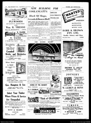
Jazzland Dance Hall, also known as Jazzland Dance Palais, was a dance hall located in Coolangatta, Queensland. The venue was built in 1928 and was used as an entertainment venue throughout the first half of the twentieth century. Though no longer used for dances and social events, the building remains at the western end of McLean Street at the intersection with Griffith Street. The former dance hall is listed on the Gold Coast Local Heritage Register as a rare surviving purpose built ballroom built in Queensland, Australia during the interwar period and in acknowledgement of its role of the social life of the region. It is also recognised in the Coolangatta Local Area Plan for its heritage and character components. In 2002 the building was considered for the Queensland State Heritage Register but was not listed.
Campbell Hill is a mountain located in Piggabeen, New South Wales (NSW), Australia. It is located in the region of the Tweed Shire in the state of New South Wales, in the eastern part of the country, 900 kilometres (560 mi) north of the capital, Canberra, approximately 107 kilometres (66 mi) from Brisbane and 24 kilometres (15 mi) from Surfers Paradise. Campbell Hill is approximately 123 metres (404 ft) above sea level. Piggabeen is situated in the hinterland approximately 5 km behind the Gold Coast Highway and the Gold Coast International and Domestic Airport. Piggabeen and its valley adjoins Currumbin Valley in Queensland.


