Related Research Articles

The Gold Coast, often referred to by its initials G.C., and officially the City of Gold Coast, is Australia’s sixth-largest city, the most populous non-capital city in the Australian state of Queensland, and the state's second-largest city after Brisbane, with a population over 600,000. The Gold Coast is a coastal city and region located approximately 66 kilometres (41 mi) south-southeast of the centre of the state capital, Brisbane. The city's central business district is located roughly in the centre of the Gold Coast in the suburb of Southport. The urban area of the Gold Coast is concentrated along the coast, sprawling almost 60 kilometres, joining up with the Greater Brisbane metropolitan region to the north and to the state border with New South Wales to the south. Nicknames of the city include the ‘Glitter Strip’ and the ‘Goldy’. The demonym of a Gold Coast resident is Gold Coaster.

Tweed Heads is a coastal town at the mouth of the Tweed River in the Northern Rivers region of the state of New South Wales, Australia. Tweed Heads is the northern most town in New South Wales, and is located in the Tweed Shire local government area. It is situated 830 km (520 mi) north of Sydney and 103 km (64 mi) south of Brisbane. The town is next to the border with Queensland and is adjacent to its "twin town" of Coolangatta, which is a suburb of the Gold Coast in Queensland.

Coolangatta is a coastal suburb in the City of Gold Coast, Queensland, Australia. It is the Gold Coast's southernmost suburb and it borders New South Wales. In the 2016 census, Coolangatta had a population of 5,948 people.

The City of Gold Coast is the local government area spanning the Gold Coast, Queensland, Australia and surrounding areas. With a population of 606,774, it is the second most populous local government area in the State of Queensland. Its council maintains a staff of over 2,500. It was established in 1948, but has existed in its present form since 2008. It is on the border with New South Wales with the Tweed Shire to the south in New South Wales.

Kirra is a beach-side neighbourhood within the suburb of Coolangatta in the City of Gold Coast, Queensland, Australia.

Ian Keith was an American actor.

The South Coast railway line was a railway from Brisbane, the capital city of Queensland, Australia. The route via the South Coast to Tweed Heads on the border of Queensland and New South Wales. The line operated from 1889 to 1964. The Gold Coast railway line re-opened in 1996 along a modified alignment in the north and a new route south but does not extend as far south yet as the South Coast line.

Balldale is a village in the mid-southern part of the Riverina in New South Wales, Australia. It is about 15 kilometres (9.3 mi) north-east of Corowa and about 18 kilometres (11 mi) west of Brocklesby.
King's Highway 39, commonly referred to as Highway 39, was a provincially maintained highway in the Canadian province of Ontario. The 33.8-kilometre (21.0 mi)-long route connected Highway 3 in downtown Windsor with Highway 2 south of Belle River, travelling along the southern shoreline of Lake St. Clair. Highway 39 was established in 1934. By 1961, the Pike Creek Bypass was opened and Highway 39 was rerouted along it, with the former route briefly becoming Highway 39B. The route was renumbered as Highway 2 in 1970, retiring the designation from the provincial highway system. Highway 2 was itself decommissioned along the former route of Highway 39 on January 1, 1998, and transferred to Essex County and the City of Windsor. It was subsequently redesignated as Essex County Road 22.
The Shire of Tingalpa was a local government area in the south-eastern suburbs of Brisbane, Queensland, Australia. The shire, administered from Mount Cotton, covered an area of 120 square miles (311 km2), and existed as a local government entity from 1879 until 1949.
The Shire of Beenleigh is a former local government area in the south-east of Queensland, Australia, centred on the town of Beenleigh. It existed from 1879 to 1949.

The Shire of Cleveland is a former local government area in the south-east of Queensland, Australia, centred on the town of Cleveland beside Moreton Bay.
The Shire of Waterford is a former local government area in the south-east of Queensland, Australia, centred on the town of Waterford. It existed between 1879 and 1948.

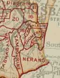
The Shire of Coomera was a local government area in South East Queensland, Australia. The shire, administered from Coomera, existed as a local government entity from 1879 until 1949.

The Shire of Nerang was a local government area in South East Queensland, Australia. The shire existed as a local government entity from 1879 until 1949.
The Shire of Tamborine was a local government area in South East Queensland, Australia, centred on the village of Tamborine. It existed from 1890 to 1949.

The Town of Southport was a local government area in South East Queensland, Australia.
The Town of Coolangatta was a local government area in South East Queensland, Australia, centred on Coolangatta. It existed from 1914 to 1949.
The Coolangatta Chronicle was a weekly newspaper printed and published between 1924 and 1927 by Crampton and Co. in Maclean Street Coolangatta, Queensland, Australia, on the border of Tweed Heads, New South Wales. It was one of the early, but short lived, publications written for the residents of the region that would later be known as the Gold Coast, Queensland.
Jazzland Dance Hall, also known as Jazzland Dance Palais, was a dance hall located in Coolangatta, Queensland. The venue was built in 1928 and was used as an entertainment venue throughout the first half of the twentieth century. Though no longer used for dances and social events, the building remains at the western end of McLean Street at the intersection with Griffith Street. The former dance hall is listed on the Gold Coast Local Heritage Register as a rare surviving purpose built ballroom built in Queensland, Australia during the interwar period and in acknowledgement of its role of the social life of the region. It is also recognised in the Coolangatta Local Area Plan for its heritage and character components. In 2002 the building was considered for the Queensland State Heritage Register but was not listed.
References
- ↑ The Border Star, Tweed Heads and Coolangatta Newspapers Ltd, 1927, retrieved 30 June 2020
- ↑ "WE SAY—FAREWELL". Border Star (Coolangatta, Qld. : 1929 - 1942). 30 January 1942. p. 2. Retrieved 30 June 2020.
| Authority control databases: National |
|---|