
Lavender Bay is a harbourside suburb on the lower North Shore of Sydney, New South Wales, Australia. Lavender Bay is located three kilometres north of the Sydney central business district, in the local government area of North Sydney Council.

Akuna Bay is an urban place in Sydney, Australia. Akuna Bay is located 38 kilometres (24 mi) north of the Sydney central business district, in the local government area of Northern Beaches Council.

Farm Cove is a tidal inlet and shallow bay in Sydney Harbour, separated from Sydney Cove by Bennelong Point, New South Wales, Australia. Farm Cove is one of the places around Sydney Harbour that has been officially gazetted as a dual named site by the Geographical Names Board (GNB). The official dual name for this place is: 'Farm Cove / Wahganmuggalee'.

The Division of Mackellar is an Australian electoral division in the state of New South Wales.
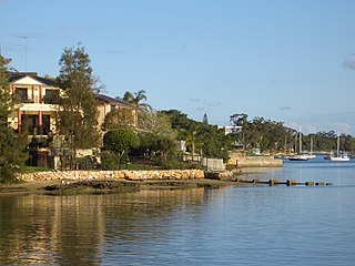
Tennyson Point is a suburb of Sydney, New South Wales, Australia. Tennyson Point is located 10 kilometres west of the Sydney central business district, in the local government area of the City of Ryde and is part of the Northern Sydney region.
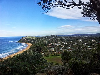
Bilgola Plateau is a suburb in Sydney's Northern Beaches in the state of New South Wales, Australia.

Elizabeth Bay is a harbourside inner city suburb in the Eastern suburbs of Sydney, in the state of New South Wales, Australia. Elizabeth Bay is located three kilometres east of the Sydney central business district and is part of the local government area of the City of Sydney.

White Bay is a bay on Sydney Harbour with a surrounding locality near the suburbs of Balmain and Rozelle in the Inner West of Sydney, New South Wales, Australia.

Box Head is a coastal locality in the Central Coast Council local government area located on the Central Coast of New South Wales, Australia. It is within Bouddi National Park which includes the island of Lion Island.
Phegans Bay is a suburb within the local government area of the Central Coast Council on the Central Coast of New South Wales, Australia.

The Mooney Mooney Creek, a perennial river that is part of the Hawkesbury-Nepean catchment, is located in the Central Coast region of New South Wales, Australia.

Petersham Parish is one of the 57 parishes of Cumberland County, New South Wales, a cadastral unit for use on land titles. It is located to the south of Iron Cove, Rozelle Bay and the Parramatta River, and to the north of Cooks River. It includes the suburbs of Balmain, Leichhardt, Petersham, Newtown, Marrickville, Tempe, Glebe and St Peters. It roughly corresponds to the eastern half of the Inner West region, with the neighbouring Parish of Concord making up the western half.

Concord Parish is one of the 57 parishes of Cumberland County, New South Wales, a cadastral unit for use on land titles. It is located to the south of the Parramatta River between Homebush Bay and Iron Cove; and to the north of Cooks River. It includes the suburbs of Homebush, most of Strathfield, Burwood, Croydon, Concord, Canada Bay, Abbotsford and Drummoyne. It covers the local government areas of City of Canada Bay and the Municipality of Burwood and most of the Municipality of Strathfield. It roughly corresponds to the western half of the Inner West region, with the neighbouring Parish of Petersham making up the eastern half.
Morning Bay is a road-inaccessible suburb and adjoining bay in northern Sydney, in the state of New South Wales, Australia. Morning Bay is located 40 kilometres north of the Sydney central business district, in the local government area of Northern Beaches Council.

Elvina Bay is a bay and an adjacent suburb in northern Sydney, in the state of New South Wales, Australia. It is located 35 kilometres north of the Sydney central business district, in the local government area of Northern Beaches Council.

Lovett Bay is a suburb and adjacent bay in northern Sydney, in the state of New South Wales, Australia. It is 36 kilometres north of the Sydney central business district, in the local government area of Northern Beaches Council.
Kingfisher Shores is a suburb of the Central Coast region of New South Wales, Australia. It is part of the Central Coast Council local government area.

The Wyong River is a perennial river that is located in the Central Coast region of New South Wales, Australia.

The Mogo Creek, a perennial stream of the Hawkesbury-Nepean catchment, is located in the Blue Mountains region of New South Wales, Australia.
Boggywell Creek, an urban gully that is part of the Georges River catchment, is located in the southern Sydney district of St George, in New South Wales, Australia.
