
Brett Whiteley AO was an Australian artist. He is represented in the collections of all the large Australian galleries, and was twice winner of the Archibald, Wynne and Sulman prizes. He held many exhibitions, and lived and painted in Australia as well as Italy, England, Fiji and the United States.
Greenwich is a suburb on the Lower North Shore of Sydney, New South Wales, Australia. Greenwich is located 7 kilometres (4 mi) north-west of the Sydney central business district, in the local government area of the Municipality of Lane Cove.

The North Shore Line is a railway line serving the North Shore in Sydney, New South Wales, Australia. The North Shore Line extends from Sydney Central station through the western limb of the City Circle, across the Sydney Harbour Bridge and through the North Shore area to Hornsby where it joins the Main North Line. Services on the line are primarily provided by the T1 North Shore & Western Line and T9 Northern Line, with some services to Wyong during peak hours.

Kirribilli is a suburb of Sydney, New South Wales, Australia. One of the city's most established and affluent neighbourhoods, it is located three kilometres north of the Sydney central business district, in the local government area administered by North Sydney Council. Kirribilli is a harbourside suburb, sitting on the Lower North Shore of Sydney Harbour. Kirribilli House is one of the two official residences of the Prime Minister of Australia.

North Sydney is a suburb and major commercial district on the Lower North Shore of Sydney, New South Wales, Australia. It is located three kilometres north of the Sydney central business district and is the administrative centre for the local government area of North Sydney Council.

Milsons Point railway station is a heritage-listed railway station located on the North Shore line, serving the Sydney suburb of Milsons Point in New South Wales, Australia. It is served by Sydney Trains T1 North Shore line services. The station is located above ground, accessible via stairs and a lift, in Milsons Point, in the North Sydney Council local government area of New South Wales, Australia. It was designed and built by the Sydney Harbour Bridge Branch of the NSW Department of Public Works. The property was added to the New South Wales State Heritage Register on 2 April 1999.

Waverton railway station is a heritage-listed railway station located on the North Shore line, serving the Sydney suburb of Waverton in New South Wales, Australia. It is served by Sydney Trains T1 North Shore line services. The station is located on Bay Road, Waverton, in the North Sydney Council local government area of New South Wales, Australia. It was designed and built by New South Wales Department of Railways. It is also known as Waverton Railway Station group. The station was added to the New South Wales State Heritage Register on 2 April 1999.

The first Lavender Bay railway station was opened on 30 May 1915 at a site 300 metres north of the original Milsons Point station on the North Shore line on the edge of Lavender Bay. The station was created by building platforms beside the existing lines. An overbridge was constructed leading to a new ferry wharf. Southbound trains used to drop their passengers at Lavender Bay station and then proceed to Milsons Point railway station to reverse.

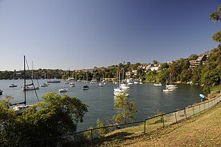
Longueville is an affluent harbourside suburb on the Lower North Shore of Sydney, New South Wales, 8 kilometres north of the Sydney central business district, in the local government area of the Municipality of Lane Cove.

Milsons Point is a suburb on the lower North Shore of Sydney, in the state of New South Wales, Australia. The suburb is located 3 kilometres north of the Sydney central business district in the local government area of North Sydney Council.

Cremorne Point is a harbourside suburb on the Lower North Shore of Sydney, New South Wales, Australia located six kilometres north of the Sydney central business district, in the local government area of North Sydney Council.

McMahons Point is a harbourside suburb on the lower North Shore of Sydney, New South Wales, Australia. McMahons Point is located 3 kilometres north of the Sydney central business district, in the local government area of North Sydney Council. McMahons Point sits on the peninsula flanked by Berrys Bay to the west and Lavender Bay to the east. The lower tip of the peninsula is known as Blues Point, which offers expansive views of Port Jackson. The postcode is 2060.

Waverton is a harbour-side suburb on the lower North Shore of Sydney, New South Wales, Australia. Waverton is 4 kilometres north of the Sydney central business district, in the local government area of North Sydney Council.

Linley Point is a small peninsular suburb located on the Lower North Shore of Sydney, in the local government area of the Municipality of Lane Cove, in the state of New South Wales, Australia. It is approximately 10 kilometres north-west of the Sydney central business district by car.
Birchgrove is a suburb in the Inner West of Sydney, in the state of New South Wales, Australia. Birchgrove is located five kilometres west of the Sydney central business district, in the local government area of the Inner West Council.

Dawes Point is a suburb of the City of Sydney, in the state of New South Wales, Australia. Dawes Point is located on the north-western edge of the Sydney central business district, at the southern end of Sydney Harbour Bridge, adjacent to The Rocks. Historically, Dawes Point has been considered to be part of the suburb of Millers Point and the name change is controversial.

Kurraba Point is a harbourside suburb on the lower North Shore of Sydney, New South Wales, Australia. Kurraba Point is located 4 kilometres north of the Sydney central business district, in the local government area of North Sydney Council.
Wendy Susan Whiteley is best known as the former wife of the Australian artist Brett Whiteley, and as the mother of their daughter, actress Arkie Whiteley (1964–2001). She has become a notable cultural figure, particularly since her ex-husband's death in 1992. She posed for Brett many times. Although they divorced three years before he died, she has control of Brett Whiteley's estate including the copyright to his works. She played an important role in the establishment of the Brett Whiteley Studio in Surry Hills, New South Wales which is now owned and managed as an art museum by the Art Gallery of New South Wales.

Jeffrey Street or Jeffreys Street is a street located in Kirribilli, famous for being one of the most popular vantage points for views of the city skyline of Sydney, the Sydney Harbour Bridge and the Sydney Opera House. The street is located on the Lower North Shore of Sydney Harbour, directly across the harbour from Circular Quay and is a popular destination for tourists, particularly on Australia Day and New Year's Eve. The street leads uphill from the harbour in a northerly direction to the small shopping village of Kirribilli. For many years the area was called the North Shore and the original land grant changed hands a number of times. Over the past 200 years the area has also been called Huntershill, St Leonards, North Sydney, "Kiarabilli", Milsons Point and "Kirribilli Point". The modern spelling Kirribilli was first used in 1853 and the use of Kirribilli as a locality is more recent.

Brett Whiteley House is a heritage-listed arts and crafts studio and residence in Lavender Bay, New South Wales, Australia. It was built during 1905 by Henry Green. It is also known as Brett Whiteley House and Visual Curtilage and Lochgyle. It was added to the New South Wales State Heritage Register on 23 March 2018.


