
Rhodes is an Inner West suburb of Sydney, in the state of New South Wales, Australia. Rhodes is located 12 kilometres west of the Sydney central business district, in the local government area of the City of Canada Bay. It was formerly part of Concord Municipality until a merger with Drummoyne Council to form Canada Bay in December 2000. People from Rhodes are colloquially known as Rhoders or Rhodesiens.
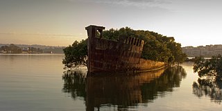
Homebush Bay is a bay on the south bank of the Parramatta River, in the west of Sydney, Australia. The name is also sometimes used to refer to an area to the west and south of the bay itself, which was formerly an official suburb of Sydney, and has now become the suburbs of Sydney Olympic Park, Wentworth Point and part of the neighbouring suburb of Lidcombe, all part of the City of Parramatta. Homebush Bay is located 13 kilometres (8.1 mi) west of the Sydney central business district.

Homebush is a suburb in the Inner West of Sydney in the state of New South Wales, Australia. It is located 12 kilometres west of the Sydney central business district, in the local government area of the Municipality of Strathfield.

The Municipality of Strathfield is a local government area in the Inner West of Sydney, in the state of New South Wales, Australia.

The Inner West of Sydney is an area directly west of the Sydney central business district, New South Wales, Australia. The suburbs that make up the Inner West are predominantly located along the southern shore of Port Jackson, stretching south to the shores of the Cooks River. The western boundary of the Inner West is approximately the A3 arterial road, which divides the Inner West from the Greater Western Sydney region. The Inner West is much larger than the Inner West Council local government area. The Inner West roughly corresponds with the Parish of Petersham and Parish of Concord, two cadastral divisions used for land titles.
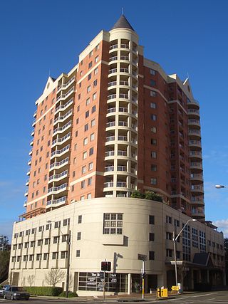
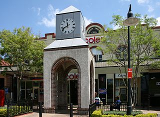
Strathfield is a suburb in the Inner West of Sydney, in the state of New South Wales, Australia. It is located 12 kilometres west of the Sydney central business district and is the administrative centre of the Municipality of Strathfield. A small section of the suburb north of the railway line lies within the City of Canada Bay, while the area east of The Boulevard lies within the Municipality of Burwood. North Strathfield and Strathfield South are separate suburbs to the north and south, respectively.
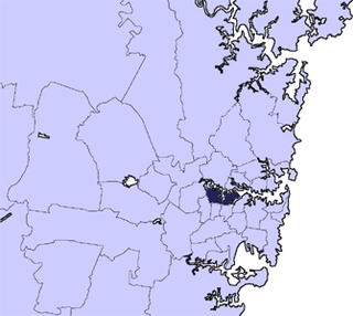
The City of Canada Bay is a local government area just outside the Inner West of Sydney, New South Wales, Australia. The city was formed on 1 December 2000, following the merger of Concord and Drummoyne councils. The city covers an area of 19.82 square kilometres (7.65 sq mi) and as at the 2021 census had a resident population of 89,177. The city is ultimately named after Canada Bay, a bay and suburb along the Parramatta River.

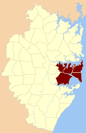
The Division of Lowe was an Australian Electoral Division in the state of New South Wales. It was located in the inner western suburbs of Sydney, on the south shore of the Parramatta River. It included the suburbs of Drummoyne, Five Dock, Croydon, Croydon Park, Burwood, Enfield, Homebush, Strathfield, Concord, Rhodes, Canada Bay, Cabarita, Abbotsford and Mortlake.

The Division of Reid is an Australian electoral division in the state of New South Wales.

North Strathfield is a suburb in the inner-west of Sydney, in the state of New South Wales, Australia. North Strathfield is located 15 kilometres west of the Sydney central business district, in the local government area of the City of Canada Bay. Strathfield and Strathfield South are separate suburbs, to the south.
Concord is a suburb in the inner West of Sydney, in the state of New South Wales, Australia. It is 10 kilometres (6.2 mi) west of the Sydney central business district, in the local government area of the City of Canada Bay. Concord West is a separate suburb, to the north-west.

Concord West is a suburb on the periphery of Sydney's inner-west, in the state of New South Wales, Australia. Concord West is located 16 km west of the Sydney central business district, in the local government area of the City of Canada Bay. Concord is a separate suburb, to the east.

Flemington, officially gazetted as "Homebush West" since 1992, is a suburb in the Inner West of Sydney, in the state of New South Wales, Australia. Flemington is located 13 kilometres west of the Sydney central business district, in the local government area of the Municipality of Strathfield, with a small unpopulated area in Cumberland Council.

St George Parish is one of the 57 parishes of Cumberland County, New South Wales, a cadastral unit for use on land titles. It is bounded in the north by the Cooks River, in the west by Cox's Creek and Salt Pan Creek, and in the south by the Georges River and in the east by Botany Bay.

Hunters Hill Parish is one of the 57 parishes of Cumberland County, New South Wales, a cadastral unit for use on land titles. It includes the eponymous suburb of Hunters Hill and the Municipality of Hunter's Hill in the east, while the western part of the parish largely corresponds with the City of Ryde.

Petersham Parish is one of the 57 parishes of Cumberland County, New South Wales, a cadastral unit for use on land titles. It is located to the south of Iron Cove, Rozelle Bay and the Parramatta River, and to the north of Cooks River. It includes the suburbs of Balmain, Leichhardt, Petersham, Newtown, Marrickville, Tempe, Glebe and St Peters. It roughly corresponds to the eastern half of the Inner West region, with the neighbouring Parish of Concord making up the western half.

Liberty Plains Parish is one of the 57 parishes of Cumberland County, New South Wales, a cadastral unit for use on land titles. It is bounded by Parramatta Road in the north; the boundary between Flemington and Homebush, a small part of Cooks River and Liverpool Road in the east; the Hume Highway also in the south; and Woodville Road in the west. It includes the suburbs of Homebush West (Flemington), part of Strathfield, Auburn, Regents Park, Potts Hill, Sefton, Chester Hill, Bass Hill and Lidcombe. It also includes the Rookwood Cemetery. Before the parish was proclaimed in 1835, the Liberty Plains district was in the same area. The name had been given when the first settlers had desired a settlement midway between Parramatta and Sydney city. The name is still used on a motor inn in the area. In the 1851 census there were 49 houses and 270 people in the Liberty Plains parish.
The Hundred of Sydney is a former lands administrative division for the city of Sydney and its inner suburbs. It was one of the thirteen hundreds in the County of Cumberland, which were published in the government gazette of May 27, 1835, and repealed on January 21, 1888.

The metropolis of Greater Sydney in New South Wales, Australia, is informally subdivided into a number of geographic regions. The geographical definition of Greater Sydney spans across 33 local government areas and includes the Blue Mountains in the west, the Northern Beaches and the Hawkesbury in the north, the Royal National Park, the Wollondilly and Macarthur in the south, and Botany Bay in the east. These areas sometimes, but not always, roughly coincide with official boundaries of suburbs, local government authorities, or cadastral units, and some of the customary regions do not have well defined boundaries at all. Some commonly referred to regions overlap: for example, Canterbury-Bankstown is often referred to as a region, but it is also part of the South Western Sydney region. The regions themselves are not used as a formal jurisdiction, and generally do not have administrative or legislative bodies, although some regions are coterminous with a local government area, and in a number of regions that include multiple local government areas, Regional Organisations of Councils have been established that represent the councils in the region.

Wentworth Point is a suburb of Sydney, in the state of New South Wales, Australia. It is located 13 kilometres west of the Sydney central business district, on the eastern edge of the local government area of City of Parramatta. It is on the western shore of Homebush Bay on the southern side of the Parramatta River. Wentworth Point is usually regarded as part of the Greater Western Sydney region, including in administrative contexts, but it is also regarded as part of the Inner West region of Sydney in some contexts, especially commercial contexts.

