Central Coast Council, New South Wales

Last updated

Central Coast Council
New South Wales
Central Coast LGA NSW.png
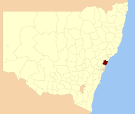
Location of Central Coast LGA in NSW
Population
 • Density194.96/km2 (504.96/sq mi)
Established12 May 2016 (2016-05-12)
Area1,681 km2 (649.0 sq mi) [3]
Time zone AEST (UTC+10)
 • Summer (DST) AEDT (UTC+11)
MayorJane Smith
Council seat Gosford
Region Central Coast
State electorate(s)
Federal Division(s)
Central Coast Council logo.png
Website Central Coast Council
LGAs around Central Coast Council:
Cessnock Lake Macquarie Tasman Sea
Hawkesbury Central Coast Council Tasman Sea
Hornsby Northern Beaches Tasman Sea

The Central Coast Council is a local government area serving the Central Coast region of New South Wales, Australia, established on 12 May 2016 following the amalgamation of Gosford City and Wyong Shire councils. [3]

Local government in Australia is the third tier of government in Australia administered by the states and territories, which in turn are beneath the federal tier. Local government is not mentioned in the Constitution of Australia and two referenda in the 1970s and 1980s to alter the Constitution relating to local government were unsuccessful. Every state government recognises local government in their respective constitutions. Unlike Canada or the United States, there is only one level of local government in each state, with no distinction such as cities and counties.

Central Coast (New South Wales) City in New South Wales, Australia

The City of Central Coast, a peri-urban region in the Australian state of New South Wales (NSW), lies on the Tasman Sea coast north of Sydney and south of Lake Macquarie.

New South Wales State of Australia

New South Wales is a state on the east coast of Australia. It borders Queensland to the north, Victoria to the south, and South Australia to the west. Its coast borders the Tasman Sea to the east. The Australian Capital Territory is an enclave within the state. New South Wales' state capital is Sydney, which is also Australia's most populous city. In September 2018, the population of New South Wales was over 8 million, making it Australia's most populous state. Just under two-thirds of the state's population, 5.1 million, live in the Greater Sydney area. Inhabitants of New South Wales are referred to as New South Welshmen.

Contents

The council comprises an area of 1,681 square kilometres (649 sq mi) and is bounded to the east by the Tasman Sea, to the south by Broken Bay and the Hawkesbury River, and to the west by the Yengo National Park northwards to Bucketty before heading eastward along George Downes Drive, encompassing the Olney State Forest and crossing the Pacific Motorway, meeting the southern edge of Lake Macquarie at Mannering Park and eventually reaching the coast north of Moonee. As at the 2016 census the council area had an estimated population of 327,736. [1]

Tasman Sea A marginal sea of the South Pacific between Australia and New Zealand

The Tasman Sea is a marginal sea of the South Pacific Ocean, situated between Australia and New Zealand. It measures about 2,000 kilometres (1,200 mi) across and about 2,800 kilometres (1,700 mi) from north to south. The sea was named after the Dutch explorer Abel Janszoon Tasman, who was the first recorded European to encounter New Zealand and Tasmania. The British explorer Captain James Cook later extensively navigated the Tasman Sea in the 1770s as part of his first voyage of exploration.

Broken Bay bay

Broken Bay, a semi–mature tide-dominated drowned valley estuary, is a large inlet of the Tasman Sea located about 50 kilometres (31 mi) north of Sydney central business district on the coast of New South Wales, Australia; being one of the bodies of water that separate greater Metropolitan Sydney from the Central Coast. Broken Bay is the first major bay north of Sydney Harbour.

Hawkesbury River river in New South Wales, Australia

The Hawkesbury River, is a semi–mature tide dominated drowned valley estuary located to the west and north of Sydney, New South Wales, Australia. The Hawkesbury River and its associated main tributary, the Nepean River, virtually encircle the metropolitan region of Sydney.

The inaugural Mayor of the Central Coast Council is Jane Smith (Independent), who was elected on 26 September 2017. [4]

Suburbs and localities

The local government area includes a moderately densely populated coastal strip that extends northward from the Hawkesbury River and is bounded by the Pacific Motorway to the west, and an extensive sparsely-populated region to the west of the motorway that is largely native bush. The towns and villages located within Central Coast Council are:

Alison, New South Wales Suburb of Central Coast, New South Wales, Australia

Alison is a semi-rural suburb of the Central Coast region of New South Wales, Australia, located on the north bank of the Wyong River 4 kilometres (2.5 mi) northwest of the regional centre of Wyong. It is part of the Central Coast Council local government area.

Avoca Beach, New South Wales Suburb of Central Coast, New South Wales, Australia

Avoca Beach is a coastal suburb of the Central Coast region of New South Wales, Australia, about 95 kilometres (59 mi) north of Sydney. Avoca Beach is primarily a residential suburb but also a popular tourist destination. Avoca Beach village has a variety of restaurants and cafes as well as a post office, newsagent, pharmacy and mini-mart. Avoca Beach also has a historic cinema, a hotel, bowling club, motel and caravan park. It is located within the Central Coast Council local government area.

Bar Point is a suburb of the Central Coast region of New South Wales, Australia, located on the north bank of the Hawkesbury River 53 kilometres (33 mi) north of Sydney. It is part of the Central Coast Council local government area.

Demographics

At the 2016 Census the population of the Central Coast local government area was 327,736. [5]

Selected historical census data for Central Coast local government area
Census year2016 [1]
PopulationEstimated residents on census night 327,736
LGA rank in terms of size within New South Wales 3rd
% of New South Wales population
% of Australian population
Cultural and language diversity
Ancestry,
top responses
English 31.3%
Australian 30.2%
Irish 9.3%
Scottish 7.5%
German 2.5%
Language,
top responses
(other than English)
Spanish 0.5%
Mandarin 0.5%
Italian 0.4%
German 0.3%
Cantonese 0.3%
Religious affiliation
Religious affiliation,
top responses
No religion 27.6%
Catholic 24.7%
Anglican 22.5%
Not Stated8.2%
Uniting Church 3.2%
Median weekly incomes
Personal income Median weekly personal incomeA$600
% of Australian median income
Family incomeMedian weekly family incomeA$1560
% of Australian median income
Household incomeMedian weekly household incomeA$1258
% of Australian median income

Council

From amalgamation on 12 May 2016 to September 2017, the Central Coast Council area was administered by Ian Reynolds, with former Wyong Shire Acting General Manager Rob Noble appointed as Interim General Manager and Gosford City General Manager Paul Anderson appointed Deputy General Manager. [6]

Georges River Council comprises fifteen Councillors elected proportionally, with three Councillors elected in five wards. [7] Councillors are elected for a fixed four-year term of office, with the first term to last for three years. [8] The Mayor is elected by Councillors for a period of two years, the Deputy Mayor is elected for one year.

MayorTermNotes
Administrator Ian Reynolds12 May 2016 – 26 September 2017General Manager of Blacktown City Council 2000–2005 [7]
MayorJane Smith26 September 2017 – date [4]
Deputy Mayor Chris Holstein 26 September 2017 – dateMayor of Gosford 2002–2010 [4]
General Manager/CEOTermNotes
Rob Noble12 May 2016 – 20 September 2017Acting General Manager of Wyong Shire 2015–2016 [7]
Brian Bell20 September 2017 – dateGeneral Manager of Lake Macquarie 2006–2017 [9]

Current composition

The most recent election was held on 9 September 2017, and the makeup of the Council by order of election, is as follows:

PartyCouncillors
  Australian Labor Party 6
  Independents 5
  Liberal Party of Australia 4
Total15
WardCouncillorPartyNotes
Budgewoi Ward [10]  Doug VincentLaborWyong A Ward Councillor 2008–2016
 Jillian HoganLabor
 Greg BestIndependentMayor of Wyong 2002–2004
Gosford East Ward [11]  Rebecca Gale CollinsLiberal
 Jeff SundstromLabor
 Jane SmithIndependentMayor 2017–date
Gosford West Ward [12]  Richard MehrtensLabor
 Troy MarquartLiberal
  Chris Holstein IndependentDeputy Mayor 2017–date
The Entrance Ward [13]  Lisa MatthewsLaborWyong B Ward Councillor 2008–2016
 Jilly PilonLiberal
 Bruce McLachlanIndependent
Wyong Ward [14]  Kyle MacGregorLabor
 Louise GreenawayIndependent
 Chris BurkeLiberalGosford City Councillor 2008–2016

See also

Related Research Articles

City of Gosford Local government area in New South Wales, Australia

The City of Gosford is a former local government area located on the Central Coast region, in the state of New South Wales, Australia. On 12 May 2016 the Minister for Local Government amalgamated the City of Gosford and Wyong Shire Councils. The Central Coast Council was established on the same day, covering the combined areas.

Wyong Shire Local government area in New South Wales, Australia

Wyong Shire was a local government area located in the Central Coast region of New South Wales, Australia, north of Sydney.

Central Coast & Newcastle Line rail service in New South Wales, Australia

The Central Coast & Newcastle Line is a NSW TrainLink passenger train service that runs along the Main North railway line in New South Wales, connecting the state's two largest cities, Sydney and Newcastle. The service runs from Central through to Broadmeadow on the Main North railway line to Newcastle Interchange on the Newcastle railway line, and services the Hawkesbury River region, the Central Coast and the city of Newcastle.

Woy Woy railway station

Woy Woy railway station is located on the Main Northern line in New South Wales, Australia. It serves the southern Central Coast suburb of Woy Woy opening on 1 February 1889.

Umina Beach, New South Wales Suburb of Central Coast, New South Wales, Australia

Umina Beach is a suburb within the Central Coast Council local government area on the Central Coast of New South Wales, Australia. By road, it is 85 kilometres (53 mi) north of the Sydney CBD and 111 kilometres (69 mi) south of the Newcastle CBD.

Gosford railway station railway station on Main Northern line in New South Wales, Australia

Gosford railway station is located on the Main Northern line in New South Wales, Australia. It serves the Central Coast city of Gosford, opening on 15 August 1887.

Patonga is a suburb of the Central Coast region of New South Wales, Australia, located on the north bank of the Hawkesbury River, southwest of Woy Woy. It is part of the Central Coast Council local government area.

Central Coast Division Rugby League

The Central Coast Division of Country Rugby League is a rugby league competition based on the Central Coast of New South Wales between Sydney and Newcastle. It was founded in 1947 as a junior competition for the Newcastle club, Lakes United. In 1967, it was upgraded again to full membership of the Country Rugby League as Group 12. In 1981, it was renamed Central Coast Division. The division covers the entire region of the Central Coast from Woy Woy and Umina in the south up to Budgewoi and Gwandalan in the north.

David Robert Harris is an Australian politician. He has been a Labor Party member of the New South Wales Legislative Assembly since 2015, representing the electorate of Wyong. He previously represented the same electorate from 2007 to 2011.

Country Cricket New South Wales, is responsible for the development of cricket in regional New South Wales. It is under control of the governing body Cricket NSW.

Coast Shelter is a non-profit organisation assisting homeless young people and adults in the Central Coast region of New South Wales, Australia. The service was founded in 1992 as Gosford Emergency Accommodation Services. The service's predecessor was the Rumbalara Youth Refuge established by Gosford City Council in 1985. Since the its founding, the organisation has assisted over 16,000 individuals.

This article provides information on the Reserve Grade, Second Grade or B Grade Grand Finals of Rugby League competitions held on the Central Coast of New South Wales, Australia. The Match Details sub-section details the individual point-scorers in a match, where known.

This article provides information on the First Grade or A Grade premiership deciders of Rugby League competitions held on the Central Coast of New South Wales, Australia. The Match Details sub-section details the individual point-scorers in a match, where known. That section shall be expanded upon in the near future.

This article provides information on the under 16 premiership deciders of rugby league competitions held on the Central Coast of New South Wales, Australia. The Match Details sub-section details the individual point-scorers in a match, where known. In 1996 and all but one season since 2003, a second tier under 16 competition has also been held.

This article provides information on the under 16 premiership deciders of rugbyleague competitions held on the Central Coast of New South Wales, Australia. The Match Details sub-section details the individual point-scorers in a match, where known.

This article provides information on the under 18 premiership deciders of rugby league competitions held on the Central Coast of New South Wales, Australia. The Match Details sub-section details the individual point-scorers in a match, where known.

This article provides information on the under 19 premiership deciders of rugby league competitions held on the Central Coast of New South Wales, Australia. The Match Details sub-section details the individual point-scorers in a match, where known.

References

  1. 1 2 3 Australian Bureau of Statistics (27 June 2017). "Central Coast (C)". 2016 Census QuickStats. Retrieved 6 July 2017. Blue pencil.svg
  2. "3218.0 – Regional Population Growth, Australia, 2017-18". Australian Bureau of Statistics. 27 March 2019. Retrieved 27 March 2019. Estimated resident population (ERP) at 30 June 2018.
  3. 1 2 "Central Coast Council". Stronger Councils. Government of New South Wales. 12 May 2016. Retrieved 14 May 2016.
  4. 1 2 3 Killman, Fiona (26 September 2017). "CENTRAL COAST COUNCIL ELECTS INDEPENDENT COUNCILLOR JANE SMITH AS INAUGURAL MAYOR". Central Coast Gosford Express Advocate. Retrieved 29 September 2017.
  5. "2016 Census QuickStats: Central Coast (C) (NSW)". quickstats.censusdata.abs.gov.au. Retrieved 29 November 2018.
  6. "Central Coast Council Officially Underway". City of Gosford. 12 May 2016. Retrieved 14 May 2016.
  7. 1 2 3 "Local Government (Council Amalgamations) Proclamation 2016 [NSW] - Schedule 3 - Provisions for Central Coast Council" (PDF). Parliament of New South Wales. 12 May 2016. p. 15. Retrieved 8 October 2016.
  8. "Central Coast Council". Stronger Councils. Government of New South Wales. 12 May 2016. Retrieved 15 May 2016.
  9. Killman, Fiona (20 September 2017). "CENTRAL COAST COUNCIL CEO ROB NOBLE STEPS DOWN TODAY". Central Coast Gosford Express Advocate. Retrieved 29 September 2017.
  10. "Central Coast - Budgewoi Ward". NSW Local Council Elections 2017. NSW Electoral Commission. Retrieved 29 September 2017.
  11. "Central Coast - Gosford East Ward". NSW Local Council Elections 2017. NSW Electoral Commission. Retrieved 29 September 2017.
  12. "Central Coast - Gosford West Ward". NSW Local Council Elections 2017. NSW Electoral Commission. Retrieved 29 September 2017.
  13. "Central Coast - The Entrance Ward". NSW Local Council Elections 2017. NSW Electoral Commission. Retrieved 29 September 2017.
  14. "Central Coast - Wyong Ward". NSW Local Council Elections 2017. NSW Electoral Commission. Retrieved 29 September 2017.