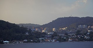
At the 2016 census East Gosford had a population of 4,238 people.[5]
History
A photograph of Peeks Point in 1921. Caroline Bay and Point Frederick are in the background.
The site where East Gosford now stands changed hands twice before being sold to Samuel Peek, a Sydney tea merchant. East Gosford was surveyed in 1841 and within a year, began to develop, when Peek began to sell land there. A wharf and several shops were built.[6] After building a three-story hotel, Peek and his family went to England in 1850. Returning in 1857, their ship wrecked near the Gap, and all family members perished.[7] Many of his private papers were lost in the wreck, and he left no heirs, so many of his buildings decayed with bricks, doors and woodwork disappearing.[8]
In 1858 a small sandstone church was built and was centrally located for parishioners from Erina, Gosford and Terrigal. However, when the railway was opened, more people began to live closer to Gosford. The church became unused and so it was decided to move the church, stone-by-stone to Mann Street, Gosford where it is still located.[6]
Located on the eastern border of East Gosford is Erina Creek. Originally the creek provided access to the many ketches and steamers which came in and out on timber business. A man operating a punt carried people and their goods across Erina Creek. In 1884 the Government called tenders for the construction of an irondrawbridge with timber approaches. On 15 September, the tender of John Johnstone was accepted and work began. The bridge was completed in 1886, probably early in the year, at a cost of £3,695/15/-, which was considerably more than the average cost of £500 for country bridges. Part of the bridge rolled back towards the Gosford side by means of wheels guided on rails. This was achieved by men cranking the mechanism by hand. The bridge was opened seven times a day. The last of the steamers to go through was the Lone Pine in 1928.[9] The old Punt Bridge, as it was called, was replaced by a modern bridge built by Beattie and Frost Pty Ltd of Gosford in 1962.[10] It is still known as The Punt Bridge and forms part of the Central Coast Highway.
In 1913 two sisters, the Misses Marion and Aileen Macabe, opened a school for girls at Boomera, later known as Hinemoa Private Hospital in Masons Parade, Gosford. Some years later the expanded school was moved into Mona Vale built by William Rogers. Completed in 1889, this residence now forms part of St Edward's College. The property on which Mona Vale was built was part of an original 20 acres (8ha)crown grant to surveyor William Shone in 1844. Subsequent owners were Charles Venteman, James Harrison and William Tyrrell, Bishop of Newcastle. It was Tyrrell's death in 1879 which led to the subdivision and public auction of the property. A portion was bought by William Rogers for £490. He demolished an earlier house on the land when he built Mona Vale.[11] The school took boarders and day students (the latter included a few small boys), and offered a very wide range of subjects. Extras such as Esperanto, elocution, dancing and music could be undertaken and popular sports were swimming, rowing and tennis. Gosford livery stable owner Sam Ranyard assisted Aileen Maccabe in giving horse-riding instructions and also supplied horses. In 1923 the MacCabe sisters were faced with overcrowding problems and moved their school to Lindfield, where it was known as Marshall Mount.[12]
Negotiations began in 1951 between the Christian Brothers and Mr W. Rogers for the purchase of Mona Vale and adjacent land. St Edward's College construction started in 1952 and Mona Vale was restored. In the 1970s the old house again underwent restoration and was used as a staffroom and administration centre for the college until 2005.[12]
There are currently four schools in East Gosford. St Patrick's, a Catholic school and Gosford East Public School both cater for boys and girls from kindergarten to year six.[13][14] St. Edward's Christian Brothers College, a Catholic boys' school, and St. Joseph's Catholic College, a girls' school, both cater for students from years seven to twelve.[15][16]
Gosford Regional Gallery and Gosford/Edogawa Commemorative Garden are located in East Gosford. The Commemorative Garden is a Japanese garden that was built as a gift to residents of Gosford City Council by the Ward of Edogawa, Tokyo, Japan. They were opened in September 1994.[17]
In the past East Gosford had branches for all four major banks, however these had been progressively closed by 2000. As a result, the Chamber of Commerce sought to open a Bendigo Bank Community branch. The branch was opened on 5 August 2000.[18] The branch has been credited with a turnaround in retail trading in East Gosford. The East Gosford Community Bank has now expanded and operates a second branch at Lisarow and an agency at Kincumber.[19]
In 2004 a pedestrian bridge over York Street was opened to make it safer for children at East Gosford's four schools to cross.[20] The road was identified in 2002 as the section most in need of a bridge in 2002 in a Roads & Traffic Authority report.[21] The bridge cost $2.5 million to build and included two lifts for disabled access. It is funded by advertising on roadside panels throughout the Gosford local government area.[22] The Government was criticised during construction as the opening appeared to be delayed so that it could be opened by the local state member.[23] On 9 August 2006 the main road through East Gosford was designated the Central Coast Highway to guide motorists unfamiliar with the region.[24]
Population
According to the 2016 census of Population, 4,238 people in East Gosford.
Aboriginal and Torres Strait Islander people made up 2.7% of the population.
72.3% of people were born in Australia. The next most common country of birth was England at 4.8%.
82.5% of people spoke only English at home.
The most common responses for religion were No Religion 27.2%, Catholic 25.5% and Anglican 18.3%.[5]
Gosford is the city and administrative centre of the Central Coast Council local government area in the heart of the Central Coast region, about 76 kilometres (47 mi) north of Sydney and about 91 kilometres (57 mi) south of Newcastle. The city centre is situated at the northern extremity of Brisbane Water, an extensive northern branch of the Hawkesbury River estuary and Broken Bay.
The Central Coast is a peri-urban region in New South Wales, Australia, lying on the Tasman Sea coast to the north of Sydney and south of Newcastle.
Pymble is a suburb on the Upper North Shore of Sydney in the state of New South Wales, Australia. Pymble is 15 kilometres (9 mi) north-west of the Sydney Central Business District in the local government area of Ku-ring-gai Council.
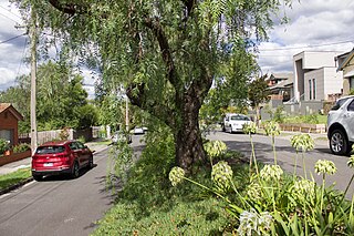
Kew (;) is an inner suburb of Melbourne, Victoria, Australia, 5 km east from Melbourne's Central Business District, located within the City of Boroondara local government area. Kew recorded a population of 24,499 at the 2021 census.
The City of Gosford is a former local government area located on the Central Coast region, in the state of New South Wales, Australia. The incorporation of Gosford dates back to 1886 when the Town of Gosford was proclaimed as the Borough of Gosford, becoming the Municipality of Gosford from 1906. In 1908, the Gosford Municipality merged into Erina Shire which covered the remaining Central Coast area outside of Gosford, but regained its independence in 1936. From 1 January 1947, local government in the Central Coast region was reorganised, creating Gosford Shire and Wyong Shire, and the final boundaries of Gosford City Council date from this period. From 1 January 1980, Gosford Shire was granted city status, becoming the City of Gosford. On 12 May 2016 the Minister for Local Government amalgamated the City of Gosford and Wyong Shire Councils. The Central Coast Council was established on the same day, covering the combined areas.
Wyong Shire was a local government area located in the Central Coast region of New South Wales, Australia. The incorporation of the Wyong area dates back to 7 March 1906 when the entire area of the Brisbane Water Police District outside of the Town of Gosford was proclaimed as the Erina Shire. From 1 January 1947, local government in the Central Coast region was reorganised, creating Gosford Shire and Wyong Shire, which comprised Erina Shire north and east of Kulnura, Central Mangrove and Lisarow.
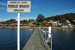
Saratoga is a residential south-eastern village and suburb of the Central Coast region of New South Wales, Australia, located on a peninsula of Brisbane Water and part of the Central Coast Council local government area. The suburb is characterised by its largely settled shoreline, with houses extending up coastal slopes to the base of the tall hills that comprise the core of the peninsula.
Narara is a suburb just north of Gosford on the Central Coast region of New South Wales, Australia. It is part of the Central Coast Council local government area.
Erina is a suburb located in the Central Coast region of New South Wales, Australia between Gosford and the Pacific Ocean at Terrigal. It is part of the Central Coast Council local government area.
The Entrance is a coastal town and suburb in the Central Coast region of New South Wales, Australia. It is part of the Central Coast Council local government area. At the 2011 census, The Entrance had a population of 3,873 people.
Woy Woy is a coastal town in the Central Coast region of New South Wales, Australia, located on the southern reaches of Brisbane Water 79 km (49 mi) north of Sydney. It is a population centre within the Central Coast Council local government area.
Gosford railway station is located on the Main Northern line in New South Wales, Australia. It serves the Central Coast city of Gosford, opening on 15 August 1887.
Avoca Beach is a coastal suburb of the Central Coast region of New South Wales, Australia, about 95 kilometres (59 mi) north of Sydney. Avoca Beach is primarily a residential suburb, which is now often considered part of the Greater Sydney area, but also a popular tourist destination. Avoca Beach village has a variety of restaurants and cafes as well as a post office, newsagent, pharmacy and mini-mart. Avoca Beach also has a historic cinema, a hotel, bowling club, motel and caravan park. It is located within the Central Coast Council local government area.
Erina Heights is a suburb of the Central Coast region of New South Wales, Australia between Gosford and the Pacific Ocean at Terrigal. It is part of the Central Coast Council local government area.
Holgate is a semi-rural suburb of the Central Coast region of New South Wales, Australia north-east of Gosford. It is part of the Central Coast Council local government area.
The Central Coast Highway is a 50-kilometre (31 mi) highway through the Central Coast region of New South Wales, Australia. It connects the Pacific Motorway (M1) at Kariong with the Pacific Highway (A43) at Doyalson. The highway is named after the region it goes through, The Central Coast. It was officially named by the New South Wales state government on 9 August 2006 to provide an easily identifiable route for visitors to the region.
The Erina Eagles are an Australian rugby league football club based in the suburb of Erina on the Central Coast of NSW. They have numerous teams competing in competitions run by the Central Coast Division of Country Rugby League, from U/7s through to First Grade. The Eagles' current home ground is Erina Oval and their traditional colours are red, white and blue.
The Central Coast Council is a local government area serving the Lower Hunter area and the Central Coast region of New South Wales, Australia, established on 12 May 2016 following the amalgamation of Gosford City and Wyong Shire councils.
This article provides information on the under 16 premiership deciders of rugbyleague competitions held on the Central Coast of New South Wales, Australia. The Match Details sub-section details the individual point-scorers in a match, where known.
This page is based on this Wikipedia article Text is available under the CC BY-SA 4.0 license; additional terms may apply. Images, videos and audio are available under their respective licenses.