North Gosford, New South Wales

Last updated

North Gosford
Central Coast,  New South Wales
Population3,700 (2016 census) [1]
 • Density1,900/km2 (4,800/sq mi)
Postcode(s) 2250
Area2 km2 (0.8 sq mi)
Location2 km (1 mi) N of Gosford
LGA(s) Central Coast Council
Parish Gosford
State electorate(s) Gosford
Federal Division(s) Dobell, Robertson
Suburbs around North Gosford:
Narara Wyoming Mount Elliot
Gosford North Gosford Springfield
Gosford East Gosford Springfield

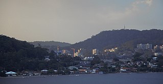
North Gosford is a south-eastern suburb of the Central Coast region of New South Wales, Australia immediately north-east of Gosford's central business district. It is part of the Central Coast Council local government area.

Central Coast (New South Wales) City in New South Wales, Australia

The City of Central Coast, a peri-urban region in the Australian state of New South Wales (NSW), lies on the Tasman Sea coast on the northern outskirts of Sydney and south of Lake Macquarie.

New South Wales State of Australia

New South Wales is a state on the east coast of Australia. It borders Queensland to the north, Victoria to the south, and South Australia to the west. Its coast borders the Tasman Sea to the east. The Australian Capital Territory is an enclave within the state. New South Wales' state capital is Sydney, which is also Australia's most populous city. In December 2018, the population of New South Wales was over 8 million, making it Australia's most populous state. Just under two-thirds of the state's population, 5.1 million, live in the Greater Sydney area. Inhabitants of New South Wales are referred to as New South Welshmen.

Central business district

A central business district (CBD) is the commercial and business center of a city. In larger cities, it is often synonymous with the city's "financial district". Geographically, it often coincides with the "city centre" or "downtown", but the two concepts are separate: many cities have a central business district located away from its commercial or cultural city centre or downtown, or even several CBDs at once. In London, for example, the "city centre" is usually regarded as encompassing the historic City of London and the mediaeval City of Westminster, whereas the City of London and the transformed Docklands area are regarded as its two CBDs. In New York City, Midtown Manhattan is the largest central business district in the city and in the world; yet Lower Manhattan, commonly called Downtown Manhattan, represents the second largest, and second, distinct CBD in New York City and is geographically situated south of Midtown. In Chicago, the Chicago Loop is the second largest central business district in the United States and is also referred to as the core of the city's downtown. Mexico City also has a historic city centre, the colonial-era Centro Histórico, along with two CBDs: the mid-late 20th century Paseo de la Reforma – Polanco, and the new Santa Fe.

North Gosford is notable for the region's largest private hospital and for Laycock Street Theatre, the region's principal theatre for live dramatic and musical theatre.

Theatre Collaborative form of performing art

Theatre or theater is a collaborative form of fine art that uses live performers, typically actors or actresses, to present the experience of a real or imagined event before a live audience in a specific place, often a stage. The performers may communicate this experience to the audience through combinations of gesture, speech, song, music, and dance. Elements of art, such as painted scenery and stagecraft such as lighting are used to enhance the physicality, presence and immediacy of the experience. The specific place of the performance is also named by the word "theatre" as derived from the Ancient Greek θέατρον, itself from θεάομαι.

Related Research Articles

Gosford Suburb of Central Coast, New South Wales, Australia

Gosford is a New South Wales suburb located in the heart of the Central Coast Region, about 76 kilometres (47 mi) north of the Sydney CBD. The suburb is situated at the northern extremity of Brisbane Water, an extensive northern branch of the Hawkesbury River estuary and Broken Bay.

Saratoga, New South Wales Suburb of Central Coast, New South Wales, Australia

Saratoga is a residential south-eastern village and suburb of the Central Coast region of New South Wales, Australia, located on a peninsula of Brisbane Water and part of the Central Coast Council local government area. The suburb is characterised by its largely settled shoreline, with houses extending up coastal slopes to the base of the tall hills that comprise the core of the peninsula.

Niagara Park, New South Wales Suburb of Central Coast, New South Wales, Australia

Niagara Park is a suburb of the Central Coast region of New South Wales, Australia 6 kilometres (4 mi) north of Gosford's central business district. It is part of the Central Coast Council local government area. It consists of residential housing as well as acreage blocks and small farms with many houses backing onto natural bushland and reserves. It is close to the M1 and is 20 minutes from Shelly Beach. A peaceful community with rural aspects and a large technology driven primary school, Niagara Park is ideal for families with young children.

Shelly Beach, Central Coast New South Wales Suburb of Central Coast, New South Wales, Australia

Shelly Beach is a coastal suburb of the Central Coast region of New South Wales, Australia, located east of Tuggerah Lake and bordering the Pacific Ocean south of The Entrance. It is part of the Central Coast Council local government area. It is 66 km south of Newcastle & 93 km north of Sydney. Shelly Beach is considered one of the most popular surfing beaches on the Central Coast.

Box Head, New South Wales Suburb of Central Coast, New South Wales, Australia

Box Head is a not a suburb but a coastal locality of the Central Coast region of New South Wales, Australia in the Central Coast Council local government area.

Cheero Point, New South Wales Suburb of Central Coast, New South Wales, Australia

Cheero Point is a residential suburb of the Central Coast region of New South Wales, Australia, located on the west bank of the Mooney Mooney Creek 49 kilometres (30 mi) north of Sydney. It is part of the Central Coast Council local government area.

East Gosford, New South Wales Suburb of Central Coast, New South Wales, Australia

East Gosford is a suburb of the Central Coast region of New South Wales, Australia, located immediately southeast of Gosford's town centre. It is part of the Central Coast Council local government area, and occupies an area previously inhabited by the Guringai (Wanangine) People. East Gosford is named after the Archibald Acheson, 2nd Earl of Gosford, with whom New South Wales Governor George Gipps served in Canada. Archibald Acheson was appointed Governor of British North America in 1835, and conducted a royal commission into the state of affairs in Lower Canada.

Holgate is a semi-rural suburb of the Central Coast region of New South Wales, Australia north-east of Gosford. It is part of the Central Coast Council local government area.

Koolewong, New South Wales Suburb of Central Coast, New South Wales, Australia

Koolewong is a suburb of the Central Coast region of New South Wales, Australia between Gosford and Woy Woy, and is mostly on a hill overlooking Brisbane Water. It is part of the Central Coast Council local government area.

Patonga is a suburb of the Central Coast region of New South Wales, Australia, located on the north bank of the Hawkesbury River, southwest of Woy Woy. It is part of the Central Coast Council local government area.

Point Clare is a suburb of the Central Coast region of New South Wales, Australia located 4 kilometres (2 mi) south-west of Gosford's central business district on the western shore of Brisbane Water. It is part of the Central Coast Council local government area.

Point Frederick, New South Wales Suburb of Central Coast, New South Wales, Australia

Point Frederick is a suburb of the Central Coast region of New South Wales, Australia on a peninsula protruding into Brisbane Water 2 kilometres (1 mi) south-southeast of Gosford's central business district. It is part of the Central Coast Council local government area.

St Huberts Island, New South Wales Suburb of Central Coast, New South Wales, Australia

St Huberts Island is a canal estate and suburb of the Central Coast region of New South Wales, Australia connected to the mainland at Daleys Point. It is part of the Central Coast Council local government area.

Spencer, New South Wales Suburb of Central Coast, New South Wales, Australia

Spencer is a suburb of the Central Coast region of New South Wales, Australia. It is located on the north bank of the Hawkesbury River just upstream of that river's confluence with Mangrove Creek. Spencer is part of the Central Coast Council local government area.

Tascott, New South Wales Suburb of Central Coast, New South Wales, Australia

Tascott is a suburb of the Central Coast region of New South Wales, Australia between Gosford and Woy Woy on Brisbane Water's western shore. It is part of the Central Coast Council local government area.

Yattalunga is a south-eastern suburb of the Central Coast region of New South Wales, Australia. It is part of the Central Coast Council local government area.

Greengrove is a locality of and town within the Central Coast region of New South Wales, Australia, near Mangrove Mountain and adjoining the Popran National Park about 40 kilometres (25 mi) west of Gosford. It is part of the Central Coast Council local government area.

Lower Mangrove is a suburb of the Central Coast region of New South Wales, Australia, located about 8 kilometres (5 mi) upstream and north of Spencer along Mangrove Creek. It is part of the Central Coast Council local government area.

Mangrove Creek is a suburb of the Central Coast region of New South Wales, Australia, located about 14 kilometres (9 mi) upstream and north of Spencer along the Mangrove Creek watercourse. It is part of the Central Coast Council local government area.

References

  1. Australian Bureau of Statistics (27 June 2017). "North Gosford (State Suburb)". 2016 Census QuickStats. Retrieved 19 March 2018. OOjs UI icon edit-ltr-progressive.svg

Coordinates: 33°24′54″S151°21′04″E / 33.415°S 151.351°E / -33.415; 151.351

Geographic coordinate system Coordinate system

A geographic coordinate system is a coordinate system that enables every location on Earth to be specified by a set of numbers, letters or symbols. The coordinates are often chosen such that one of the numbers represents a vertical position and two or three of the numbers represent a horizontal position; alternatively, a geographic position may be expressed in a combined three-dimensional Cartesian vector. A common choice of coordinates is latitude, longitude and elevation. To specify a location on a plane requires a map projection.