
The City of Central Coast, a peri-urban region in the Australian state of New South Wales (NSW), lies on the Tasman Sea coast on the northern outskirts of Sydney and south of Lake Macquarie.

Wyong is a town of the Central Coast region of New South Wales, located approximately 63 km SSW of Newcastle and 89 km NNE of Sydney. Established in 1888, it is one of the two administrative centres for the Central Coast Council local government area.

Tuggerah Lake, an intermittently open intermediate wave dominated barrier estuary that is part of the Tuggerah Lakes, is located within the Central Coast Council local government area in the Central Coast region of New South Wales, Australia. The lake is located near Wyong and is situated about 90 kilometres (56 mi) north of Sydney.

Wyong Shire was a local government area located in the Central Coast region of New South Wales, Australia, north of Sydney.

Toukley is a town in the Central Coast region of the Australian state of New South Wales and is located within Central Coast Council. It lies approximately 107 km north of Sydney via the M1. It is located between Tuggerah Lake, Budgewoi Lake, and the Pacific Ocean. At the channel connecting Tuggerah Lake and Budgewoi Lake the new Toukley bridge was constructed between 1983 and 1985 linking Toukley on the eastern side of the Lakes system with Gorokan on the west, replacing the old two lane wooden bridge.

The Entrance is a district centre and town in the Central Coast region of New South Wales, Australia. It is part of the Central Coast Council local government area. At the 2011 census, The Entrance had a population of 3,873 people.

Wyong railway station is located on the Main Northern line in New South Wales, Australia. It serves the northern Central Coast suburb of Wyong.

Kanwal is a suburb of the Central Coast region of New South Wales, Australia. It is part of the Central Coast Council local government area and is approximately 90 km north of Sydney, 55 km south of Newcastle and 6 km west of the Pacific Ocean.

Tuggerah railway station is located on the Main Northern line in New South Wales, Australia. It serves the northern Central Coast suburb of Tuggerah, opening in 1890. A pair of passing loops were added north of the station in 1948. These were removed in December 1995. The station was rebuilt in the 1990s.

Niagara Park railway station is located on the Main Northern line in New South Wales, Australia. It serves the northern Central Coast suburb of Niagara Park opening in October 1902 as Tundula. On 27 November 1902 it was renamed Niagara Park.

Gosford railway station is located on the Main Northern line in New South Wales, Australia. It serves the Central Coast city of Gosford, opening on 15 August 1887.
Tuggerah is a developing suburb of the Central Coast region of New South Wales, Australia, situated on the Main North Line railway and Sydney-Newcastle Freeway approximately 90 km north of Sydney. It is the Business Hub, Major Shopping Area and Financial District for the Central Coast Council. It is a mixture of semi-rural, Residential, and light industrial. Historically it was, like much of the Wyong District a dairy area, which currently still has the Pioneer Dairy Wetlands. There was an airstrip for some years which has now been built over. The Wyong South sewerage plant is also located in Tuggerah.
Westfield Tuggerah is a shopping centre located at Tuggerah on the Central Coast of New South Wales, Australia approximately 2 km south of the Wyong town centre. The complex was opened in 1995. The centre completed an expansion in 2005 and contains 245 stores and 8 cinemas. It is currently the second largest enclosed shopping centre on the Central Coast after Erina Fair, and is fourth largest shopping area after Gosford, Erina, and The Entrance based on store numbers.

Long Jetty is a suburb of the Central Coast region of New South Wales, Australia, located on a peninsula between Tuggerah Lake and the Pacific Ocean south of The Entrance. It is part of the Central Coast Council local government area.
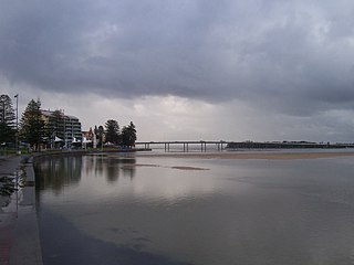
The Entrance Bridge is a 467-metre long (1,532 ft) concrete girder bridge with 18 spans across the Tuggerah Lakes and joins the towns of The Entrance and The Entrance North, located on the Central Coast of New South Wales, Australia. The bridge passes over The Entrance Channel leading into the Tuggerah Lakes and carries road traffic across Wilfred Barret Drive as part of the Central Coast Highway, as well as a grade-separated pedestrian footpath and cycleway.

The Tuggerah Lakes, a wetland system of three interconnected coastal lagoons, are located on the Central Coast of New South Wales, Australia and comprise Lake Munmorah, Budgewoi Lake and Tuggerah Lake.
Budgewoi is a suburb located on the Central Coast of New South Wales, Australia, as part of the Central Coast Council local government area. Budgewoi is located 112 km by road north of the Sydney central business district.

Killarney Vale is a suburb of the Central Coast region of New South Wales, Australia, located approximately 5 kilometres south of The Entrance. It is part of the Central Coast Council local government area.

Toowoon Bay is a suburb of the Central Coast region of New South Wales, Australia, located on a peninsula between Tuggerah Lake and the Pacific Ocean south of The Entrance. It is part of the Central Coast Council local government area.
Wyongah is a suburb of the Central Coast region of New South Wales, Australia. It is part of the Central Coast Council local government area.
