Gosford is the city and administrative centre of the Central Coast Council local government area in the heart of the Central Coast region, about 76 kilometres (47 mi) north of Sydney and about 91 kilometres (57 mi) south of Newcastle. The city centre is situated at the northern extremity of Brisbane Water, an extensive northern branch of the Hawkesbury River estuary and Broken Bay.

The Central Coast is a peri-urban region in New South Wales, Australia, lying on the Tasman Sea coast to the north of Sydney and south of Newcastle.

Wyong is a town in the Central Coast of New South Wales, located approximately 63 km SSW of Newcastle and 89 km NNE of Sydney. Established in 1888, it is one of the two administrative centres for the Central Coast Council local government area.

Kincumber is a south-eastern suburb of the Central Coast region of New South Wales, Australia, nested between the Kincumba Mountain Reserve and the Kincumber Broadwater and located 87 kilometres (54 mi) north of Sydney via the Sydney-Newcastle Freeway (F3). It is part of the Central Coast Council local government area. It is on The Guringgai land

Erina is a suburb located in the Central Coast region of New South Wales, Australia between Gosford and the Pacific Ocean at Terrigal. It is part of the Central Coast Council local government area.

Joondalup is a suburb of Perth, Western Australia, approximately 26 kilometres (16 mi) north of Perth's central business district. It contains the central business district of the regional City of Joondalup and acts as the primary urban centre of Perth's outer northern suburbs.
Bateau Bay is a suburb of the Central Coast region of New South Wales, Australia. It is part of the Central Coast Council local government area. Bateau Bay lies in the area known as Darkinjung to Indigenous Australians. "Bateau" is French for "boat." The suburb was previously known as Boat Harbour but it was changed to the French version as a marketing activity in the 1970s.

Wyoming is a suburb of the Central Coast region of New South Wales, Australia, located 4 kilometres (2 mi) northeast of Gosford's central business district. It is part of the Central Coast Council local government area.

Cardiff is a small town in the Lake Macquarie LGA of New South Wales, Australia.

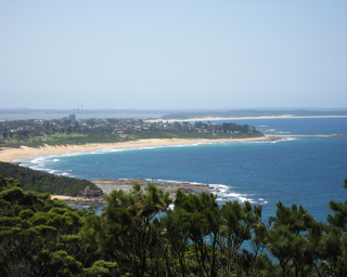
Terrigal is a coastal town in the Central Coast of New South Wales, Australia, located 12 kilometres (7 mi) east of Gosford on the Pacific Ocean. It is part of the Central Coast Council local government area.
Kulnura is a suburb of the Central Coast region of New South Wales, Australia, located north of Mangrove Mountain along George Downes Drive. It is within Central Coast Council local government area. Kulnura's name is an Aboriginal word meaning "in sight of the sea" or "up in the clouds", it was named in 1914 by a meeting of the early pioneers Messrs Archibold, Collins, Gatley, Penn, Young, Williams and Gibson. Its population of approximately 600 people rely mostly on the town's fruit and cattle industries for income, however many commute to regional centres of Gosford, Wyong and even to Sydney for work. It is also home to the biggest catchment area on the Central Coast, Mangrove Creek Dam which has a capacity of 190 000 ML, and has a free tourist kiosk on the site. "Mangrove Mountain Bottlers Pty Ltd" bottle still water at their plant at Kulnura, as well as for private label mass-retailers, such as 7–11.

Daleys Point is a south-eastern suburb of the Central Coast region of New South Wales, Australia on the Bouddi Peninsula. It is part of the Central Coast Council local government area. The median house price in January 2010 was A$950,000.

Davistown is a south-eastern suburb of the Central Coast region of New South Wales, Australia. It is part of the Central Coast Council local government area.

East Gosford is a suburb of the Central Coast region of New South Wales, Australia, located immediately south-east of Gosford's town centre. It is part of the Central Coast Council local government area, and occupies an area previously inhabited by the Guringai (Wanangine) People. East Gosford is named after the Archibald Acheson, 2nd Earl of Gosford, with whom New South Wales Governor George Gipps served in Canada. Archibald Acheson was appointed Governor of British North America in 1835, and conducted a royal commission into the state of affairs in Lower Canada.
Erina Heights is a suburb of the Central Coast region of New South Wales, Australia between Gosford and the Pacific Ocean at Terrigal. It is part of the Central Coast Council local government area.

Ettalong Beach is a suburb of the Central Coast region of New South Wales, Australia south of Woy Woy on Brisbane Water at the point where it meets Broken Bay, about 80 km north of Sydney. It is part of the Central Coast Council local government area. Ettalong Beach is the natural eastward continuation of Umina Beach and Ocean Beach. The village is serviced by a small retail centre along Ocean View Road.

Kariong is a locality of the Central Coast region of New South Wales, Australia west of Gosford along the Central Coast Highway. It is part of the Central Coast Council local government area.

Killcare is a south-eastern suburb of the Central Coast region of New South Wales, Australia, located on the Bouddi Peninsula. It is part of the Central Coast Council local government area.

The Ponds is a suburb of Sydney, in the state of New South Wales, Australia. The Ponds is located approximately 40 kilometres (25 mi) west-northwest (WNW) of the Sydney central business district in the Blacktown local government area. At the 2016 census, The Ponds had an estimated resident population of 11,731.
Blue Haven is a suburb on the Central Coast of New South Wales, Australia, located on Pacific Highway at Wallarah Creek. Its local government area is Central Coast Council.