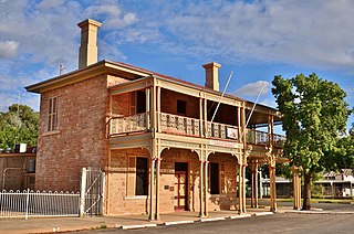
Conargo is a town in the Riverina region of New South Wales, Australia. The town is in the Edward River Council local government area. It is on Billabong Creek, a tributary of the Edward River. The nearest towns are Jerilderie and Deniliquin. At the 2006 census, Conargo had a population of 117 people.

Murrumbidgee Shire was a local government area in the Riverina region of south western New South Wales, Australia. The Shire was located adjacent to the Murrumbidgee River and the Newell Highway.

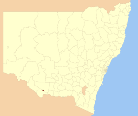
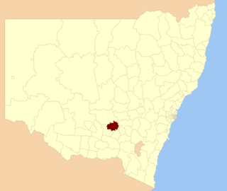
Conargo Shire was a local government area in the Riverina region in southern New South Wales, Australia.

The Palerang Council was a local government area located in the Southern Tablelands region of New South Wales, Australia. On 12 May 2016 the Minister for Local Government announced dissolution of the Palerang Council with immediate effect. Together with Queanbeyan City the combined council areas were merged to establish the Queanbeyan-Palerang Regional Council. Both councils had opposed the amalgamation. Elections for the new Council area were held in September 2017. The former mayor of Queanbeyan City Council was appointed by the New South Wales Government as administrator until that date.

Murray Shire was a local government area in the Riverina region of south western New South Wales, Australia. It included the towns of Moama and Mathoura. It was abolished on 12 May 2016 and its area merged with the Wakool Shire to establish the Murray River Council.

The Carrathool Shire is a local government area that borders both the Riverina and Far West regions of New South Wales, Australia. The Shire comprises 18,933 square kilometres (7,310 sq mi) and is located adjacent to the Mid-Western Highway and north of the Sturt Highway.
Central Darling Shire is a local government area in the Far West region of New South Wales, Australia. The Shire is located adjacent to the Barrier Highway. Central Darling Shire was constituted in 1959 and at 53,511 square kilometres (20,661 sq mi), it is the largest incorporated local government area in New South Wales.

Wakool Shire was a local government area in the Riverina region of New South Wales, Australia. The Shire was located between the Murray River and the Murrumbidgee River and adjacent to the Sturt Highway. Towns in the Shire are Barham, Moulamein, Tooleybuc, Wakool and Koraleigh.

Berrigan Shire is a local government area in the southern Riverina region of New South Wales, Australia. The Shire lies on the New South Wales State border with Victoria formed by the Murray River. The Shire is adjacent to the Newell and Riverina Highways. The Shire is a mainly agricultural region, with dairying, cattle raising, woolgrowing and cropping the main activities. The vast majority of the Shire is irrigated. Tourism is another major activity, concentrated on the river towns of Tocumwal and Barooga.

Gundagai Shire was a local government area in the Riverina region of New South Wales, Australia. On 12 May 2016, Gundagai Shire was abolished and merged with the neighbouring Cootamundra Shire to establish Cootamundra-Gundagai Regional Council.

The Bombala Shire was a local government area in the Monaro region of south-eastern New South Wales, Australia. The Shire includes the town of Bombala, the villages of Delegate, Cathcart, Bibbenluke and the localities of Ando, Bungarby, Craigie, Mila, Rockton and Creewah. Bombala Shire was formed on 1 October 1977 by the amalgamation of the Municipality of Bombala and Bibbenluke Shire.

Dungog Shire is a local government area in the Hunter region of New South Wales, Australia. The Shire is situated adjacent to the Barrington Tops and consists predominantly of very rugged to hilly country which becomes less rugged from north to south.

Tumbarumba Shire was a local government area in the eastern Riverina region, located in the foothills of the Snowy Mountains, on the upper reaches of the Murray River in New South Wales, Australia. It came into existence in 1906. Prior to this the area covered by the shire was unincorporated. It included the town of Tumbarumba and the small towns of Rosewood, Tooma, Khancoban and Jingellic.
Temora Shire is a local government area in the Riverina region of New South Wales, Australia. It is on Burley Griffin Way. The Shire was created on 1 January 1981 via the amalgamation of Narraburra Shire and the Municipality of Temora.

Lockhart Shire is a local government area in the Riverina region of New South Wales, Australia. The Shire was created in 1906 and is an agricultural and pastoral area.

Urana Shire was a local government area in the Riverina region of New South Wales, Australia. The Newell Highway crosses its north-west corner. The Shire included the town of Urana and the small towns of Boree Creek, Morundah, Oaklands and Rand.

Corowa Shire was a local government area in the Riverina region in southern New South Wales, Australia. The area was located adjacent to the Murray River and the Riverina Highway.

Adam Alexander Armstrong, OBE, MC, commonly known as Bill Armstrong, was an Australian politician. Born in Deniliquin, New South Wales, he was a grazier before serving in the military 1939–45. Subsequently, he became involved in local politics, serving on Conargo Shire Council. In 1965 he was elected to the Australian House of Representatives in the by-election for the seat of Riverina that followed the resignation of Hugh Roberton; Armstrong was a member of the Country Party. He held the seat until 1969, when he was defeated by Labor's Al Grassby. Armstrong died in 1982.

The Edward River Council is a local government area in the Murray region of New South Wales, Australia. This area was formed in 2016 from the merger of the Deniliquin Council with the surrounding Conargo Shire.
Windouran Shire was a local government area in the Riverina region of New South Wales, Australia.