Related Research Articles

There are 137 local government areas of Western Australia (LGAs), which are areas, towns and districts in Western Australia that manage their own affairs to the extent permitted by the Local Government Act 1995. The Local Government Act 1995 also makes provision for regional local governments (referred to as "regional councils", established by two or more local governments for a particular purpose.

The City of Wyndham is a local government area in Victoria, Australia in the outer south-western suburbs of Melbourne, within the Melbourne Metropolitan Area, between Melbourne and the regional city of Geelong. It has an area of 542 square kilometres (209 sq mi). The city had a population of 255,322 in June 2018. For the year to 2018 the City of Wyndham increased its population by 14,251, the largest number of any LGA in Victoria, as well as being the second most populous and the second fastest growing at a rate of 5.9 per cent.
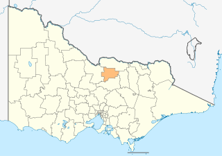
The City of Greater Shepparton is a local government area in the Hume region of Victoria, Australia, located in the north-east part of the state. It covers an area of 2,422 square kilometres (935 sq mi) and, in June 2018, had a population of 66,007. It includes the city of Shepparton and the towns of Arcadia, Ardmona, Congupna, Dookie, Grahamvale, Kialla, Lemnos, Merrigum, Mooroopna, Murchison, Tallygaroopna, Tatura, Toolamba and Undera. It was formed in 1994 from the amalgamation of the City of Shepparton, Shire of Shepparton, and parts of the Shire of Rodney, Shire of Euroa, Shire of Goulburn, Shire of Tungamah, Shire of Violet Town and Shire of Waranga.

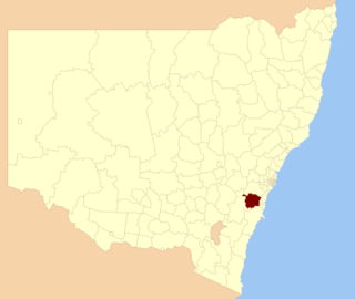
The City of Hawkesbury is a local government area of New South Wales, Australia, the City of Hawkesbury is located on the North and North Western edge of the Greater Sydney region and is adjacent to the Sydney metropolitan area, about 50 kilometres (31 mi) north-west of the Sydney central business district. Hawkesbury City is named after the Hawkesbury River.

Leeton is a town located in the Riverina region of New South Wales, Australia. Leeton is situated in the Murrumbidgee Irrigation Area. It is the administrative centre of the Leeton Shire Council local government area, which includes neighbouring suburbs, towns and localities such as Yanco, Wamoon, Whitton, Gogeldrie, Stanbridge and Murrami. Situated in one of the most productive farming regions in the state, the town was designed by Walter Burley Griffin and purpose-built for the irrigation schemes announced by the New South Wales government in the early 20th century. The Leeton Shire possesses numerous citrus, rice, cotton, grape, walnut and wheat farms. Leeton is known as Australia's Rice Capital, as well as The Heart of SunRice Country, as it is home to the headquarters of SunRice corporation, one of Australia's largest food exporters. Other industry includes Arnott’s Biscuits, the Daily Drinks Company, JBS Australia, Webster Limited, and Murrumbidgee Irrigation Limited. Tony Reneker is the current mayor of Leeton.

Irrigation Way is a major rural road that runs approximately 85 kilometres (53 mi) through the Murrumbidgee Irrigation Area in south western New South Wales, Australia.

Wynnum is a coastal suburb in the City of Brisbane, Queensland, Australia. In the 2016 census, Wynnum had a population of 12,915 people. The suburb is a popular destination in Brisbane due to its coastline, jetty and tidal wading pool.
Wingecarribee Shire is the local government area of the Southern Highlands in the state of New South Wales, Australia. The Wingecarribee Shire is around 110 kilometres (70 mi) southwest of Sydney and is part of regional Capital Country and to some extent can be considered part of the Southern Tablelands.

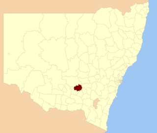
The Junee Shire is a local government area in the Riverina region of New South Wales, Australia. The Shire comprises an area of 2,030 square kilometres (780 sq mi) and is located adjacent to the Olympic Highway and the Main South railway line. It was formed on 1 January 1981 from the amalgamation of the Municipality of Junee and Illabo Shire resulting from the Local Government Areas Amalgamation Act 1980.
Temora Shire is a local government area in the Riverina region of New South Wales, Australia. It is on Burley Griffin Way. The Shire was created on 1 January 1981 via the amalgamation of Narraburra Shire and the Municipality of Temora.

The Shire of Winton is a local government area in Central West Queensland, Australia. It covers an area of 53,814 square kilometres (20,777.7 sq mi), and has existed as a local government entity since 1887. Its administrative centre is located in the town of Winton. It is named after Winton, Dorset, England, the birthplace of Robert Allen, the first white settler in the Winton (Queensland) area.

The Shire of Boulia is a local government area in Central West Queensland, bordering the Northern Territory. Its administrative centre is in the town of Boulia.

The Shire of Hinchinbrook is a local government area in North Queensland, Queensland, Australia. The shire, administered from the town of Ingham, covers an area of 2,807 square kilometres (1,083.8 sq mi), and has existed since its creation on 11 November 1879 as one of 74 divisions around Queensland under the Divisional Boards Act 1879.
The Shire of Laidley was a local government area located in the Lockyer Valley region between the cities of Toowoomba and Ipswich, and about 70 kilometres (43 mi) west of Brisbane, the state capital of Queensland, Australia. The shire covered an area of 700.6 square kilometres (270.5 sq mi), and existed from 1888 until its merger with the Shire of Gatton to form the Lockyer Valley Region on 15 March 2008.
The Shire of Dandaragan is a local government area located in the Wheatbelt region of Western Australia, about 200 kilometres (124 mi) north of the state capital, Perth. The Shire covers an area of 6,716 square kilometres (2,593 sq mi) and its seat of government is the town of Jurien Bay.
Barrengarry is a small village near the Southern Highlands of New South Wales, Australia, in City of Shoalhaven. It is situated north of Kangaroo Valley. At the 2021 census, it had a population of 214.
Murray is an electoral district in the Australian state of New South Wales.
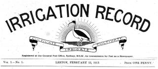
The Irrigation Record was a fortnightly newspaper published in Leeton, New South Wales, Australia from 15 February 1913 to 15 June 1917 by the NSW Water Conservation and Irrigation Commission. Its purpose was to educate new settlers of the fledgling Murrumbidgee Irrigation Area (MIA), about agricultural methods, irrigation techniques, crops, stock and machinery.

The Shire of Balmoral is a former local government area of Queensland, Australia, located in eastern Brisbane.
References
- ↑ "Wade Shire (1928-1981) / Griffith Shire (1981-1987) / Griffith City Council (1987- )". Research Data Australia. Retrieved 2022-11-18.
- ↑ Society, Griffith Genealogical and Historical (2019-11-12). "Growing pains of young Wade Shire". The Area News. Retrieved 2022-11-18.
| | This New South Wales geography article is a stub. You can help Wikipedia by expanding it. |