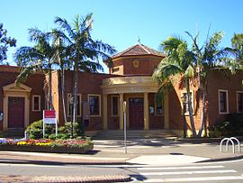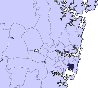
Municipality of Erskineville New South Wales | |||||||||||||||
---|---|---|---|---|---|---|---|---|---|---|---|---|---|---|---|
Population | 6,881 (1947 census) [1] | ||||||||||||||
• Density | 1,966/km2 (5,090/sq mi) | ||||||||||||||
Established | 23 May 1872 | ||||||||||||||
Abolished | 31 December 1948 | ||||||||||||||
Area | 3.5 km2 (1.4 sq mi) | ||||||||||||||
Council seat | Erskineville Town Hall | ||||||||||||||
Region | Inner West | ||||||||||||||
County | Cumberland | ||||||||||||||
Parish | Petersham | ||||||||||||||
|
The Municipality of Erskineville was a local government area of Sydney, New South Wales, Australia. The municipality was proclaimed as the "Municipal District of Macdonald Town" on 23 May 1872 and, with an area of 0.8 square kilometres, was one of the smallest local government areas in Sydney and included the modern suburb of Erskineville, part of Eveleigh and the locality of Macdonaldtown. The council was amalgamated, along with most of its neighbours, with the City of Sydney to the north with the passing of the Local Government (Areas) Act 1948 . From 1968 to 1982 and from 1989 to 2004, the area was part of the South Sydney councils, with the former Town Hall serving as its council chambers.
The municipality was proclaimed by the Administrator of the Government of New South Wales, Sir Alfred Stephen, on 23 May 1872, with the name of the Municipal District of Macdonald Town (but was variously known as the "Borough of Macdonald Town" or the "Municipality of Macdonaldtown"). [2] On 19 July 1872, the first council, consisting of six aldermen in one electorate, was elected (Charles Brandling Henderson, Henry Knight, James Bryan, Alexander Swanson, William Irwin and James Heighington), with Henry Knight elected as the first mayor at the first meeting on 23 July 1872. [3] [4] Knight (1801–1887) was a prominent landowner, builder and brick-maker who had also served as an alderman for Kingston Ward on the first council of the Municipality of Newtown when it was created in February 1863, serving until 1866. [5]
The council first met in a weatherboard cottage on Erskineville Road, which was replaced by a purpose-built Victorian style design Town Hall designed by architects, Drake and Walcott, who had also designed the Leichhardt Town Hall and were commissioned by the council in March 1889. [6] Built by Thomas Johnson, of Ultimo, the hall was completed in 1890 and the council first met there in February 1890. [7]
On 19 May 1884, a further proclamation divided the municipality into three wards: North Ward, Middle Ward and South Ward. [8] On 27 March 1893 the Parliament of New South Wales passed the "Borough of Erskineville Naming Act, 1893", effecting the name change from Macdonaldtown to the "Borough of Erskineville". [9] From 28 December 1906, following the passing of the Local Government Act, 1906, the council was again renamed as the "Municipality of Erskineville". With the area being a significant working-class and industrial area, from the late 1910s and 1920s the council was completely controlled by the Australian Labor Party. Non-Labour aldermen were not elected until the 1940s, when Lang Labor eventually took control of the council. [10]
By the 1930s, with the announcement of the widening and realignment of Erskineville Road, the Victorian-era town hall was set to be demolished. As a consequence, Erskineville Council commissioned plans for a new town hall on a site adjacent to the old hall. In 1936, an initial design by Sydney Architect Lindsay Gordon Scott was accepted. This design was an ambitious one, including two stories and a 75-foot-high clock tower. [11] This design however was found to be too expensive and grand for a small municipality in a primarily working-class area of Sydney and was revised to be the current design of a single storey building without the tower in a similar red brick Georgian revival style. On 1 December 1937, the Mayor of the council, Alderman J. W. Elliott, laid the foundation stone and nearly year later, on 26 November 1938, the Secretary for Public Works and Minister for Local Government, Eric Spooner MLA, officially opened Erskineville Town Hall with the Mayor at that time, Alderman Nicholas McGuinness. [12]
By the end of the Second World War, the NSW Government had realised that its ideas of infrastructure expansion could not be effected by the present system of the mostly-poor inner-city municipal councils and the Minister for Local Government, Joseph Cahill, passed a bill in 1948 that abolished a significant number of those councils. Under the Local Government (Areas) Act 1948, Erskineville Municipal Council was merged with the larger neighbouring City of Sydney.
Years | Mayors | Notes |
---|---|---|
23 July 1872 – 13 February 1873 | Henry Knight | [3] [13] |
13 February 1873 – 13 February 1874 | Alexander Swanson | [14] |
13 February 1874 – 13 February 1878 | Charles Brandling Henderson | [15] [16] [17] [18] |
13 February 1878 – 7 February 1880 | Thomas Braid | [19] [20] |
7 February 1880 – 15 February 1882 | Joseph Horsfall | [21] |
15 February 1882 – 14 February 1883 | James Bryan | [22] |
14 February 1883 – 15 February 1884 | Joseph Horsfall | [23] |
15 February 1884 – 14 February 1885 | John Frederick Fallick | [24] |
14 February 1885 – 9 February 1887 | John Goddard | [25] [26] |
9 February 1887 – 14 February 1888 | George Ives | [27] |
14 February 1888 – 8 February 1889 | John Baldwin | [28] |
8 February 1889 – 12 February 1890 | Andrew Murray | [29] |
12 February 1890 – 13 February 1891 | George Ives | [30] |
13 February 1891 – 10 February 1892 | Jacob Jacobsen | [31] |
10 February 1892 – 15 February 1893 | Thomas Carter | [32] |
15 February 1893 – 9 February 1894 | James Peake | [33] |
9 February 1894 – 13 February 1895 | Robert Anderson | [34] |
13 February 1895 – 12 February 1896 | Jacob Jacobsen | [35] |
12 February 1896 – 10 February 1897 | James Peake | [36] |
10 February 1897 – 10 February 1898 | Robert Anderson | [37] |
10 February 1898 – 8 February 1899 | George Crooks Watson | [38] |
8 February 1899 – 8 February 1902 | Gaius Clarke | [39] [40] [41] |
8 February 1902 – February 1908 | William Robinson | [42] [43] [44] [45] [46] |
February 1908 – February 1911 | William Henry Jackson | [47] [48] |
February 1911 – 20 March 1911 | William Robinson | [49] [50] |
March 1911 – February 1914 | Leopold Frederick Theodore Schuler | [51] |
February 1914 – February 1917 | William Robinson | [52] [53] |
February 1917 – February 1918 | J. Vincent (ALP) | [54] |
February 1918 – February 1919 | Thomas English (ALP) | [55] |
February 1919 – February 1920 | George Ouvrier (ALP) | [56] |
February 1920 – December 1920 | Albert Patrick Henry (ALP) | [57] |
December 1920 – December 1921 | James Higgins (ALP) | [58] |
December 1921 – December 1922 | Thomas English (ALP) | [59] |
December 1922 – December 1923 | Alfred Stevens White (ALP) | [60] |
December 1923 – December 1924 | Albert Patrick Henry (ALP) | [61] [62] |
December 1924 – 21 December 1925 | George Ouvrier (ALP) | [63] |
21 December 1925 – December 1926 | John Patrick McCarthy (ALP) | [64] |
December 1926 – 19 December 1927 | Thomas English (ALP) | [65] [66] |
19 December 1927 – 17 December 1928 | Albert Patrick Henry (ALP) | [67] [68] |
17 December 1928 – December 1929 | Thomas English (ALP) | [69] [70] |
December 1929 – December 1930 | Albert Patrick Henry (ALP) | [71] |
December 1930 – December 1931 | Thomas English (ALP) | [72] |
December 1931 – December 1932 | Albert Patrick Henry (ALP) | [73] |
December 1932 – December 1933 | John William Elliott (ALP) | [74] [75] |
December 1933 – December 1934 | Thomas English (ALP) | [76] |
December 1934 – December 1935 | Albert Patrick Henry (ALP) | [77] [78] |
December 1935 – December 1936 | John Patrick McCarthy (ALP) | [79] [80] |
December 1936 – December 1937 | John William Elliott (ALP) | [81] |
December 1937 – December 1938 | Nicholas McGuinness (ALP) | [82] |
December 1938 – December 1940 | J. J. Rose (ALP) | [83] |
December 1940 – December 1941 | A. J. Miller (ALP) | [84] |
December 1941 – December 1942 | John William Elliott (ALP) | [85] |
December 1942 – December 1943 | Harry Wright (ALP) | [86] |
December 1943 – December 1945 | John Patrick McCarthy (Ind/Lang) | [87] [88] |
December 1945 – December 1946 | M. C. Jordan (Lang) | [89] |
December 1946 – December 1947 | Francisco Pietro Fitzjohn (Lang) | [90] |
December 1947 – 31 December 1948 | W. J. Anderson (Lang) | [91] |
Years | Town Clerk | Notes |
---|---|---|
12 September 1872 – 4 September 1881 | George Kemmis Tarrant | [92] |
September 1881 – 6 December 1882 | Robert Caunter | |
6 December 1882 – 16 April 1883 | Beilby Portus Pell Kemp | [93] |
16 April 1883 – 14 October 1886 | William James Osborne Harman | [94] |
14 October 1886 – 20 December 1886 | Albert Thomas Fitt | [95] |
20 December 1886 – 1 August 1901 | William Falkland Bray | [96] [97] [98] |
6 August 1901 – 18 November 1910 | Arthur Francis Desborough | [99] [100] |
21 November 1910 – March 1918 | John Crosdell Lough | [101] |
17 March 1918 – 24 May 1935 | Harold Knight Mackney | [102] [103] [104] |
22 October 1935 – 1 August 1939 | William Irvine Donald | [105] [106] [107] |
August 1939 – July 1946 | Frank O'Grady | [108] [109] [110] |
July 1946 – 31 December 1948 | E. R. Henry |
The City of Botany Bay was a local government area in the Inner South and South-Eastern region of Sydney, in the state of New South Wales, Australia. The area encompassed the suburbs to the north of Botany Bay, such as Botany. First proclaimed in 1888 as the "Borough of Botany", the council became the "Municipality of Botany" from 1906 to 1996, when it was proclaimed a city as the "City of Botany Bay".
Erskineville is a suburb in the Inner West of Sydney, New South Wales, Australia. It is located 6 kilometres south west of the Sydney central business district and is part of the local government area of the City of Sydney. Erskineville is a diverse suburb homing to a wide variety of ethnicity from its varying Southeast Europe and Aboriginal community. Erskineville is colloquially known as Erko.
Marrickville Council was a local government area located in the Inner West region of Sydney, Australia. It was originally created on 1 November 1861 as the "Municipality of Marrickville". On 12 May 2016, Marrickville Council was forcibly merged with Ashfield and Leichhardt councils into the newly formed Inner West Council.
Waverley Council is a Local government area in the eastern suburbs of Sydney, in the state of New South Wales, Australia. First incorporated on 16 June 1859 as the Municipality of Waverley, it is one of the oldest-surviving local government areas in New South Wales. Waverley is bounded by the Tasman Sea to the east, the Municipality of Woollahra to the north, and the City of Randwick in the south and west. The administrative centre of Waverley Council is located on Bondi Road in Bondi Junction in the Council Chambers on the corner of Waverley Park.
Macdonaldtown was previously a suburb in Sydney, in the state of New South Wales, Australia. The suburb was incorporated Erskineville and Newtown. All that remains of Macdonaldtown's legacy is Macdonaldtown railway station. Macdonaldtown was 4 kilometres south-west of the Sydney central business district, adjacent to the suburbs of Newtown, Eveleigh and Erskineville. Macdonaldtown is informally part of the region of the Inner West.
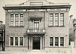
The Municipality of Alexandria was a local government area of Sydney, New South Wales, Australia. Originally part of the municipalities of Redfern from 1859 and Waterloo from 1860, the Borough of Alexandria was proclaimed on 27 August 1868. With an area of 4.2 square kilometres, it included the modern suburbs of Alexandria, Beaconsfield and parts of Eveleigh, St Peters and Erskineville. After a minor boundary change with the Municipality of Erskineville in 1908, the council was amalgamated with the City of Sydney, along with most of its neighbours, with the passing of the Local Government (Areas) Act 1948, although the former council area was later transferred in 1968–1982 and 1989–2004 to the South Sydney councils.
The Municipality of Newtown was a local government area of Sydney, New South Wales, Australia. The municipality was proclaimed as a borough in 1862 and, with an area of 1.9 square kilometres, was centred on the suburb of Newtown, including parts of Erskineville and Enmore. The municipality was divided into four wards: Kingston, Enmore, O'Connell and Camden. In 1949 under the Local Government (Areas) Act 1948, Newtown Municipal Council was merged with the larger neighbouring City of Sydney which was located immediately to the North, although parts were subsequently, from 1968, moved into Marrickville Council. Mayors included Lilian Fowler (1938–1939), the first female mayor in Australia.
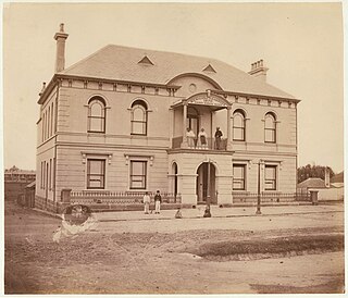
The Municipality of Redfern was a local government area of Sydney, New South Wales, Australia. The small municipality was proclaimed in 1859 as one of the first municipalities proclaimed under the new provisions of the Municipalities Act, 1858, and was centred on the suburbs of Redfern, Eveleigh, Darlington and Surry Hills. The council was amalgamated, along with most of its neighbours, with the City of Sydney to the north with the passing of the Local Government (Areas) Act 1948. From 1968 to 1982 and from 1989 to 2004, the area was part of the South Sydney councils.
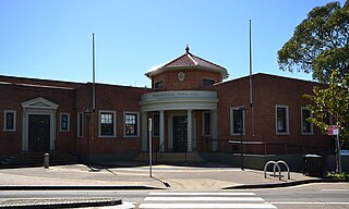
The Erskineville Town Hall is a landmark civic building in Erskineville, a suburb of Sydney. It stands at 104 Erskineville Road. It was opened in 1938 in the Inter-war Mediterranean style by Lindsay Gordon Scott. The Town Hall was the seat of Erskineville Municipal Council from 1938 to 1948 and was the seat of the South Sydney Councils from 1968 to 1982 and 1989 to 2003. Since 2004 the town hall has been a community centre for the City of Sydney servicing the local area and is listed as a heritage item of local significance by the City of Sydney.
The Municipality of Darlington was a local government area of Sydney, New South Wales, Australia. The municipality was proclaimed in 1864 and, with an area of 0.2 square kilometres, was the smallest municipal council in Sydney. It included the entire suburb of Darlington, excepting a small block between Golden Grove and Forbes streets, which was administered by the Municipality of Redfern in Golden Grove Ward. The council was amalgamated, along with most of its neighbours, with the City of Sydney to the north with the passing of the Local Government (Areas) Act 1948. From 1968 to 1982 and from 1989 to 2004, the area was part of the South Sydney councils.
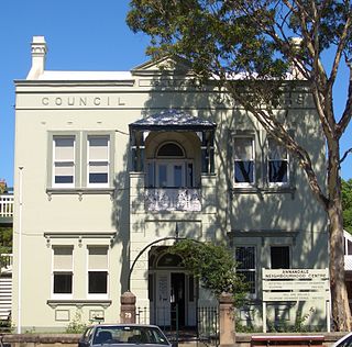
The Municipality of Annandale was a local government area of Sydney, New South Wales, Australia. The municipality was proclaimed on 29 December 1893 as the Borough of Annandale when the East Ward of Leichhardt Council separated, and, with an area of 1.4 square kilometres, covered the entire suburb of Annandale, excepting a small block between Johnstons Creek, Booth Street and Parramatta Road. The council was amalgamated with the Municipality of Leichhardt to the west with the passing of the Local Government (Areas) Act 1948.
The Municipality of Balmain was a local government area of Sydney, New South Wales, Australia. The municipality was proclaimed in February 1860 and, with an area of 3.8 square kilometres, covered the entire peninsula of Balmain north of Callan Park and Foucart Street, including the present suburbs of Balmain, Balmain East, Birchgrove and Rozelle. The council was amalgamated with the municipalities of Leichhardt and Annandale to the south with the passing of the Local Government (Areas) Act 1948.
The Municipality of The Glebe was a local government area of Sydney, New South Wales, Australia. The municipality was proclaimed on 1 August 1859 and, with an area of 2 square kilometres, included the modern suburbs of Glebe and Forest Lodge. The council was amalgamated with the City of Sydney to the east with the passing of the Local Government (Areas) Act 1948, although parts of the former council area were transferred in 1967 to the Municipality of Leichhardt to the west.
The Municipality of Enfield was a local government area of Sydney, New South Wales, Australia. The municipality was proclaimed as the Borough of Enfield on 17 January 1889 and, with an area of 3.6 square kilometres, included the modern suburbs of Croydon, Croydon Park and Strathfield South, with parts of Enfield, Belfield and Greenacre included in the West Ward. In 1949, the council was split into two, with Central and East Wards being added to the Municipality of Burwood and the West Ward being added into the Municipality of Strathfield, with the passing of the Local Government (Areas) Act 1948.
The Municipality of Paddington was a local government area of Sydney, New South Wales, Australia. The municipality was proclaimed on 17 April 1860 and, with an area of 1.7 square kilometres, included the entire suburb of Paddington and parts of Edgecliff. The council was amalgamated with the City of Sydney to the east with the passing of the Local Government (Areas) Act 1948, although the former council area was transferred in 1968 to the Municipality of Woollahra, transferred to the City of South Sydney in 1989 and was then split in 2003 between the City of Sydney and the Municipality of Woollahra.
The Municipality of Mascot was a local government area in the inner south of Sydney, New South Wales, Australia. The municipality was proclaimed as the Borough of North Botany on 29 March 1888 and was renamed to the Municipality of Mascot, in order to differentiate itself from their southern neighbour, from 31 October 1911. It included the modern suburbs of Eastlakes and Daceyville, with parts of Mascot and Pagewood. From 1 January 1949, the council was amalgamated into the Municipality of Botany, with the passing of the Local Government (Areas) Act 1948.
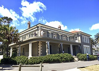
The Municipality of Vaucluse was a local government area of Sydney, New South Wales, Australia. The municipality was proclaimed as the "Borough of Vaucluse" on 1 May 1895, seceding from the Municipality of Woollahra, and included the modern suburbs of Vaucluse and Watsons Bay. The council was re-amalgamated with Woollahra to the south with the passing of the Local Government (Areas) Act 1948.