Murray Shire

Last updated

Murray Shire
New South Wales
Murray LGA NSW.png
Location of the former shire in New South Wales
Coordinates 35°49′S144°54′E / 35.817°S 144.900°E / -35.817; 144.900
Population7,312 (2012) [1]
 • Density1.5/km2 (3.9/sq mi)
Established1906
Abolished12 May 2016 (2016-05-12)
Area4,345 km2 (1,677.6 sq mi)
Mayor Cr. Thomas Weyrich (Independent) [2]
Council seat Mathoura
Region Murray
State electorate(s) Murray
Federal division(s) Farrer
Website Murray Shire
LGAs around Murray Shire:
Conargo Deniliquin Conargo
Wakool Murray Shire Berrigan
Campaspe (Vic) Campaspe (Vic) Moira (Vic)

Murray Shire was a local government area in the Murray region of south western New South Wales, Australia. It included the towns of Moama and Mathoura. It was abolished on 12 May 2016 and its area merged with the Wakool Shire to establish the Murray River Council.

Contents

The last mayor of Murray Shire was Cr. Thomas Weyrich, an independent politician. [2]

History

The Murray Shire region was developed in the 1840s by squatters following the route of the overlanders as they drove cattle from Sydney to Adelaide in the late 1830s. From the 1860s onwards, the selectors, mainly from Victoria, moved onto the squatter's land, their interest agriculture. The settlements of Moama and Mathoura survived over the years as centres for the movement of agriculture produce and the growth of the timber industry. The area covered by the Shire of Murray today is unique. The Cadell Fault, which changed the course of the Murray River about 30,000 years ago traverses the area from north to south. The Murray River system supports one of the largest River Red Gum forests in the world.[ citation needed ]

A 2015 review of local government boundaries by the NSW Government Independent Pricing and Regulatory Tribunal recommended that the Murray Shire merge with the Wakool Shire to form a new council with an area of 11,865 square kilometres (4,581 sq mi) and support a population of approximately 11,500. [3] On 12 May 2016 the Minister for Local Government announced the dissolution of the Murray and Wakool shires and the formation of the Murray River Council with immediate effect. [4]

Council

Shire office at Mathoura. MathouraMurrayShireOffices.JPG
Shire office at Mathoura.

Composition and election method

Prior to its dissolution, the Murray Shire Council was composed of nine councillors elected proportionally as a single ward. All councillors were elected for a fixed four-year term of office. The mayor was elected by the councillors at the first meeting of the council. The most recent and last election was held on 8 September 2012 and the makeup of the former council was as follows: [5]

PartyCouncillors
  Independents and Unaligned9
Total9

The former council, elected in 2012 and dissolved in 2016, in order of election, was: [5]

CouncillorPartyNotes
 Thomas Weyrich Independent Mayor [2]
 Bill AndersonUnaligned
 Brian Sharp OAM Independent
 Betty MurphyIndependent
 Ian MoonIndependent
 Gavin BurkeIndependent
 Gen CampbellIndependent
 John PocklingtonUnalignedDeputy Mayor [2]
 Sue MulcahyIndependent

Related Research Articles

<span class="mw-page-title-main">Jerilderie Shire</span> Former local government area in New South Wales, Australia

Jerilderie Shire was a local government area in the Murray region of southern New South Wales, Australia. The Shire was located adjacent to the Newell Highway. The Shire was declared in 1918 after the amalgamation of the former Municipality of Jerilderie and Wunnamurra Shire. It was dissolved in 2016 after its amalgamation with Murrumbidgee Shire to create Murrumbidgee Council

<span class="mw-page-title-main">Murrumbidgee Shire</span> Former local government area in New South Wales, Australia

Murrumbidgee Shire was a local government area in the Riverina region of south western New South Wales, Australia. The Shire was located adjacent to the Murrumbidgee River and the Newell Highway.

<span class="mw-page-title-main">Palerang Council</span> Former local government area in New South Wales, Australia

The Palerang Council was a local government area located in the Southern Tablelands region of New South Wales, Australia. On 12 May 2016 the Minister for Local Government announced dissolution of the Palerang Council with immediate effect. Together with Queanbeyan City the combined council areas were merged to establish the Queanbeyan-Palerang Regional Council. Both councils had opposed the amalgamation. Elections for the new Council area were held in September 2017. The former mayor of Queanbeyan City Council was appointed by the New South Wales Government as administrator until that date.

<span class="mw-page-title-main">Cooma-Monaro Shire</span> Former local government area in New South Wales, Australia

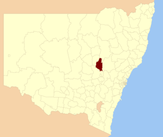
Cooma-Monaro Shire was a local government area located in the Monaro region of southern New South Wales, Australia. The area was named after the former Cooma Municipality and the former Monaro Shire, that were amalgamated to create it. The Municipality of Cooma was established in 1879, and the Monaro Shire was one of several shires established in 1906. The Monaro Shire and Cooma Municipal Council amalgamated in 1981. On 11 February 2004, Cooma-Monaro Shire absorbed a small part of the former Yarrowlumla Shire, near Michelago.

<span class="mw-page-title-main">Snowy River Shire</span> Former local government area in New South Wales, Australia

The Snowy River Shire was a local government area in the Australian Alps region of New South Wales, Australia from 1939 until May 2016. It was named after the Snowy River that runs through it. Prior to 1936, it had been named as Dalgety Shire since establishment in 1906.

<span class="mw-page-title-main">Wakool Shire</span> Former local government area in New South Wales, Australia

Wakool Shire was a local government area in the Riverina region of New South Wales, Australia. The Shire was located between the Murray River and the Murrumbidgee River and adjacent to the Sturt Highway. Towns in the Shire are Barham, Moulamein, Tooleybuc, Wakool and Koraleigh.

<span class="mw-page-title-main">Berrigan Shire</span> Local government area in New South Wales, Australia

Berrigan Shire is a local government area in the southern Riverina region of New South Wales, Australia. The Shire lies on the New South Wales State border with Victoria formed by the Murray River. The Shire is adjacent to the Newell and Riverina Highways. The Shire is a mainly agricultural region, with dairying, cattle raising, woolgrowing and cropping the main activities. The vast majority of the Shire is irrigated. Tourism is another major activity, concentrated on the river towns of Tocumwal and Barooga.

<span class="mw-page-title-main">Gloucester Shire</span> Former local government area in New South Wales, Australia

Gloucester Shire was a local government area in the Mid North Coast and Upper Hunter regions of New South Wales, Australia. The Shire was situated adjacent to the Bucketts Way and the North Coast railway line.

<span class="mw-page-title-main">Gundagai Shire</span> Former local government area in New South Wales, Australia

Gundagai Shire was a local government area in the Riverina region of New South Wales, Australia. On 12 May 2016, Gundagai Shire was abolished and merged with the neighbouring Cootamundra Shire to establish Cootamundra-Gundagai Regional Council.

<span class="mw-page-title-main">Bombala Shire</span> Former local government area in New South Wales, Australia

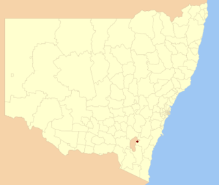
The Bombala Shire was a local government area in the Monaro region of south-eastern New South Wales, Australia. The Shire includes the town of Bombala, the villages of Delegate, Cathcart, Bibbenluke and the localities of Ando, Bungarby, Craigie, Mila, Rockton and Creewah. Bombala Shire was formed on 1 October 1977 by the amalgamation of the Municipality of Bombala and Bibbenluke Shire.

<span class="mw-page-title-main">Dungog Shire</span> Local government area in New South Wales, Australia

Dungog Shire is a local government area in the Hunter region of New South Wales, Australia. The Shire is situated adjacent to the Barrington Tops and consists predominantly of very rugged to hilly country which becomes less rugged from north to south.

<span class="mw-page-title-main">Young Shire</span> Former local government area in New South Wales, Australia

Young Shire was a local government area in the South West Slopes region of New South Wales, Australia. The Shire was located adjacent to the Olympic Highway.

<span class="mw-page-title-main">Harden Shire</span> Former local government area in New South Wales, Australia

Harden Shire was a local government area in the South West Slopes region of New South Wales, Australia. The Shire included the twin towns of Harden and Murrumburrah and the small towns of Galong, Jugiong, Wombat and Kingsvale.

<span class="mw-page-title-main">Tumut Shire</span> Former local government area in New South Wales, Australia

Tumut Shire was a local government area in the South West Slopes region of New South Wales, Australia.

<span class="mw-page-title-main">Tumbarumba Shire</span> Former local government area in New South Wales, Australia

Tumbarumba Shire was a local government area in the eastern Riverina region, located in the foothills of the Snowy Mountains, on the upper reaches of the Murray River in New South Wales, Australia. It came into existence in 1906. Prior to this the area covered by the shire was unincorporated. It included the town of Tumbarumba and the small towns of Rosewood, Tooma, Khancoban and Jingellic.

<span class="mw-page-title-main">Urana Shire</span> Former local government area in New South Wales, Australia

Urana Shire was a local government area in the Riverina region of New South Wales, Australia. The Newell Highway crosses its north-west corner. The Shire included the town of Urana and the small towns of Boree Creek, Morundah, Oaklands and Rand.

<span class="mw-page-title-main">Corowa Shire</span> Former local government area in New South Wales, Australia

Corowa Shire was a local government area in the Riverina region in southern New South Wales, Australia. The area was located adjacent to the Murray River and the Riverina Highway.

<span class="mw-page-title-main">Warren Shire</span> Local government area in New South Wales, Australia

Warren Shire is a local government area in the Orana region of New South Wales, Australia. The Shire is located adjacent to the Macquarie River and the Mitchell and Oxley Highways. The use of the area is mainly for wool and cotton growing.

<span class="mw-page-title-main">Edward River Council</span> Local government area in New South Wales, Australia

The Edward River Council is a local government area in the Murray region of New South Wales, Australia. This area was formed in 2016 from the merger of the Deniliquin Council with the surrounding Conargo Shire.

<span class="mw-page-title-main">Murray River Council</span> Local government area in New South Wales, Australia

The Murray River Council is a local government area in the Riverina region of New South Wales, Australia. This area was formed in 2016 from the merger of Murray Shire with Wakool Shire.

References

  1. "3218.0 – Regional Population Growth, Australia, 2012". Australian Bureau of Statistics. 30 August 2013. Retrieved 27 March 2014. Estimated resident population (ERP) at 30 June 2012.
  2. 1 2 3 4 "Councillors". Council. Murray Shire Council. September 2012. Retrieved 30 September 2012.
  3. "Merger proposal: Murray Shire Council, Wakool Shire Council" (PDF). Government of New South Wales. January 2016. p. 8. Retrieved 13 March 2016.
  4. "Murray River Council". Stronger Councils. Government of New South Wales. 12 May 2016. Retrieved 20 May 2016.
  5. 1 2 "Murray Shire Council: Summary of First Preference and Group Votes for each Candidate". Local Government Elections 2012. Electoral Commission of New South Wales. 13 September 2012. Retrieved 29 September 2012.