
Dubbo is a city in the Orana Region of New South Wales, Australia. It is the largest population centre in the Orana region, with a population of 43,516 at June 2021.

The City of Gosford was a local government area that was located in the Central Coast region in the state of New South Wales, Australia. The incorporation of Gosford dates back to 1886 when the Town of Gosford was proclaimed as the Borough of Gosford, becoming the Municipality of Gosford from 1906. In 1908, the Gosford Municipality merged into Erina Shire which covered the remaining Central Coast area outside of Gosford, but regained its independence in 1936. From 1 January 1947, local government in the Central Coast region was reorganised, creating Gosford Shire and Wyong Shire, and the final boundaries of Gosford City Council date from this period. From 1 January 1980, Gosford Shire was granted city status, becoming the City of Gosford. On 12 May 2016 the Minister for Local Government amalgamated the City of Gosford and Wyong Shire Councils. The Central Coast Council was established on the same day, covering the combined areas.

Wyong Shire was a local government area located in the Central Coast region of New South Wales, Australia. The incorporation of the Wyong area dates back to 7 March 1906 when the entire area of the Brisbane Water Police District outside of the Town of Gosford was proclaimed as the Erina Shire. From 1 January 1947, local government in the Central Coast region was reorganised, creating Gosford Shire and Wyong Shire, which comprised Erina Shire north and east of Kulnura, Central Mangrove and Lisarow.

The City of Willoughby is a local government area on the Lower North Shore of Northern Sydney, in the state of New South Wales, Australia. It is located 6 kilometres (3.7 mi) north of the Sydney central business district. It was first proclaimed in October 1865 as the Municipality of North Willoughby.

Blacktown City Council is a local government area in Western Sydney, situated on the Cumberland Plain, approximately 35 kilometres (22 mi) west of the Sydney central business district, in the state of New South Wales, Australia. Established in 1906 as the Blacktown Shire and becoming the Municipality of Blacktown in 1961 before gaining city status in 1979, the City occupies an area of 246.9 square kilometres (95.3 sq mi) and has a population of 366,534, making it the second most populous local government area in Sydney.

North Sydney Council is a local government area on the Lower North Shore of Sydney, New South Wales, Australia, established on 29 July 1890 through the amalgamation of three boroughs.

The City of Ryde is a local government area in the Northern Sydney region, in the state of New South Wales, Australia. It was first established as the Municipal District of Ryde in 1870, became a municipality in 1906 and was proclaimed as the City of Ryde in 1992.

Waverley Council is a Local government area in the eastern suburbs of Sydney, in the state of New South Wales, Australia. First incorporated on 16 June 1859 as the Municipality of Waverley, it is one of the oldest-surviving local government areas in New South Wales. Waverley is bounded by the Tasman Sea to the east, the Municipality of Woollahra to the north, and the City of Randwick in the south and west. The administrative centre of Waverley Council is located on Bondi Road in Bondi Junction in the Council Chambers on the corner of Waverley Park.

Leeton Shire is a local government area in the Riverina region of New South Wales, Australia. The Shire is located adjacent to the Murrumbidgee River and falls within the Murrumbidgee Irrigation Area.

Wollondilly Shire is a periurban local government area, located on the south west fringe of the Greater Sydney area in New South Wales, Australia, parts of which fall into the Macarthur, Blue Mountains and Central Tablelands regions in the state of New South Wales, Australia. Wollondilly is seen as the transition between Regional NSW and the Greater Sydney Region, and is variously categorised as part of both. Wollondilly Shire was created by proclamation in the NSW Government Gazette on 7 March 1906, following the passing of the Local Government (Shires) Act 1905, and amalgamated with the Municipality of Picton on 1 May 1940.

City of Wagga Wagga is a local government area in the Riverina region of southern New South Wales, Australia.
The City of Orange is a local government area in the Central West region of New South Wales, Australia. Based in Orange, the area is located adjacent to the Mitchell Highway and the Main Western railway line.

Muswellbrook Shire is a local government area in the Upper Hunter region of New South Wales, Australia. The Shire is situated adjacent to the New England Highway and the Hunter railway line.

Walcha Shire is a local government area located in the New England region of New South Wales, Australia. The Shire is situated adjacent to the junction of the Oxley Highway and Thunderbolts Way and is 20 kilometres (12 mi) east of the Main North railway line passing through Walcha Road. The shire was formed on 1 June 1955 through the amalgamation of Apsley Shire and the Municipality of Walcha.
Cumberland Council, trading as Cumberland City Council, is a local government area located in the western suburbs of Sydney in the state of New South Wales, Australia. The Council was formed on 12 May 2016 from the merger of parts of the Cities of Auburn, Parramatta, and Holroyd.

The City of Canterbury Bankstown is a local government area located in the South Western region of Sydney, New South Wales, Australia. The council was formed on 12 May 2016 from a merger of the City of Canterbury and the City of Bankstown, after a review of local government in New South Wales by the state government.

The Central Coast Council is a local government area in the Central Coast region of New South Wales, Australia. The area is adjacent to the Pacific Highway, Central Coast Highway and the Northern NSW railway line as well as the Pacific Ocean. It has over 40 beaches and over 90km of coastline. The Central Coast Council was formed on 12 May 2016 following the merger of the Gosford City and Wyong Shire councils.

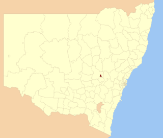
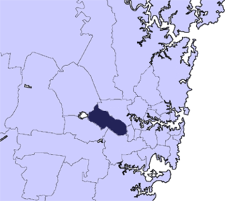
The Dubbo Regional Council is a local government area located in the Central West and Orana regions of New South Wales, Australia. The council was formed on 12 May 2016 through a merger of the City of Dubbo and Wellington Council as part of a widespread council amalgamation program. It was initially named Western Plains Regional Council for almost four months, and its name was changed to Dubbo Regional Council on 7 September 2016.
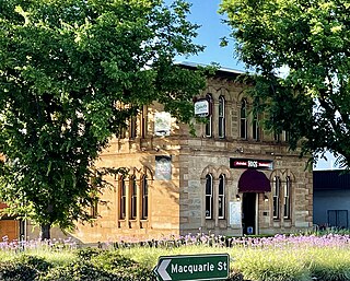
The Talbragar Shire Council Chambers is a heritage-listed former council chambers and former bank building located in Macquarie Street, Dubbo, in the Dubbo Regional Council local government area of New South Wales, Australia. The building was designed by Architect Hilley. It is also known as CBC Bank and Commercial Banking Company. The property is owned by Dubbo Regional Council and was added to the New South Wales State Heritage Register on 2 April 1999.

Scone Shire was a local government area in the Hunter region of New South Wales, Australia. The shire offices were located in the town of Scone.
