
The Communist Party of Australia (CPA), known as the Australian Communist Party (ACP) from 1944 to 1951, was an Australian communist party founded in 1920. The party existed until roughly 1991, with its membership and influence having been in a steady decline since its peak in 1945. Like most communist parties in the West, the party was heavily involved in the labour movement and the trade unions. Its membership, popularity and influence grew significantly during most of the interwar period before reaching its climax in 1945, where the party achieved a membership of slightly above 22,000 members. Although the party did not achieve a federal MP, Fred Paterson was elected to the Parliament of Queensland at the 1944 state election. He won re-election in 1947 before the seat was abolished. The party also held office in over a dozen local government areas across New South Wales and Queensland.
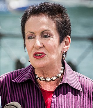
Clover Margaret Moore is an Australian politician. She has been the Lord Mayor of the City of Sydney since 2004 and is currently the longest serving Lord Mayor of Sydney since the creation of the City of Sydney in 1842. She was an independent member of the New South Wales Legislative Assembly from 1988 to 2012, representing the electorates of Bligh (1988–2007) and Sydney (2007–2012). Moore is the first popularly elected woman Lord Mayor of Sydney.
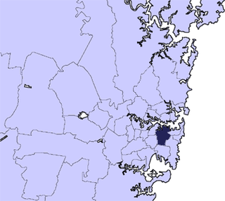
The City of Sydney is the local government area covering the Sydney central business district and surrounding inner city suburbs of the greater metropolitan area of Sydney, New South Wales, Australia. Established by Act of Parliament in 1842, the City of Sydney is the oldest, and the oldest-surviving, local government authority in New South Wales, and the second-oldest in Australia, with only the City of Adelaide being older by two years.

The Municipality of Ashfield was a local government area in the Inner West of Sydney, New South Wales, Australia. It is about 10 kilometres (6.2 mi) west of the Sydney central business district. The municipality was proclaimed on 28 December 1871 as the "Borough of Ashfield", which changed to the "Municipality of Ashfield" in 1906. On 12 May 2016, Ashfield merged with Marrickville Council and the Municipality of Leichhardt to form the Inner West Council.

Francesco Ernest Sartor is an Australian former politician who served as New South Wales Minister for Climate Change and the Environment and Minister Assisting the Minister for Health (Cancer) between 2009 and 2011. He was a Member of the New South Wales Legislative Assembly representing Rockdale for the Labor Party between 2003 and 2011. Sartor has previously been Minister for Planning, Redfern Waterloo and the Arts, and Minister for Water and Utilities in the Iemma and Carr governments. Before being elected to the New South Wales Parliament, Sartor was the second longest-serving Lord Mayor of Sydney, after Clover Moore, having held the post for nearly 12 years from September 1991 to March 2003. Sartor retired from politics at the 2011 state election.

The Sydney County Council (SCC) was formed in 1935 to produce electricity and operate the electricity network in a number of municipalities in metropolitan Sydney. Unlike other New South Wales county councils, which were voluntary associations of local councils to undertake local government activities permitted or required of them by the Local Government Act 1919, Sydney County Council was established under a separate piece of legislation by the state government to perform the electricity distribution and streetlighting operations of the local government areas concerned. On its establishment it assumed control of the Electricity Department of the Sydney City Council, which was already supplying electricity to other municipalities. In 1952, the SCC lost most its electricity generation functions to the Electricity Commission of New South Wales and retained only its distribution functions. The SCC was merged with other municipal county councils in 1990 to form Sydney Electricity.
Gordon Raymond "Mick" Ibbett was an Australian politician. He was a Labor member of the New South Wales Legislative Council from 1984 to 1991.
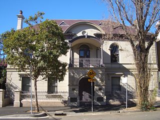
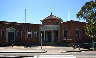
The Redfern Town Hall is a landmark sandstone civic building located in the heart of Redfern, New South Wales, Australia. built in 1870 and designed in the Victorian Regency style by George Allen Mansfield. It was the seat of the Municipality of Redfern from 1870 to 1948. It stands at 73 Pitt Street, Redfern.
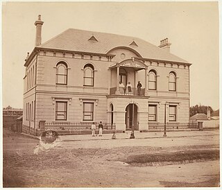
The Municipality of Redfern was a local government area of Sydney, New South Wales, Australia. The small municipality was proclaimed in 1859 as one of the first municipalities proclaimed under the new provisions of the Municipalities Act, 1858, and was centred on the suburbs of Redfern, Eveleigh, Darlington and Surry Hills. The council was amalgamated, along with most of its neighbours, with the City of Sydney to the north with the passing of the Local Government (Areas) Act 1948. From 1968 to 1982 and from 1989 to 2004, the area was part of the South Sydney councils.
John Henry Gardiner was an Australian politician, who served as a Member of the Legislative Council of New South Wales, Mayor of Redfern and Chairman of the Sydney County Council.
Thomas Douglas Percy Holden was an Australian politician who served as a Member of the New South Wales Legislative Council from 1912 to 1934 and also as an Alderman and Mayor of the Municipality of Redfern. The owner of a tobacconist and barber shop in Redfern, Holden spent most of his career associated with the Australian Labor Party.
The Erskineville Town Hall is a landmark civic building in Erskineville, a suburb of Sydney. It stands at 104 Erskineville Road. It was opened in 1938 in the Inter-war Mediterranean style by Lindsay Gordon Scott. The Town Hall was the seat of Erskineville Municipal Council from 1938 to 1948 and was the seat of the South Sydney Councils from 1968 to 1982 and 1989 to 2003. Since 2004 the town hall has been a community centre for the City of Sydney servicing the local area and is listed as a heritage item of local significance by the City of Sydney.
Cumberland Council, trading as Cumberland City Council, is a local government area located in the western suburbs of Sydney in the state of New South Wales, Australia. The Council was formed on 12 May 2016 from the merger of parts of the Cities of Auburn, Parramatta, and Holroyd.

Inner West Council is a local government area located in the Inner West region of Sydney in the state of New South Wales, Australia. The council makes up the eastern part of this wider region, and was formed on 12 May 2016 from the merger of the former Ashfield, Leichhardt and Marrickville councils.

The Municipality of Erskineville was a local government area of Sydney, New South Wales, Australia. The municipality was proclaimed as the "Municipal District of Macdonald Town" on 23 May 1872 and, with an area of 0.8 square kilometres, was one of the smallest local government areas in Sydney and included the modern suburb of Erskineville, part of Eveleigh and the locality of Macdonaldtown. The council was amalgamated, along with most of its neighbours, with the City of Sydney to the north with the passing of the Local Government (Areas) Act 1948. From 1968 to 1982 and from 1989 to 2004, the area was part of the South Sydney councils, with the former Town Hall serving as its council chambers.

The Municipality of Waterloo was a local government area of Sydney, New South Wales, Australia. The municipality was proclaimed on 16 May 1860 and, with an area of 3.4 square kilometres, included the modern suburbs of Waterloo, Zetland and Rosebery. The suburb of Alexandria was originally included as the Western Ward of the council but seceded as a separate municipality in 1868. After several attempts to amalgamate with various neighbours in the mid-1920s, the council was amalgamated with the City of Sydney, along with most of its neighbours, with the passing of the Local Government (Areas) Act 1948, although parts of the former council area were transferred in 1967 to the City of South Sydney.

Anthony Robert Pooley is an Australian public servant and former local government politician, who served from 2002 as the last Mayor of South Sydney before its amalgamation with the City of Sydney in 2004.

The 1948 Sydney City Council election was held on 4 December 1948 to elect councillors to the City of Sydney, a local government area of New South Wales, Australia.

The 2004 Sydney City Council election was held on 27 March 2004 to elect nine councillors and a lord mayor to the City of Sydney. The election was held as part of the statewide local government elections in New South Wales, Australia.
The 2000 New South Wales local elections were held from May to December 2000 elect the councils of local government areas (LGAs) of New South Wales, Australia. The elections were all scheduled to be held on 11 September 1999, but were deferred while possible amalgamations were considered.