Nambucca Shire

Last updated

Nambucca Valley Council
New South Wales
Nambucca LGA NSW.png
Location in New South Wales
Coordinates 30°43′S152°55′E / 30.717°S 152.917°E / -30.717; 152.917 Coordinates: 30°43′S152°55′E / 30.717°S 152.917°E / -30.717; 152.917
Population
 • Density12.885/km2 (33.373/sq mi)
Area1,491 km2 (575.7 sq mi)
MayorRhonda Hoban (Independent)
Council seat Macksville
Region Mid North Coast
State electorate(s) Oxley
Federal Division(s) Cowper
Nambucca Shire Council Logo.jpg
Website Nambucca Valley Council
LGAs around Nambucca Valley Council:
Armidale Bellingen Tasman Sea
Armidale Nambucca Valley Council Tasman Sea
Kempsey Kempsey Tasman Sea

Nambucca Valley council is a local government area in the mid north coast region of New South Wales, Australia.

Contents

The shire services an area of 1,491 square kilometres (576 sq mi) and is located adjacent to the Pacific Highway and the North Coast railway line. At the 2011 census, Nambucca Valley Council had a high proportion of Aboriginal and Torres Strait Islander people residing within its boundaries; being 7.3 per cent of the population, nearly treble the national and state averages of 2.5 per cent. [3] Within the Shire's boundaries is Bowraville, one of the most socially disadvantaged areas in Australia. [4]

The Mayor of the Nambucca Valley Council is Rhonda Hoban, an independent politician. [5]

Towns and localities

Towns and localities in the Nambucca Valley Council area:

Heritage listings

The Nambucca Valley has a number of heritage-listed sites, including:

Demographics

Nambucca Heads aerial panorama Nambucca Heads aerial panorama.jpg
Nambucca Heads aerial panorama

At the 2011 census, there were 18,644 people in the Nambucca Valley local government area, of these 48.8 per cent were male and 51.2 per cent were female. Aboriginal and Torres Strait Islander people made up 7.3 per cent of the population, nearly treble the national and state averages of 2.5 per cent. The median age of people in the Nambucca Valley Council was 49 years; some twelve years higher than the national median. Children aged 0 – 14 years made up 17.8 per cent of the population and people aged 65 years and over made up 24.4 per cent of the population. Of people in the area aged 15 years and over, 46.6 per cent were married and 16.4 per cent were either divorced or separated. [3]

Population growth in the Nambucca Valley Council between the 2001 census and the 2006 census was 1.34 per cent; and in the subsequent five years to the 2011 census was 4.17 per cent. When compared with total population growth of Australia for the same periods, being 5.78 per cent and 8.32 per cent respectively, population growth in the Nambucca Valley Council local government area was significantly lower than the national average. [7] The median weekly income for residents within the Nambucca Valley Council was significantly below the national average, [3] [8] being one of the factors that place parts of the Nambucca Valley Council in an area of social disadvantage. [4]

At the 2011 Census, the proportion of residents in the Nambucca Valley Council local government area who stated their ancestry as Australian or Anglo-Saxon exceeded 82 per cent of all residents (national average was 65.2 per cent). In excess of 58 per cent of all residents in the Nambucca Valley Council nominated a religious affiliation with Christianity at the 2011 census, which was slightly higher than the national average of 50.2 per cent. Meanwhile, as at the census date, compared to the national average, households in the Nambucca Valley Council local government area had a significantly lower than average proportion (3.5 per cent) where two or more languages are spoken (national average was 20.4 per cent); and a significantly higher proportion (93.8 per cent) where English only was spoken at home (national average was 76.8 per cent). Of the 60 Australian residents who stated that they speak Gumbaynggir, an Australian Aboriginal language, over half live within the Nambucca Valley Council. [3]

Selected historical census data for Nambucca local government area
Census year2001 [7] 2006 [8] 2011 [3] 2016 [1]
PopulationEstimated residents on census night 17,66017,89718,64419,212
LGA rank in terms of size within New South Wales 71st
% of New South Wales population0.27%
% of Australian population0.09%Steady2.svg 0.09%Steady2.svg 0.09%
Cultural and language diversity
Ancestry,
top responses
Australian 33.4%
English 32.6%
Irish 8.7%
Scottish 7.9%
German 3.0%
Language,
top responses
(other than English)
German 0.3%Steady2.svg 0.3%Decrease2.svg 0.2%
Gumbaynggir n/cIncrease2.svg 0.1%Increase2.svg 0.2%
French 0.1%Steady2.svg 0.1%Increase2.svg 0.2%
Dutch 0.2%Decrease2.svg 0.1%Increase2.svg 0.2%
Italian 0.2%Decrease2.svg 0.1%Steady2.svg 0.1%
Religious affiliation
Religious affiliation,
top responses
Anglican 30.3%Decrease2.svg 28.1%Decrease2.svg 25.7%
Catholic 22.1%Decrease2.svg 21.4%Increase2.svg 21.8%
No Religion 13.5%Increase2.svg 17.8%Increase2.svg 21.2%
Presbyterian and Reformed 6.2%Decrease2.svg 5.8%Decrease2.svg 5.5%
Uniting Church 6.8%Decrease2.svg 6.4%Decrease2.svg 5.3%
Median weekly incomes
Personal incomeMedian weekly personal incomeA$296A$377
% of Australian median income63.5%Increase2.svg 65.3%
Family incomeMedian weekly family incomeA$562A$853
% of Australian median income54.7%Increase2.svg 57.6%
Household income Median weekly household incomeA$642A$700
% of Australian median income54.8%Increase2.svg 56.7%

Council

Current composition and election method

Nambucca Valley Council is composed of nine Councillors, including the Mayor, for a fixed four-year term of office. The Mayor is directly elected while the eight other Councillors are elected proportionally as one entire ward. The most recent election was held on 10 September 2016, and the makeup of the Council is as follows: [5] [9]

PartyCouncillors
  Independents and Unaffiliated8
  Country Labor 1
Total9

The current Council, elected in 2016, in order of election, is: [9]

CouncillorPartyNotes
 Rhonda Hoban Independent Mayor [5]
 John AinsworthUnaligned
 Susan Jenvey Country Labor
 Martin Ballangarry Independent
 Brian FinlaysonUnaligned
 Anne Smyth Independent
 Janine ReedUnaligned
 John Wilson Independent
 David Jones Independent

See also

Related Research Articles

Clarence Valley Council Local government area in New South Wales, Australia

Clarence Valley Council is a local government area in the Northern Rivers region of New South Wales, Australia.

Liverpool Plains Shire Local government area in New South Wales, Australia

Liverpool Plains Shire is a local government area located in the North West Slopes region of New South Wales, Australia. The Shire was formed on 17 March 2004 by the amalgamation of Quirindi Shire with parts of Parry, Murrurundi and Gunnedah shires.

City of Cessnock Local government area in New South Wales, Australia

City of Cessnock is a local government area in the Hunter region of New South Wales, Australia. The area under administration is located to the west of Newcastle. The largest population centre and council seat is the city of Cessnock.

Richmond Valley Council (RVC) is a local government area on the Northern Rivers region of north-eastern New South Wales, Australia. RVC services an area of 3,051 square kilometres (1,178 sq mi) and draws its name from the Richmond River, which flows through most of the council area. The area under management is located adjacent to the Bruxner Highway, Pacific Highway, and the North Coast railway line.

Camden Council (New South Wales) Local government area in New South Wales, Australia

Camden Council is a local government area in the Macarthur region of Sydney, in the state of New South Wales, Australia. The area is located south west of the Sydney central business district and comprises 201 square kilometres (78 sq mi) with an estimated population at the 2016 census of 78,218. The Mayor of Camden is Cr. Theresa Fedeli, a member of the Liberal Party.

City of Liverpool (New South Wales) Local government area in New South Wales, Australia

The Liverpool City Council is a local government area to the south-west of Sydney, in the state of New South Wales, Australia. The area encompasses 305.5 square kilometres (118.0 sq mi) and its administrative centre is located in the suburb of Liverpool.

Tweed Shire Local government area in New South Wales, Australia

Tweed Shire is a local government area located in the Northern Rivers region of New South Wales, Australia. The shire is located adjacent to the border with Queensland where it meets the Tasman Sea coast. The shire, administered from the town of Murwillumbah, covers an area of 1,321.0 square kilometres (510.0 sq mi), and has existed as a local government entity since 1947. It was named for the Tweed River.

Gloucester Shire Local government area in New South Wales, Australia

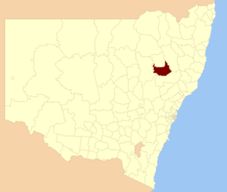
Gloucester Shire was a local government area in the Mid North Coast and Upper Hunter regions of New South Wales, Australia. The Shire was situated adjacent to the Bucketts Way and the North Coast railway line.

Kyogle Council Local government area in New South Wales, Australia

Kyogle Council is a local government area in the Northern Rivers region of New South Wales, Australia.

Ballina Shire Local government area in New South Wales, Australia

Ballina Shire is a local government area in the Northern Rivers region of New South Wales, Australia. The Shire was formed in 1976 by the amalgamation of the Municipality of Ballina and Tintenbar Shire. The Shire is located adjacent to the Tasman Sea and the Pacific Highway. The Council seat is located in the town of Ballina.

Bellingen Shire Local government area in New South Wales, Australia

Bellingen Shire is a local government area in the mid north coast region of New South Wales, Australia. The Shire is located adjacent to the Pacific Highway, Waterfall Way and the North Coast railway line.

City of Coffs Harbour Local government area in New South Wales, Australia

The City of Coffs Harbour is a local government area in the mid north coast region of New South Wales, Australia. The area under administration is 1,175 square kilometres (454 sq mi), expanded in 2004 to take in parts of the former Pristine Waters local government area.

City of Lismore Local government area in New South Wales, Australia

The City of Lismore is a local government area in the Northern Rivers region of New South Wales, Australia. The seat of the local government area is Lismore, a major regional centre of the state.

Kempsey Shire Local government area in New South Wales, Australia

Kempsey Shire is a local government area in the mid north coast region of New South Wales, Australia.

Singleton Council Local government area in New South Wales, Australia

Singleton Council is a local government area in the Hunter Region of New South Wales, Australia. It is situated adjacent to the New England Highway and the Hunter railway line.

Muswellbrook Shire Local government area in New South Wales, Australia

Muswellbrook Shire is a local government area in the Upper Hunter region of New South Wales, Australia. The Shire is situated adjacent to the New England Highway and the Hunter railway line.

Glen Innes Severn Local government area in New South Wales, Australia

Glen Innes Severn is a local government area in the New England region of New South Wales, Australia. The council serves an area of 5,487 square kilometres (2,119 sq mi) and is located adjacent to the New England Highway. The council was formed by the amalgamation of Severn Shire and Glen Innes City Council.

Tenterfield Shire Local government area in New South Wales, Australia

Tenterfield Shire is a local government area located in the New England region of New South Wales, Australia. The Shire is situated adjacent to the New England Highway.

Inverell Shire Local government area in New South Wales, Australia

Inverell Shire is a local government area in the North West Slopes region of New South Wales, Australia adjacent to the Macintyre River and the Gwydir Highway.

Dungog Shire Local government area in New South Wales, Australia

Dungog Shire is a local government area in the Hunter region of New South Wales, Australia. The Shire is situated adjacent to the Barrington Tops and consists predominantly of very rugged to hilly country which becomes less rugged from north to south.

References

  1. 1 2 Australian Bureau of Statistics (27 June 2017). "Nambucca (A)". 2016 Census QuickStats. Retrieved 7 July 2017. OOjs UI icon edit-ltr-progressive.svg
  2. "3218.0 – Regional Population Growth, Australia, 2017-18". Australian Bureau of Statistics. 27 March 2019. Retrieved 27 March 2019. Estimated resident population (ERP) at 30 June 2018.
  3. 1 2 3 4 5 Australian Bureau of Statistics (31 October 2012). "Nambucca (A)". 2011 Census QuickStats. Retrieved 1 December 2012. OOjs UI icon edit-ltr-progressive.svg
  4. 1 2 Horin, Adele (26 February 2007). "Economic boom bypasses nation's poor". The Sydney Morning Herald . Retrieved 1 December 2012.
  5. 1 2 3 "Nambucca Valley Council - Mayoral Election". Local Government Election 2016. Electoral Commission of New South Wales. 19 September 2016. Retrieved 6 October 2016.
  6. "Macksville Railway Station group". New South Wales State Heritage Register . Office of Environment and Heritage. H01184. Retrieved 18 May 2018.
  7. 1 2 Australian Bureau of Statistics (9 March 2006). "Nambucca (A)". 2001 Census QuickStats. Retrieved 1 December 2012.
  8. 1 2 Australian Bureau of Statistics (25 October 2007). "Nambucca (A)". 2006 Census QuickStats. Retrieved 1 December 2012.
  9. 1 2 "Nambucca Valley Council - Summary of First Preference Votes for each Candidate". Local Government Election 2016. Electoral Commission of New South Wales. 19 September 2016. Retrieved 6 November 2016.