17 June 1961 (Municipality)
9 March 1979 (City)"},"seat":{"wt":"Civic Centre, [[Blacktown, New South Wales|Blacktown]]"},"mayor":{"wt":"Tony Bleasdale"},"region":{"wt":"[[Western Sydney]]"},"logo":{"wt":"Blacktown City Council Logo.png"},"logo_upright":{"wt":"1.2"},"url":{"wt":"http://www.blacktown.nsw.gov.au"},"stategov":{"wt":"[[Electoral district of Blacktown|Blacktown]]"},"stategov2":{"wt":"[[Electoral district of Seven Hills|Seven Hills]]"},"stategov3":{"wt":"[[Electoral district of Mount Druitt|Mount Druitt]], [[Electoral district of Riverstone|Riverstone]]"},"stategov4":{"wt":"[[Electoral district of Londonderry|Londonderry]], [[Electoral district of Prospect|Prospect]]"},"fedgov":{"wt":"[[Division of Chifley|Chifley]]"},"fedgov2":{"wt":"[[Division of Greenway|Greenway]]"},"fedgov3":{"wt":"[[Division of McMahon|McMahon]]"},"near-nw":{"wt":"[[City of Penrith|Penrith]]"},"near-n":{"wt":"[[City of Hawkesbury|Hawkesbury]]"},"near-ne":{"wt":"[[The Hills Shire]]"},"near-e":{"wt":"[[City of Parramatta Council|Parramatta]]"},"near-w":{"wt":"[[City of Penrith|Penrith]]"},"near-sw":{"wt":"[[City of Penrith|Penrith]]"},"near-s":{"wt":"[[City of Fairfield|Fairfield]]"},"near-se":{"wt":"[[Cumberland Council, New South Wales|Cumberland]]"}},"i":0}}]}" id="mwCQ">Local government area in New South Wales, Australia
Blacktown City Council New South Wales | |||||||||||||||
---|---|---|---|---|---|---|---|---|---|---|---|---|---|---|---|
![]() Location in Metropolitan Sydney | |||||||||||||||
Coordinates | 33°46′S150°55′E / 33.767°S 150.917°E Coordinates: 33°46′S150°55′E / 33.767°S 150.917°E | ||||||||||||||
Population |
| ||||||||||||||
• Density | |||||||||||||||
Established | 6 March 1906 (Shire) 17 June 1961 (Municipality) 9 March 1979 (City) | ||||||||||||||
Area | 246.9 km2 (95.3 sq mi) | ||||||||||||||
Time zone | AEST (UTC+10) | ||||||||||||||
• Summer (DST) | AEDT (UTC+11) | ||||||||||||||
Mayor | Tony Bleasdale | ||||||||||||||
Council seat | Civic Centre, Blacktown | ||||||||||||||
Region | Western Sydney | ||||||||||||||
State electorate(s) | |||||||||||||||
Federal Division(s) | |||||||||||||||
![]() | |||||||||||||||
Website | Blacktown City Council | ||||||||||||||
|
Blacktown City Council is a local government area in Western Sydney, situated on the Cumberland Plain, approximately 35 kilometres (22 mi) west of the Sydney central business district, in the state of New South Wales, Australia. Established in 1906 as the Blacktown Shire and becoming the Municipality of Blacktown in 1961 before gaining city status in 1979, the City occupies an area of 246.9 square kilometres (95.3 sq mi) and has a population of 366,534, making it the second most populous local government area in Sydney. [3]
The Mayor of the Blacktown City Council is Cr. Tony Bleasdale OAM, a member of the Australian Labor Party, who was elected on 9 October 2019 following the resignation of Stephen Bali.
The first road from Prospect to Richmond became known as the "Black Town Road" and in 1860 the Railway Department gave the name of "Black Town Road Station" to the railway station at the junction of the railway and the Black Town Road, with the name shortening to "Blacktown" by 1862. The Blacktown area was first incorporated on 6 March 1906 as the "Shire of Blacktown" alongside 132 other new shires across the state as a result of the passing of the Local Government (Shires) Act, 1905. [4] The first five-member temporary council was appointed on 15 May 1906 and first met on 20 June in the Rooty Hill School of Arts. [5] [6] [7] [8] The Blacktown Shire became the "Municipality of Blacktown" on 17 June 1961 and was granted city status on 9 March 1979, becoming the "City of Blacktown". [9] [10] [11]
The City of Blacktown has a number of heritage-listed sites, including those on the New South Wales State Heritage Register:
These are the suburbs and localities in the local government area:
At the 2016 census, there were 336,962 people resident in the Blacktown local government area, of these 49.7 per cent were male and 50.3 per cent were female. Aboriginal and Torres Strait Islander people made up 2.8 per cent of the population, which was slightly higher than the NSW and Australian averages of 2.9 and 2.8 per cent respectively. The median age of people in the City of Blacktown was 33 years, which was significantly lower than the national median of 38 years. Children aged 0 – 14 years made up 22.8 per cent of the population and people aged 65 years and over made up 9.0%10.3 per cent of the population. Of people in the area aged 15 years and over, 52.3 per cent were married and 9.9 per cent were either divorced or separated. [1]
Population growth in the City of Blacktown between the 2001 census and the 2006 census was 6.47 per cent; and in the subsequent five years to the 2011 census, population growth was 10.82 per cent. At the 2016 census, the population in the local government area increased by 11.91 per cent. When compared with total population growth of Australia for the same period, being 8.8 per cent, population growth in Blacktown local government area was in excess of 35% more than the national average. [20] The median weekly income for residents within the City of Blacktown was generally on par with the national average. [21] [22]
At the 2016 census, the proportion of residents in the Blacktown local government area who stated their ancestry as Filipino, was in excess of six times the national average. The proportion of residents who stated a religious affiliation with Hinduism was in excess of three times the national average; the proportion of Catholics was 33 per cent above the national average; and the proportion of residents with no religion about half the national average. Meanwhile, as at the census date, the area was linguistically diverse, with Tagalog, Hindi, Punjabi, or Filipino languages spoken in households, and ranged from five times to eight times the national averages. Pacific Island languages such as Samoan and Tongan were also noticeable in the area. [1]
Selected historical census data for Blacktown local government area | ||||||
---|---|---|---|---|---|---|
Census year | 2001 [23] | 2006 [22] | 2011 [21] | 2016 [1] | ||
Population | Estimated residents on census night | 255,195 | ![]() | ![]() | ![]() | |
LGA rank in terms of size within New South Wales | 1st | ![]() | ||||
% of New South Wales population | 3.88% | ![]() | ![]() | ![]() | ||
% of Australian population | 1.36% | ![]() | ![]() | ![]() | ||
Cultural and language diversity | ||||||
Ancestry, top responses | Australian | 30.0% | ![]() | ![]() | ![]() | |
English | 24.8% | ![]() | ![]() | ![]() | ||
Indian | 3.7% | ![]() | ![]() | ![]() | ||
Filipino | 6.7% | ![]() | ![]() | ![]() | ||
Irish | 6.7% | ![]() | ![]() | ![]() | ||
Language, top responses (other than English) | Tagalog | 5.1% | ![]() | ![]() | ![]() | |
Hindi | 1.8% | ![]() | ![]() | ![]() | ||
Punjabi | 0.8% | ![]() | ![]() | ![]() | ||
Arabic | 2.9% | ![]() | ![]() | ![]() | ||
Filipino | n/c | ![]() | ![]() | ![]() | ||
Religious affiliation | ||||||
Religious affiliation, top responses | Catholic | 36.3% | ![]() | ![]() | ![]() | |
No religion, so described | 8.4% | ![]() | ![]() | ![]() | ||
Anglican | 19.6% | ![]() | ![]() | ![]() | ||
Hinduism | 2.3% | ![]() | ![]() | ![]() | ||
Not stated | 7.6% | |||||
Median weekly incomes | ||||||
Personal income | Median weekly personal income | A$473 | ![]() | A$672 | ||
% of Australian median income | 101.5% | ![]() | 101.5% | |||
Family income | Median weekly family income | A$1,105 | ![]() | A$1,817 | ||
% of Australian median income | 107.6% | ![]() | 104.8% | |||
Household income | Median weekly household income | A$1,188 | ![]() | A$1,711 | ||
% of Australian median income | 101.5% | ![]() | 119% | |||
Blacktown City Council is composed of fifteen Councillors elected proportionally as five separate wards, each electing three Councillors. All Councillors are elected for a fixed four-year term of office. The Mayor is elected by the Councillors at the first meeting of the Council and since 2016 has served a two-year term. The Mayor from 2014 to 2019, Stephen Bali was required to stand down from Council as a Mayor and Councillor by October 2019, due to the Local Government Amendment (Members of Parliament) Act, 2012 which requires state members of parliament to relinquish local government offices no more than two years after their election. With Bali's resignation on 9 October 2019, Cr Tony Bleasdale was elected Mayor. [25]
The most recent election was held on 10 September 2016, and the makeup of the Council is as follows: [26] [27] [28] [29] [30]
Party | Councillors | |
---|---|---|
Australian Labor Party | 9 | |
Liberal Party of Australia | 5 | |
Vacant | 1 | |
Total | 15 |
The current Council, elected in 2016, in order of election by ward, is:
Ward | Councillor | Party | Notes | |
---|---|---|---|---|
Ward 1 [26] | Chris Quikley | Labor | ||
Jess Diaz | Liberal | |||
Moninder Singh | Labor | |||
Ward 2 [27] | Kevin Gilles | Labor | ||
Jaymes Diaz | Liberal | [31] | ||
Julie Griffiths | Labor | Deputy Mayor 2019–date | ||
Ward 3 [28] | Susai Benjamin | Labor | ||
Kathie Collins OAM | Labor | |||
Frederick Brillo | Liberal | |||
Ward 4 [29] | Vacant | Stephen Bali resigned 9 October 2019. No by-election to be held. | ||
Carol Israel | Labor | |||
Linda Santos | Liberal | |||
Ward 5 [30] | Tony Bleasdale OAM | Labor | Mayor 2019–date | |
Brad Bunting | Labor | |||
Peter Camilleri | Liberal |
Shire President | Party | Term | Notes | |
---|---|---|---|---|
Richard Joseph Sherlock (Chairman) | Independent | 20 June 1906 – 10 December 1906 | [32] | |
Thomas Willmot | Independent | 10 December 1906 – 2 February 1910 | [33] [34] [35] [36] [37] | |
Richard Joseph Sherlock | Independent | 2 February 1910 – 9 February 1911 | [38] [39] [40] | |
Thomas Willmot | Independent | 9 February 1911 – 4 February 1914 | [41] [42] [43] | |
George Best | Independent | 4 February 1914 – 1 March 1915 | [44] | |
Adam Thomson Pringle | Independent | 1 March 1915 – 9 February 1916 | [45] | |
John Henry Smith Angus | Independent | 9 February 1916 – 10 February 1920 | [46] [47] [48] [49] | |
John Charles Page | Independent | 10 February 1920 – 14 December 1920 | [50] | |
George Alfred Lalor | Independent | 14 December 1920 – 12 December 1922 | [51] [52] | |
Arthur Moorehead | Independent | 12 December 1922 – 21 December 1926 | [53] [54] [55] [56] [57] | |
William Thomas Cable | Independent | 21 December 1926 – December 1927 | [58] | |
George Alfred Lalor | Independent | December 1927 – December 1928 | ||
Arthur Leonard Francis | Independent | December 1928 – December 1930 | ||
John McMurtrie | Independent | December 1930 – December 1932 | ||
John Charles Page | Independent | December 1932 – December 1934 | ||
Arthur Leonard Francis | Independent | December 1934 – 8 December 1938 | ||
Thomas Russell Stone | Independent | 8 December 1938 – 13 December 1945 | [59] [60] [61] [62] [63] [64] [65] | |
John Alexander Fyall | Independent | 13 December 1945 – 20 December 1950 | [66] [67] [68] [69] [70] | |
John Sidney Bromfield | 20 December 1950 – December 1956 | [71] | ||
Wally Payne | December 1956 – December 1957 | |||
George Alexander Dryden | December 1957 – December 1958 | [72] | ||
Gordon Archibald Baker | December 1958 – December 1959 | |||
Alfred Ashley-Brown | Labor | December 1959 – 17 June 1961 | ||
Mayor | Party | Term | Notes | |
Alfred Ashley-Brown | Labor | 17 June 1961 – December 1965 | ||
Victor John Corcoran | December 1965 – December 1966 | |||
Hilton Robinson | Independent | December 1966 – December 1967 | ||
Alfred Ashley-Brown | Labor | December 1967 – December 1968 | ||
Victor John Corcoran | December 1968 – 10 December 1969 | |||
Col Holden | 10 December 1969 – 2 December 1970 | |||
Alfred Ashley-Brown | Labor | 2 December 1970 – September 1971 | ||
Peter Richard Stone | September 1971 – September 1974 | |||
George Nicolaidis OAM | Independent | September 1974 – September 1976 | [73] [74] [75] | |
Peter James Shinnick | September 1976 – September 1977 | |||
John Aquilina | Labor | September 1977 – September 1981 | [76] | |
James Patrick Lynch | September 1981 – September 1985 | |||
Leo Kelly | September 1985 – September 1987 | [77] | ||
Russ Dickens OAM | Independent | September 1987 – September 1988 | [78] [79] | |
Bob Sinclair | Independent | September 1988 – September 1990 | ||
Leo Kelly | Labor | September 1990 – September 1991 | [77] | |
Jim Anderson | September 1991 – 5 April 1995 | [80] | ||
Charlie Lowles | 5 April 1995 – 20 September 1995 | [81] | ||
Michael Corbin | 20 September 1995 – September 1996 | |||
Charlie Lowles | September 1996 – September 1999 | [81] | ||
Alan Pendleton | September 1999 – 14 April 2004 | [82] | ||
Leo Kelly OAM | 14 April 2004 – September 2008 | [83] [77] | ||
Charlie Lowles OAM | September 2008 – September 2010 | [81] [84] | ||
Alan Pendleton OAM | September 2010 – 26 September 2012 | [82] | ||
Len Robinson | Liberal | 26 September 2012 – 17 September 2014 | [85] [86] | |
Stephen Bali | Labor | 17 September 2014 – 9 October 2019 | [87] | |
Tony Bleasdale OAM | 9 October 2019 – date | [25] |
Name | Term | Notes |
---|---|---|
Matthew W. Hawkings (Interim) | 20 June 1906 – 31 December 1906 | [88] |
Hugh Reid | 1 January 1907 – 1 February 1914 | [89] [90] |
George Davis | 1 February 1914 – March 1916 | [91] |
Eric H. Croxon | 28 March 1916 – May 1920 | [92] |
T. B. Webster | 24 May 1920 – 30 May 1922 | [93] |
George Nixon Stewart | 30 May 1922 – 12 September 1943 | [94] [95] [96] |
Herbert K. Pollack | 29 May 1944 – 1959 | [97] |
W. A. C. Dale | 1959–1969 | [88] |
Max Webber | 1969–1984 | [88] |
Dennis G. Johnson | 1984–1996 | [88] |
Terry McCormack | 1996–2000 | [88] |
Ian Reynolds | 2000–2005 | [88] |
Ron Moore | 2005 – 17 April 2013 | [98] |
Kerry Robinson | July 2013 – present |
After becoming a city in 1979, the Council resolved to investigate and if possible obtain a coat of arms, making a request to the Chester Herald of Arms, Hubert Chesshyre. With the design completed by March 1981, Council resolved to adopt the Coat of Arms at its meeting on 1 April 1981. [99] [100]
![]() |
|
Blacktown City Council has sister city relations with the following cities: [101]
Carlingford railway station was a railway station in Sydney, Australia. It opened in 1896 and was the terminus of the Carlingford line, which served the suburb of Carlingford and was served by Sydney Trains T6 Carlingford line services. The Carlingford railway line was closed on 5 January 2020 with the station demolished in May 2020
The City of Holroyd was a local government area in the western suburbs of Sydney, in the state of New South Wales, Australia. First proclaimed in July 1872 as the "Municipal District of Prospect and Sherwood", it became the "Municipality of Prospect and Sherwood" from 1906 and in 1927 it was renamed the "Municipality of Holroyd" after Arthur Holroyd, the first mayor. From 1 January 1991, city status was granted, becoming the Holroyd City Council. The administrative centre of the City was located in the suburb of Merrylands, located approximately 25 kilometres (16 mi) west of the Sydney central business district.
The Auburn City Council was a local government area in the Greater Western Sydney region of New South Wales, Australia. Prior to its 2016 merger, the council area was located about 15 kilometres (9.3 mi) west of the Sydney central business district and had a culturally diverse population. Notable features in the area included the Gallipoli Mosque, located in the suburb of Auburn. The suburb of Sydney Olympic Park, the site of the main venues of the 2000 Summer Olympics, was located in the council area.
The City of Fairfield is a local government area in the west of Sydney, in the state of New South Wales, Australia. The council was first incorporated as the "Municipal District of Smithfield and Fairfield" on 8 December 1888, and the council's name was changed to the "Municipality of Fairfield" in 1920, before being proclaimed a city in 1979. The City of Fairfield comprises an area of 102 square kilometres (39 sq mi) and as of the 2016 census had a population of 198,817. The Mayor of the City of Fairfield is Cr. Frank Carbone, the first popularly-elected independent mayor of Fairfield.
The City of Penrith is a local government area in the state of New South Wales, Australia. The seat of the city is located in Penrith, located about 50 kilometres (31 mi) west of Sydney's central business district. It occupies part of the traditional lands of the Darug people. First incorporated as a municipality on 12 May 1871, on 1 January 1949, the municipalities of Penrith, St Marys and Castlereagh and part of the Nepean Shire amalgamated to form a new Municipality of Penrith. Penrith was declared a City on 21 October 1959, and expanded westwards to include Emu Plains and Emu Heights, formerly part of the City of Blue Mountains, on 25 October 1963. As at the 2016 census the City of Penrith had an estimated population of 196,066.
The City of Ryde is a local government area that services certain suburbs located within the Northern Sydney region, in the state of New South Wales, Australia. It was first established as the Municipal District of Ryde in 1870, became a municipality in 1906 and was proclaimed as the City of Ryde in 1992.
William John Long was an Australian politician.
William Henry Lamb was an Australian politician. He was a member of the New South Wales Legislative Assembly from 1938 until 1962 and a member of the NSW Branch of the Labor Party and the Lang Labor Party. He was the Speaker of the New South Wales Legislative Assembly between 1947 and 1959.
The Cumberland Argus and Fruitgrowers’ Advocate was a newspaper published in Parramatta with coverage and circulation incorporating Greater Western Sydney and parts of North-West Sydney, Australia. First published on 24 September 1887, the paper continued under this title until issue No. 3397, on 15 March 1950, when the newspaper was officially renamed the Cumberland Argus. It remained under this banner for a further 12 years until it ceased publication on 24 October 1962.
The Nepean Times was a weekly newspaper first published in the Australian city of Penrith, New South Wales on 3 March 1882.
Lord Livingstone "Livie" Ramsay was an Australian architect active in the first quarter of the 20th century. He was known professionally as L L Ramsay. His work encompassed the styles of the Federation Bungalow in domestic design and Federation Free Classical in civic and commercial design. He was active in local government and was President of Hornsby Shire.
The Cumberland Free Press was a short-lived weekly Australian newspaper published and printed in Parramatta, New South Wales, with a coverage extending across the Inner West, Western and North West regions of Sydney. The paper was first published on 22 June 1895 and ceased publication in March 1898.
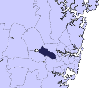
The Cumberland City Council is a local government area located in the western suburbs of Sydney in the state of New South Wales, Australia. The Council was formed on 12 May 2016 from the merger of parts of the Cities of Auburn, Parramatta, and Holroyd.
The Weekly Advance was an English-language tabloid newspaper published in Granville, New South Wales, Australia, between 1892 and 1894. The paper principally covered the townships of Granville, Auburn, and Rookwood, with circulation and content extending to Clyde. Flemington, Homebush, Strathfield, Bankstown, Mortlake, Newington, Merrylands, Guildford, Smithfield and Fairfield.
The Municipality of Lidcombe was a local government area in the Western region of Sydney, New South Wales, Australia. The municipality was proclaimed as the Borough of Rookwood on 8 December 1891 and was renamed to the Municipality of Lidcombe, a portmanteau of two mayor's names, in order to differentiate itself from the expanding necropolis, from 15 October 1913. It included the modern suburbs of Rookwood, Lidcombe, Homebush Bay, Berala and parts of Newington, Silverwater, Homebush West and Regents Park. From 1 January 1949, the council was amalgamated into the Municipality of Auburn, with the passing of the Local Government (Areas) Act 1948.
The Municipality of Granville was a local government area in the Western region of Sydney, New South Wales, Australia. The municipality was proclaimed as the Borough of Granville on 20 January 1885. It included the modern suburbs of Granville, South Granville, Camellia, Rosehill, Clyde and parts of Harris Park, Guildford and Merrylands. From 1 January 1949, the council was amalgamated into the City of Parramatta, with the passing of the Local Government (Areas) Act 1948.
The Municipality of Ermington and Rydalmere was a local government area in the Western region of Sydney, New South Wales, Australia. Initially proclaimed as the southern part of the Borough of Dundas in 1889, following a petition of secession the municipality was proclaimed as the Municipal District of Ermington and Rydalmere on 18 June 1891. It included the modern suburbs of Rydalmere and parts of Dundas, Ermington and Melrose Park. From 1 January 1949, the council was amalgamated into the City of Parramatta, with the passing of the Local Government (Areas) Act 1948.
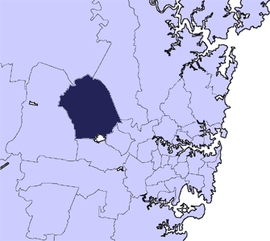
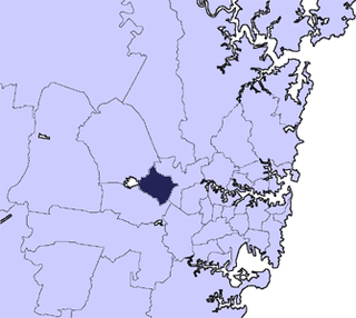
The Municipality of Dundas was a local government area in the North-western region of Sydney, New South Wales, Australia. Initially proclaimed as the "Borough of Dundas" on 23 March 1889, the southern part of the municipality seceded in June 1891 as the Municipal District of Ermington and Rydalmere. From 1891, the municipality included the modern suburbs of Dundas, Dundas Valley and parts of Ermington, Epping, Eastwood, Melrose Park, Oatlands and Carlingford. From 1 January 1949, the council was amalgamated into the City of Parramatta, with the passing of the Local Government (Areas) Act 1948.
Scone Shire was a local government area in the Hunter region of New South Wales, Australia. The shire offices were located in the town of Scone.
For service to the community of Blacktown.
For service to the community through local government.
In recognition of service to animal welfare, particularly through the Australian Koala Foundation