
The Great Dividing Range, also known as the East Australian Cordillera or the Eastern Highlands, is a cordillera system in eastern Australia consisting of an expansive collection of mountain ranges, plateaus and rolling hills, that runs roughly parallel to the east coast of Australia and forms the fifth-longest land-based mountain chain in the world, and the longest entirely within a single country. It is mainland Australia's most substantial topographic feature and serves as the definitive watershed for the river systems in eastern Australia, hence the name.

Hawke's Bay is a region on the east coast of New Zealand's North Island. The region is named for Hawke Bay, which was named in honour of Edward Hawke. The region's main centres are the cities of Napier and Hastings, while the more rural parts of the region are served by the towns of Waipukurau, Waipawa, and Wairoa.

Hume Highway, inclusive of the sections now known as Hume Freeway and Hume Motorway, is one of Australia's major inter-city national highways, running for 840 kilometres (520 mi) between Melbourne in the southwest and Sydney in the northeast. Upgrading of the route from Sydney's outskirts to Melbourne's outskirts to dual carriageway was completed on 7 August 2013.

Sturt Highway is an Australian national highway in New South Wales, Victoria, and South Australia. It is an important road link for the transport of passengers and freight between Sydney and Adelaide and the regions along the route.

Hexham is a suburb of the city of Newcastle, about 15 km (9 mi) inland from the Newcastle CBD in New South Wales, Australia on the bank of the Hunter River.

Mallacoota is a small town in the East Gippsland region in the state of Victoria, Australia. At the 2021 census, Mallacoota had a population of 1,183. At holiday times, particularly Easter and Christmas, the population increases by about 8,000. It is the last official township on Victoria's east coast before the border with New South Wales. Mallacoota has a regional airport YMCO (XMC) consisting of a gravel runway for light planes and an asphalt runway for commercial planes flying from Melbourne.
(The) Bucketts Way is a 151-kilometre (94 mi) rural road that links Gloucester to Taree and Raymond Terrace, in New South Wales, Australia. A former alignment of Pacific Highway, it was later named after the Bucketts Mountains, a prominent mountain range near Gloucester. The entire route is designated as Tourist Route 2.

Blanchetown is a small township in South Australia, on the (west) bank of the Murray River, 130 kilometres (81 mi) northeast of Adelaide. The Blanchetown Bridge is the westernmost of the four crossings of the Sturt Highway over the Murray River. During the nineteenth century it was an important transportation centre on the lower Murray. In the early 21st century, Blanchetown has been described as "a strange mixture of historic buildings and temporary shacks built by holidaymakers on the banks of the river". Blanchetown is widely regarded as the entrance to the Riverland district.
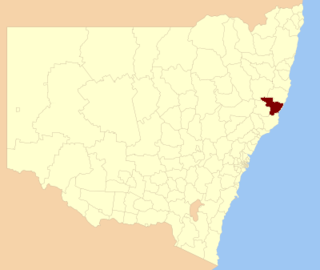
The Greater Taree City Council (GTCC) was a local government area on the Mid North Coast of New South Wales, Australia, until 12 May 2016 when it was amalgamated to form part of the Mid-Coast Council. It was originally formed in 1981 from the Manning Shire, and the Taree and Wingham Municipal Councils. The council was centred on Taree, located adjacent to the Manning River, the Pacific Highway and the North Coast railway line.

Forster is a coastal town in the Mid North Coast region of New South Wales, Australia, in the Mid-Coast Council LGA, about 308 km north-north-east of Sydney. It is immediately adjacent to its twin, Tuncurry, which is the smaller of the two towns. Forster is known for its stunning waters and Manning Valley beauty.

Woodburn is a small highway town on the banks of the Richmond River in New South Wales, Australia. Until the town was bypassed in September 2020, the busy Pacific Highway passed through the centre of town. Woodburn is 712 km north of the state capital, Sydney, and 34 km south of the regional city of Lismore.

Maclean is a town in Clarence Valley local government area in the Northern Rivers region of New South Wales, Australia. It is on the Clarence River and near the Pacific Highway. At the 2021 census, Maclean had a population of 2,778, total urban area including Townsend and Gulmarrad is more than 8,304. The Maclean, Yamba and Iluka area known as the Lower Clarence had a combined population of 17,533. Its industries are tourism, sugar cane production, farming and river-prawn trawling. Together with Grafton, Maclean is the shared administrative centre for the Clarence Valley Council local government area.
Failford is a locality in the Mid-Coast Council local government area on the Mid North Coast of New South Wales, Australia. Located to the east of the Pacific Highway, Failford is about 17 km (11 mi) northwest of Forster. At the 2011 census it had a population of 495.

Cobargo is a village in the south-east area of the state of New South Wales in Australia in Bega Valley Shire. At the 2016 census, Cobargo had a population of 776 people. It is 386 km south of Sydney on the Princes Highway between Narooma and Bega. The town suffered heavy losses during the 2019 bushfires.

Tooleybuc is a town in the western Riverina district of New South Wales, Australia. The town is located on the Mallee Highway, 919 kilometres (571 mi) southwest of the state capital, Sydney and 381 kilometres (237 mi) north west of Melbourne. Situated on the banks of the Murray River across from Piangil in the neighbouring state of Victoria, at the 2011 census, Tooleybuc has a population of 277. The town is in the Murray River Council local government area. The Tooleybuc Bridgekeepers Cottage close to the Tooleybuc Bridge is of particular local historic interest. It is open to the public.
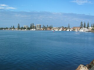
Tuncurry is a coastal town in the Mid North Coast region of New South Wales, Australia, in the Mid-Coast Council LGA, about 307 km (191 mi) north north east of Sydney. It is immediately adjacent to its twin town of Forster, which is the larger of the two towns.
The Sydney–Melbourne rail corridor is approximately 953-kilometre (592-mile) standard-gauge railway corridor that runs between Sydney and Melbourne (Victoria), the two largest cities in Australia. Freight and passenger services operate along the route, including the NSW TrainLink XPT passenger service.

Wallamba River, a watercourse of the Mid-Coast Council system, is located in the Mid North Coast district of New South Wales, Australia.
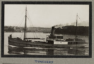
The Tuncurry was a wooden carvel screw steamer built in 1903 at Cape Hawke in the Australian state of New South Wales, that was wrecked when she sprang a leak whilst carrying explosives, cement, whiskey, jam and other general cargo between Sydney and Brisbane. She was lost off Barrenjoey Head, Broken Bay, New South Wales on 22 October 1916.

MidCoast Council is a local government area that is located in the Mid North Coast region of New South Wales, Australia. The council was formed on 12 May 2016 through a merger of the Gloucester Shire, Great Lakes and City of Greater Taree Councils.


