
Boonah is a rural town and locality in the Scenic Rim Region, Queensland, Australia. In the 2016 census, the locality of Boonah had a population of 2,484 people.

Inala is a south-western suburb in the City of Brisbane, Queensland, Australia. In the 2021 census, Inala had a population of 15,273 people.

Esk is a rural town and locality in the Somerset Region in South East Queensland, Australia. In the 2021 census, the locality of Esk had a population of 1,641 people.

Biggenden is a rural town and locality in the North Burnett Region, Queensland, Australia. In the 2016 census, Biggenden had a population of 845 people.
Landis is a village in the Canadian province of Saskatchewan within the Rural Municipality of Reford No. 379 and Census Division No. 13. The village is about 51 km (32 mi) south of Wilkie and about 128 km (80 mi) west from the City of Saskatoon on Highway 14. From 1907 to 1909, the post office at Section 23, Township 37, Range 18 west of the 3rd meridian, was known as Daneville. In 1925, Landis was a Canadian National Railway Station on the Grand Trunk Pacific Railway line.

Myall River, an open semi-mature brackish freshwater barrier estuary of the Mid-Coast Council system, is located in the Mid North Coast region of New South Wales, Australia.

Mount Crosby is a semi-rural outer western locality in the City of Brisbane, Queensland, Australia. In the 2021 census, Mount Crosby had a population of 1,860 people.
Ellen Grove is an outer south-western suburb in the City of Brisbane, Queensland, Australia. In the 2016 census, Ellen Grove had a population of 2,906 people.
Montville is a rural town and locality in the Sunshine Coast Region, Queensland, Australia. In the 2016 census, the locality of Montville had a population of 970 people.
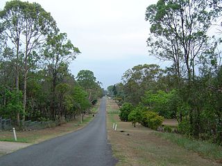
Clarendon is a rural locality in the Somerset Region, Queensland, Australia. In the 2016 census, Clarendon had a population of 244 people.
Coolongolook River, a watercourse of the Mid-Coast Council system, is located in the Mid North Coast district of New South Wales, Australia.
Mammy Johnsons River, a mostly perennial river of the Mid-Coast Council system, is located in the Mid North Coast and Upper Hunter regions of New South Wales, Australia.
The Branch River, a watercourse of the Mid-Coast Council system, is located in the Mid North Coast and Upper Hunter regions of New South Wales, Australia.

Wallamba River, a watercourse of the Mid-Coast Council system, is located in the Mid North Coast district of New South Wales, Australia.
Wallingat River, a watercourse of the Mid-Coast Council system, is located in the Mid North Coast district of New South Wales, Australia.

Wang Wauk River, a perennial river of the Great Lakes system, is located in the Mid North Coast region of New South Wales, Australia.

Darawank is a small village area located approximately 10 km north of Forster and Tuncurry along the Lakes Way Road towards Taree where the road meets the Wallamba River. It is located at 32.12°S 152.48°E.
Wallis Island is a nature reserve near Forster, New South Wales, Australia. It was created in January 1983 and covers an area of 584ha. It sits within Wallis Lake, just south of the Coolongolook River. It is known for the Forster Airport and a $20 million Australian chateau which was built on land reportedly bought for $290,000 in 1996.
