Related Research Articles
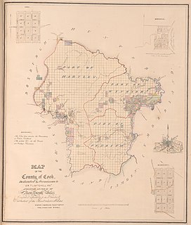
Cook and Westmoreland was an electoral district of the Legislative Assembly in the Australian state of New South Wales in the first and second Parliaments (1856–1859), named after Cook and Westmoreland counties in the Blue Mountains, Lithgow and Oberon areas. It elected two members simultaneously, with voters casting two votes and the first two candidates being elected. It was largely replaced by Hartley, however both members moved to other electorates, James Martin became the member for East Sydney, while Robert Jamison became the member for Nepean.
Sydney Hamlets was an electoral district of the Legislative Assembly in then British colony of New South Wales from 1856 to 1859, including what were then outer suburbs of Sydney and are now the inner suburbs of Paddington, Surry Hills, Redfern, Chippendale, Glebe, Camperdown, O'Connell Town, Balmain, North Sydney, Kirribilli and McMahons Point.
Cumberland was an electoral district of the Legislative Assembly in the Australian state of New South Wales from 1856 to 1859, in Cumberland County, which includes Sydney. It included all of the county north of Parramatta Road and the Great Western Highway, except for the urban electorates of Sydney (City), Sydney Hamlets, Parramatta and Cumberland Boroughs, which included Richmond and Windsor. It elected two members simultaneously, with voters casting two votes and the first two candidates being elected. It was abolished in 1859 and the district was divided between Central Cumberland, Windsor, Nepean and St Leonards.
North Eastern Boroughs was an electoral district of the Legislative Assembly in the Australian state of New South Wales from 1856 to 1859, that included the towns of Newcastle, Stockton and Raymond Terrace. It was partly replaced by the electoral district of Newcastle and the electoral district of Hunter.
Northumberland and Hunter was an electoral district for the Legislative Assembly in the Australian state of New South Wales from 1856 to 1859, in the Newcastle area and named after Northumberland County and the Hunter River. It elected three members, with voters casting three votes and the first three candidates being elected. For the 1859 election it was replaced by Northumberland and the remainder was divided between Hunter and Lower Hunter.
Western Division of Camden was an electoral district for the Legislative Assembly in the Australian state of New South Wales from 1856 to 1857. Its name was changed to West Camden between 1858 and 1859, when it was replaced by the electoral district of Camden. It elected two members simultaneously, with voters casting two votes and the first two candidates being elected. The electorate was based on western Camden County, which adjoins the Cumberland County to the south, including the Southern Highlands and, to the east, the Illawarra.
Cumberland Boroughs was an electoral district of the Legislative Assembly in the Australian state of New South Wales from 1856 to 1859, consisting of the Cumberland County towns of Richmond, Windsor, Liverpool and Campbelltown, but not the surrounding rural areas, which were in Cumberland and Cumberland. The district was abolished in 1859, with Richmond and Windsor forming the new electorate of Windsor, Campbelltown was included in Narellan and Liverpool became part of Central Cumberland.

Gloucester and Macquarie was an electoral district of the Legislative Assembly in the Australian state of New South Wales in the first and second Parliaments (1856-1859), named after Gloucester and Macquarie counties on the Mid North Coast. It was abolished in 1859 with Macquarie, the north-east of Gloucester and the Macleay River area forming the new district of Electoral district of Hastings, while the rest of Gloucester was split between Lower Hunter, Northumberland and The Williams.
King and Georgiana was an electoral district of the Legislative Assembly in the Australian state of New South Wales from 1856 to 1859, named after King and Georgiana counties, including Yass and Taralga. Its only member was Peter Faucett. It was largely replaced by the electoral district of Yass Plains in 1859.
Phillip, Brisbane and Bligh was an electoral district of the Legislative Assembly in the Australian state of New South Wales from 1856 to 1859. It included Phillip, Brisbane and Bligh counties, including Scone, Murrurundi, Dunedoo and Mudgee. It was replaced by Upper Hunter and Mudgee.
Eastern Division of Camden was an electoral district for the Legislative Assembly in the then British colony of New South Wales from 1856 to 1857. Its name was changed to East Camden in January 1858, and it was largely replaced by the district of Illawarra in June 1859.
Braidwood was an electoral district of the Legislative Assembly in the Australian state of New South Wales, one of 62 new districts created established under the Electoral Act 1858 (NSW), in the 1858 redistribution. Braidwood was named after and included the town of Braidwood. It replaced parts of the districts of United Counties of Murray and St Vincent and the Southern Boroughs. In 1904 it was largely absorbed into the district of Queanbeyan. The balance of the district went to the new district of The Clyde.
St Vincent was an electoral district of the Legislative Assembly in the Australian state of New South Wales existing from 1856 until 1859. It was named after St Vincent County. It included Batemans Bay and the Jervis Bay area. It was largely replaced by Shoalhaven, while some of the southern portions became part of Braidwood and Eden.
New England and Macleay was an electoral district of the Legislative Assembly in the Australian state of New South Wales from 1856 to 1859, in the Northern Tablelands region of New England and part of the Mid North Coast region, including the area to the north of the Macleay River. but excluding the area south of the Macleay River which was included in the Counties of Gloucester and Macquarie. To the north was the electorate of Clarence and Darling Downs and to the west the electorate of Liverpool Plains and Gwydir. It elected two members, with voters casting two votes and the first two candidates being elected. It was partly replaced by New England.
Roxburgh was an electoral district of the Legislative Assembly in the Australian state of New South Wales from 1856 to 1859, named after Roxburgh County. It included Sofala. For the 1859 election the district divided, principally the northern portion in Hartley and the south western portion in East Macquarie.
Western Boroughs was an electoral district for the Legislative Assembly in the Australian state of New South Wales from 1856 to 1859. It included the towns of Bathurst, Carcoar and Kelso, while the surrounding rural areas were in Bathurst (County) and Cook and Westmoreland. It was replaced by Bathurst and Carcoar.
Wellington and Bligh was an electoral district of the Legislative Assembly in the Australian state of New South Wales, named after Wellington County and Bligh County, and including Mudgee. There were also separate electoral districts of Wellington (County), covering part of Wellington County, and Phillip, Brisbane and Bligh, including part of Bligh County. In 1859, it was largely replaced by Mudgee.
The 1856 New South Wales colonial election was to return 54 members of Legislative Assembly composed of 34 electoral districts with 18 returning 1 member, 13 returning 2 members, two returning 3 members and one returning 4 members, all with a first past the post system. In multi-member districts, because each voter could cast more than one vote, it is not possible to total the votes to show the number of voters and voter turnout in these districts is estimated. 8 members from 6 districts were returned unopposed.
The 1858 New South Wales colonial election was to return 54 members of Legislative Assembly composed of 34 electoral districts with 18 returning 1 member, 13 returning 2 members, two returning 3 members and one returning 4 members, all with a first past the post system. In multi-member districts, because each voter could cast more than one vote, it is not possible to total the votes to show the number of voters and voter turnout in these districts is estimated. 17 members from 14 districts were returned unopposed. The electoral districts and boundaries were established under the Electoral Act 1851 (NSW) for the former Legislative Council.
Cumberland North Riding, an electoral district of the Legislative Assembly in the Australian state of New South Wales was created in 1856 and abolished in 1859.
References
- ↑ "An Act to amend the Electoral Law.". Act No. 20 of 24 November 1858 (PDF). Australasian Legal Information Institute. Retrieved 25 June 2019.
- ↑ "Mr George Henry Cox (1824-1901)". Former Members of the Parliament of New South Wales . Retrieved 23 May 2019.
- ↑ Green, Antony. "1856 Wellington (County)". New South Wales Election Results 1856-2007. Parliament of New South Wales . Retrieved 21 March 2015.
- ↑ Green, Antony. "1858 Wellington County". New South Wales Election Results 1856-2007. Parliament of New South Wales . Retrieved 12 June 2019.
| General elections |
| ||||
|---|---|---|---|---|---|
| Referendums | |||||
| Other |
| ||||