
Gosford is a waterfront city at the northern end of Brisbane Water on the Central Coast in the state of New South Wales, Australia. The Gosford waterfront is known for its boating and scenic views on the shores of Brisbane Water. Gosford is the main commercial hub and gateway of the Central Coast. It is situated approximately 77 km (48 mi) north of Sydney and 86 km (53 mi) south of Newcastle. Gosford is located in the local government area of the Central Coast Council.

The Central Coast is a peri-urban region lying on the Pacific Ocean in northern-eastern New South Wales, Australia. The region is situated north of Sydney, which is filled with subtropical national parks, forests and also encompasses the major coastal waterways of Brisbane Water, Tuggerah Lakes and southern Lake Macquarie. The region's hinterland, which has fertile valleys, rural farmland and wineries, and also includes the Watagan Mountains. The Central Coast is known for its regional coastal towns like Terrigal, The Entrance, Ettalong Beach, Budgewoi and Bateau Bay with resorts and holiday parks, which feature many expansive beaches and lagoons with surfing and coastal tracks, as well as scenic views. Gosford is the main commercial hub and gateway.
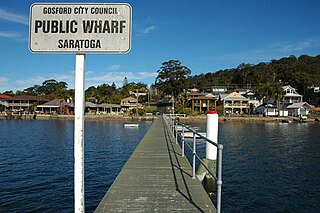
Saratoga is a residential south-eastern village and suburb of the Central Coast region of New South Wales, Australia, located on a peninsula of Brisbane Water and part of the Central Coast Council local government area. The suburb is characterised by its largely settled shoreline, with houses extending up coastal slopes to the base of the tall hills that comprise the core of the peninsula.

Kanwal is a suburb just west of the Tuggerah Lake on the Central Coast, New South Wales, Australia. It is part of the Central Coast Council local government area and is approximately nine kilometres north east of Wyong and six kilometres west of the Pacific Ocean.

Shelly Beach is a coastal suburb of the Central Coast region of New South Wales, Australia, located east of Tuggerah Lake and bordering the Pacific Ocean south of The Entrance. It is part of the Central Coast Council local government area. It is 66 km south of Newcastle & 93 km north of Sydney. Shelly Beach is considered one of the most popular surfing beaches on the Central Coast.

Box Head is a coastal locality in the Central Coast Council local government area located on the Central Coast of New South Wales, Australia. It is within Bouddi National Park which includes the island of Lion Island.

Koolewong is a suburb of the Central Coast region of New South Wales, Australia between Gosford and Woy Woy, and is mostly on a hill overlooking Brisbane Water. It is part of the Central Coast Council local government area.

Matcham is a semi-rural suburb of the Central Coast region of New South Wales, Australia. It is part of the Central Coast Council local government area and included in the electoral district of Terrigal. It has a hall and a historic church, St. George's Church, established in 1925.

Mooney Mooney is a small waterfront village and suburb of the Central Coast region of New South Wales, Australia. It is located in the Central Coast Council local government area at the end of a peninsula extending southwards into the Hawkesbury River, that is situated 50 kilometres (31 mi) north of Sydney. Mooney Mooney has two islands which are Peat Island and Spectacle Island.

Mount Elliot is a semi-rural locality of the Central Coast region of New South Wales, Australia, 9 kilometres (6 mi) east-north-east of Gosford's central business district. It is part of the Central Coast Council local government area.
Point Clare is a suburb of the Central Coast region of New South Wales, Australia located approximately 75 kilometres (47 mi) north of Sydney and 4 kilometres (2 mi) south-west of Gosford's central business district on the western shore of Brisbane Water. It is part of the Central Coast Council local government area.

Point Frederick is a suburb of the Central Coast region of New South Wales, Australia on a peninsula protruding into Brisbane Water 2 kilometres (1 mi) south-southeast of Gosford's central business district. It is part of the Central Coast Council local government area.

St Huberts Island is a canal estate and suburb of the Central Coast region of New South Wales, Australia connected to the mainland at Daleys Point. It is part of the Central Coast Council local government area.
Somersby is a semi-rural locality of the Central Coast region of New South Wales, Australia, to the northwest of Gosford along the Pacific Highway. It is part of the Central Coast Council local government area.

Spencer is a suburb of the Central Coast region of New South Wales, Australia. It is located on the north bank of the Hawkesbury River just upstream of that river's confluence with Mangrove Creek. Spencer is part of the Central Coast Council local government area.

Tascott is a suburb of the Central Coast region of New South Wales, Australia between Gosford and Woy Woy on Brisbane Water's western shore. It is part of the Central Coast Council local government area.
Yattalunga is a south-eastern suburb of the Central Coast region of New South Wales, Australia. It is part of the Central Coast Council local government area.
Lower Mangrove is a suburb of the Central Coast region of New South Wales, Australia, located about 8 kilometres (5 mi) upstream and north of Spencer along Mangrove Creek. It is part of the Central Coast Council local government area.
Mangrove Creek is a suburb of the Central Coast region of New South Wales, Australia, located about 14 kilometres (9 mi) upstream and north of Spencer along the Mangrove Creek watercourse. It is part of the Central Coast Council local government area.
ABC Central Coast is an ABC Local Radio station based in Gosford and broadcasting to the Central Coast region in New South Wales. The transmission area of the station stretches from Woy Woy to The Entrance. The signal is notoriously weak in many valley areas of the region.
