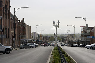
Bathurst is a city in the Central Tablelands of New South Wales, Australia. Bathurst is about 200 kilometres (120 mi) west-northwest of Sydney and is the seat of the Bathurst Regional Council. Founded in 1815, Bathurst is the oldest inland settlement in Australia and had a population of 37,396 in 2021.

The Hills Shire is a local government area in the Greater Sydney region of Sydney, New South Wales, Australia. The area is north-west of the Sydney central business district, and encompasses 401 square kilometres (155 sq mi) stretching from the M2 Hills Motorway in the south to Wisemans Ferry on the Hawkesbury River in the north. The Hills Shire had a population of 191,876 as of the 2021 census.

Carcoar is a small town in the Central West region of New South Wales, Australia, in Blayney Shire. In 2021, the town had a population of 271 people. It is situated just off the Mid-Western Highway 258 km west of Sydney and 52 km south-west of Bathurst and is 720 m above sea level. It is located in a small green valley, with the township and buildings on both banks of the Belubula River. It is the third oldest settlement west of the Blue Mountains. Carcoar is a Gundungurra word meaning either 'frog' or 'kookaburra'. Nearby towns are Blayney, Millthorpe, Mandurama, Neville, Lyndhurst and Barry
Lyndhurst is a small village in New South Wales, Australia in Blayney Shire. It is 4 kilometres west of Mandurama or about 269 km west of Sydney and 63 km south-west of Bathurst just off the Mid-Western Highway New South Wales. Once serving as the major centre for basic goods and needs to the nearby Junction Reefs goldfields. At the 2016 census, Lyndhurst had a population of 267 people.
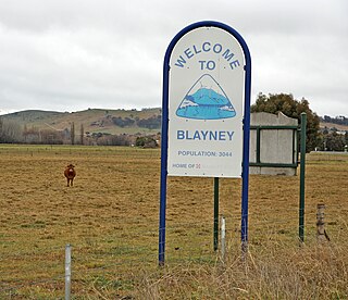
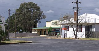
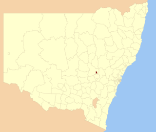
Blayney is a farming town and administrative centre with a population of 2,997 in 2021, in the Central West region of New South Wales, Australia. Situated on the Mid-Western Highway about 240 km (150 mi) west of Sydney, 35 km (22 mi) west of Bathurst and 863 m (944 yd) above sea-level, Blayney is the seat of Blayney Shire Council.
The City of Orange is a local government area in the Central West region of New South Wales, Australia. Based in Orange, the area is located adjacent to the Mitchell Highway and the Main Western railway line.

Parkes Shire is a local government area in the Central West region of New South Wales, Australia. The Shire is located adjacent to the Broken Hill railway line and the Newell Highway.

Walcha Shire is a local government area located in the New England region of New South Wales, Australia. The Shire is situated adjacent to the junction of the Oxley Highway and Thunderbolts Way and is 20 kilometres (12 mi) east of the Main North railway line passing through Walcha Road. The shire was formed on 1 June 1955 through the amalgamation of Apsley Shire and the Municipality of Walcha.

Hobbys Yards is a small village in the Central West region of New South Wales, Australia, in Blayney Shire. It is situated within an hour's driving time from the regional centres, townships, villages of Bathurst, Barry, Blayney, Neville and Trunkey Creek. At the 2006 census, Hobbys Yards locality had a population of 198 people, most of them living on neighbouring farms. The village is named after Thomas Hobby who accompanied John Oxley on his exploration expeditions, or his son.

Belubula River, a perennial river that is part of the Lachlan catchment within the Murray–Darling basin, is located in the central west region of New South Wales, Australia.

Carcoar Dam is a minor ungated concrete double parabolic arch dam with an uncontrolled overflow spillway across the Belubula River upstream of Carcoar in the central west region of New South Wales, Australia. The dam's purpose includes irrigation, water supply, and water conservation.

The Cliefden Caves is a heritage-listed geoheritage site in Mandurama, Cowra Shire, New South Wales, Australia. The caves comprise Ordovician fossil localities, limestone caves, a spring and tufa dams, and a site where limestone was first discovered in inland Australia.

Blayney railway station is a heritage-listed railway station on the Main Western line that serves Blayney, in the Central West region of New South Wales, Australia. The property was added to the New South Wales State Heritage Register on 2 April 1999.

The Armidale Region is a local government area in the New England and Northern Tablelands regions of New South Wales, Australia. This area was formed in 2016 from the merger of the Armidale Dumaresq Shire with the surrounding Guyra Shire.

Federation Council is a local government area located in the Murray region of New South Wales, Australia, formed in 2016 from the merger of the Corowa Shire with neighbouring Urana Shire.

The Dubbo Regional Council is a local government area located in the Central West and Orana regions of New South Wales, Australia. The council was formed on 12 May 2016 through a merger of the City of Dubbo and Wellington Council as part of a widespread council amalgamation program. It was initially named Western Plains Regional Council for almost four months, and its name was changed to Dubbo Regional Council on 7 September 2016.

The Young railway station is a heritage-listed former railway station in the South West Slopes region of New South Wales, Australia. It is located on the Blayney-Harden railway line, in the town of Young. It is also known as Young Railway Station and yard group. The railway station and associated yards were added to the New South Wales State Heritage Register on 2 April 1999.

Blayney Uniting Church is a heritage-listed Uniting church at Adelaide Street, Blayney, Blayney Shire, New South Wales, Australia. The property is owned by the Uniting Church in Australia. It was added to the New South Wales State Heritage Register on 2 April 1999.
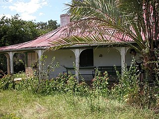
Cliefden is a heritage-listed homestead at 1521 Belubula Way, Mandurama, Blayney Shire, New South Wales, Australia. It is one of a group of historic sites labelled the Ben Hall Sites for their association with bushranger Ben Hall, along with Ben Hall's Death Site, the Bushranger Hotel, Escort Rock, the Grave of Ben Hall and Wandi. It was built from 1842. It was added to the New South Wales State Heritage Register on 8 October 2010.

Junction Reefs Dam is a heritage-listed former mining dam on the Belubula River at Lyndhurst, Blayney Shire, New South Wales, Australia. It was designed by Oscar Shulze and built by Schulze in 1896. It was the first multi-arch dam built in Australia. It is also known as Belubula Dam. The property is owned by Department of Planning and Infrastructure. It was added to the New South Wales State Heritage Register on 2 April 1999.


