Orange is a city in the Central Tablelands region of New South Wales, Australia. It is 254 km (158 mi) west of the state capital, Sydney [206 km (128 mi) on a great circle], at an altitude of 862 metres (2,828 ft). Orange had an estimated urban population of 40,493 as of June 2018 making the city a significant regional centre. A significant nearby landmark is Mount Canobolas with a peak elevation of 1,395 m (4,577 ft) AHD and commanding views of the district. Orange is situated within the traditional lands of the Wiradjuri Nation.

Menai is a suburb in southern Sydney, in the state of New South Wales, Australia 29 kilometres south of the Sydney central business district in the local government area of the Sutherland Shire.

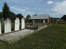
Carcoar is a town in the Central West region of New South Wales, Australia, in Blayney Shire. In 2016, the town had a population of 200 people. It is situated just off the Mid-Western Highway 258 km west of Sydney and 52 km south-west of Bathurst and is 720 m above sea level. It is located in a small green valley, with the township and buildings on both banks of the Belubula River. It is the third oldest settlement west of the Blue Mountains. Carcoar is a Gundungurra word meaning either frog or kookaburra. Nearby towns are Blayney, Millthorpe, Mandurama, Neville, Lyndhurst and Barry
Crookwell is a small town located in the Southern Tablelands of New South Wales, Australia, in the Upper Lachlan Shire. At the 2016 census, Crookwell had a population of 2,641. The town is at a relatively high altitude of 887 metres and there are several snowfalls during the winter months. The nearest major centre is the city of Goulburn which is about a half-hour drive to the south-east of the town. Crookwell is easily accessible to the state capital of Sydney and also the federal capital of Canberra.
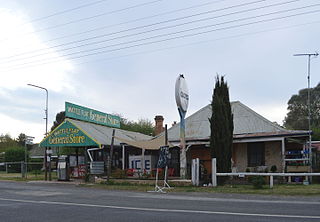
Neville is a small village in the south-east of New South Wales, Australia, in Blayney Shire. It is 60 km south west of Bathurst or about 16 km south-east of Mandurama. It is 940 metres above sea level and has a population of about 100.

Mandurama is a village in the Blayney Shire, New South Wales, Australia. At the 2016 census, Mandurama and the surrounding area had a population of 355 people.
Newbridge is a village of about 100 residents in New South Wales, Australia in Blayney Shire. It is approximately 30 km from Bathurst and 15 km from Blayney in the Central Tablelands of NSW. At the 2006 census, Newbridge had a population of 90 people.
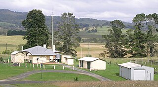
Barry is a small village in the Central West region of New South Wales, Australia, in Blayney Shire. It is situated within an hour's driving time of the townships and villages of Blayney, Millthorpe, Mandurama, Neville, Lyndhurst and Carcoar. In the 2016 census, a population of 166 people was recorded.
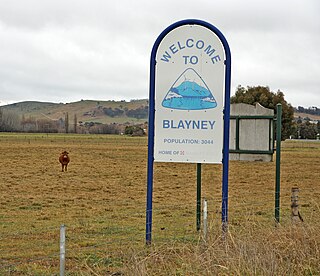
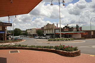
Blayney is a farming town and administrative centre with a population of 3,378 in 2016, in the Central West region of New South Wales, Australia. Situated on the Mid-Western Highway about 240 km (150 mi) west of Sydney, 35 km (22 mi) west of Bathurst and 863 m (944 yd) above sea-level, Blayney is the seat of Blayney Shire Council.

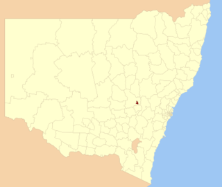
Blayney Shire is a local government area in the Central West region of New South Wales, Australia. The Shire is located adjacent to the Mid-Western Highway and the Main Western railway line, and is centred on the town of Blayney.
The City of Orange is a local government area in the central west region of New South Wales, Australia. Based in Orange, the area is located adjacent to the Mitchell Highway and the Main Western railway line.
Nowendoc is a parish and village on the Northern Tablelands, New South Wales, Australia. It is 360 km north of the state capital, Sydney, 66 km south of Walcha in the Walcha Shire local government area. A sealed road, Thunderbolts Way, is about three hundred metres to the south of Nowendoc and provides links to the south and north.
Perthville is a small town in New South Wales, Australia. The town is located on the Central Tablelands, approximately 10 kilometres (6.2 mi) from the regional city of Bathurst. The town has evolved over time due to road improvements to be a satellite suburb of Bathurst.

Blayney railway station is a heritage-listed railway station on the Main Western line in Blayney, Blayney Shire, New South Wales, Australia. The property was added to the New South Wales State Heritage Register on 2 April 1999.
Frogmore is a village in the Southern Tablelands of New South Wales, Australia. It was previously a mining town.
Gowrie is a locality situated 1.6 km to the West of the New England Highway and approximately 29 km South of Tamworth in the New England area of New South Wales.
Wattle Flat is a locality in the Bathurst Region of New South Wales, Australia. It had a population of 257 people as of the 2016 census. There is a small village of the same name, near the confluence of Big Oaky Creek and its tributary Solitary Creek.
Lyndhurst Shire was a local government area in the Central West region of New South Wales, Australia.
The Mid West Community Cup is a rugby league competition in the Central West area of New South Wales. The premiers are awarded the Blayney Citizens' Cup, the oldest continuously awarded trophy in Country Rugby League, with Neville the first recipients in 1913. For all intents and purposes, it is a third division competition in the Group 10/11 area.
Caloola is a locality in the Central West region of New South Wales. There once was a small village of the same name but it is a ghost town today. At the 2016 census, the locality had a population of 88.