
The City of Stirling is a local government area in the northern suburbs of the Western Australian capital city of Perth about 10 kilometres (6 mi) north of Perth's central business district. The City covers an area of 105.2 square kilometres (40.6 sq mi) and has a population of over 223,000, making it the largest local government area by population in Western Australia.

The Town of Cambridge is a local government area in the inner western suburbs of the Western Australian capital city of Perth, about 5 kilometres (3 mi) west of Perth's central business district and extending to the Indian Ocean at City Beach. The Town covers an area of 22.0 square kilometres (8.5 sq mi) and had a population of almost 29,000 as of the 2021 Census. It was originally part of the City of Perth before the restructuring by the Western Australian State Government in 1994.

The City of Canning is a local government area in the southeastern suburbs of the Western Australian capital city of Perth, about 10 kilometres (6 mi) southeast of Perth's central business district. The City covers an area of 64.8 square kilometres (25.0 sq mi) and had a population of approximately 90,000 as at the 2016 Census.

The City of Melville is a local government area in the southern suburbs of the Western Australian capital city of Perth, east of the port city of Fremantle and about 12 kilometres (7.5 mi) south of Perth's central business district. The City covers an area of 52.73 square kilometres (20.36 sq mi) and had a population of about 98,000 as at the 2016 Census.

The City of Swan is a local government area of Western Australia. It is in the eastern metropolitan region of Perth and includes the Swan Valley and 42 suburbs. It is centred approximately 20 km north-east of the Perth central business district. The City covers an area of 1,042 km2 and had an estimated population of 155,653 in 2020.

The Town of Victoria Park is a local government area of Western Australia. It covers an area of 17.62 km² in metropolitan Perth, the capital of Western Australia. It had a population of approximately 35,000 as at the 2016 census.

The City of Vincent is a local government area of Western Australia. It covers an area of approximately 10.4 square kilometres (4.0 sq mi) in metropolitan Perth, the capital of Western Australia, and lies about 3 km from the Perth CBD. The City of Vincent maintains 139 km of roads and 104 ha of parks and gardens. It had a population of over 33,000 at the 2016 Census.

The City of Wanneroo is a local government area with city status in the northern suburbs of Perth, Western Australia. It is centred approximately 25 kilometres (15.5 mi) north of Perth's central business district and forms part of the northern boundary of the Perth metropolitan area. Wanneroo encompasses the federal divisions of Cowan, Moore and Pearce.

The Shire of Augusta Margaret River is a local government area in the south-west corner of the South West region of Western Australia, approximately 270 kilometres (168 mi) south of Perth. The shire covers an area of 2,243 square kilometres (866 sq mi) and had a population of over 14,000 at the 2016 Census, about half of whom live in the towns of Margaret River and Augusta.
The Shire of Ashburton is one of the four local government areas in the Pilbara region of Western Australia, covering an area of 105,647 square kilometres (40,791 sq mi). It is named after the Ashburton River.

The City of Busselton is a local government area in the South West region of Western Australia, approximately 230 km (140 mi) south of Perth, the state capital. The city covers an area of 1,455 km2 (562 sq mi) and had a population of 40,640 as at the 2021 Census. It contains two large towns, Busselton and Dunsborough, and a number of smaller towns. The city office is located on Southern Drive, Busselton.

The Shire of Halls Creek is one of the four local government areas in the Kimberley region of northern Western Australia, covering an area of 143,030 square kilometres (55,224 sq mi), most of which is sparsely populated. The Shire's seat of government is the town of Halls Creek. Many Aboriginal communities are located within the shire.
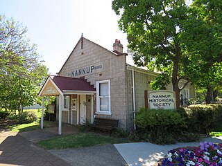
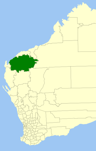
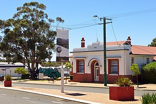
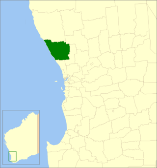
The Shire of Nannup is a local government area in the South West region of Western Australia, approximately 280 kilometres (174 mi) south of the state capital, Perth and 60 kilometres (37 mi) southeast of the coastal resort town of Busselton. Its seat of government is the town of Nannup, where about half of the Shire's population reside.

The Shire of Mundaring is a local government area in eastern metropolitan Perth, the capital of Western Australia. The Shire covers an area of 645 square kilometres (249 sq mi) and had a population of approximately 38,000 as at the 2016 Census.

The City of Albany is a local government area in the Great Southern region of Western Australia, about 410 kilometres (255 mi) south-southeast of Perth, the capital of Western Australia. It covers an area of 4,312.3 square kilometres (1,665 sq mi), including the Greater Albany metropolitan area and the Port of Albany, as well as the surrounding agricultural district and some national parks. The City of Albany had a population of over 36,000 at the 2016 census.

The City of Armadale is a local government area in the southeastern suburbs of the Western Australian capital city of Perth, about 28 kilometres (17.4 mi) southeast of Perth's central business district. The City covers an area of 560 square kilometres (216 sq mi), much of which is state forest rising into the Darling Scarp to the east, and had a population of almost 80,000 as at the 2016 Census. At the 2021 census, the population had risen to 94,184.
The Shire of Gnowangerup is a local government area in the Great Southern region of Western Australia, about 120 kilometres (75 mi) north of Albany and about 370 kilometres (230 mi) southeast of the capital, Perth. The Shire covers an area of 4,268 square kilometres (1,648 sq mi), and its seat of government is the town of Gnowangerup.
The Shire of Gingin is a local government area in the Wheatbelt region of Western Australia, just beyond the northern fringe of the Perth metropolitan area. The Shire covers an area of 3,211 square kilometres (1,240 sq mi) and its seat of government is the town of Gingin.

The Shire of Jerramungup is a local government area in the Great Southern region of Western Australia, about 180 kilometres (112 mi) northeast of Albany and about 440 kilometres (273 mi) southeast of the state capital, Perth. The Shire covers an area of 6,507 square kilometres (2,512 sq mi) with Bremer Bay its largest town. The seat of government is the town of Jerramungup.

The Shire of Northampton is a local government area in the Mid West region of Western Australia, about 50 kilometres (30 mi) north of Geraldton and about 460 kilometres (290 mi) north of the state capital, Perth. The Shire covers an area of 13,738 square kilometres (5,304 sq mi), and its seat of government is the town of Northampton, with the largest settlement being Kalbarri.
