
Tathra is a seaside town on the Sapphire Coast found on the South Coast, New South Wales, Australia. As at the 2016 census, Tathra had a population of 1,675.

Greater Hume Shire is a local government area in the Riverina region of southern New South Wales, Australia. The Shire was formed in 2004 incorporating Culcairn Shire, the majority of Holbrook Shire and part of Hume Shire. The shire had an estimated population of 10,137 as at 2012.

Moss Vale is a town in the Southern Highlands of New South Wales, Australia, in the Wingecarribee Shire. It is located on the Illawarra Highway, which connects to Wollongong and the Illawarra coast via Macquarie Pass.
Towrang is a village in the Southern Tablelands of New South Wales, Australia, in Goulburn Mulwaree Council. It is approximately 13 kilometres (8.1 mi) north of Goulburn on the Hume Highway 180 kilometres (110 mi) south from Sydney. At the 2016 census, Towrang had a population of 171.

Macarthur is a region in the south-west part of the Greater Sydney area, in the state of New South Wales, Australia. The region includes the local government areas of the City of Campbelltown, Camden Council, and Wollondilly Shire. It covers an area of 3,067 square kilometres and has a population of close to 310,000 residents. The region geographically forms the foothills between the Blue Mountains and Southern Highlands regions.

Picton is a small town in the Macarthur Region of New South Wales, Australia, in the Wollondilly Shire, in south-western Sydney. The town is located approximately 90 kilometres south-west of the Sydney CBD, close to Camden and Campbelltown. It is also the administrative centre of Wollondilly Shire.
Yanderra is a small village that is located in the Macarthur Region of Sydney in New South Wales, Australia. Yanderra is the southernmost suburb of Sydney that is located on the Hume Highway.

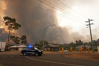
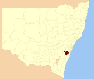
Wollondilly Shire is a periurban local government area, located on the south west fringe of the Greater Sydney area in New South Wales, Australia, parts of which fall into the Macarthur, Blue Mountains and Central Tablelands regions in the state of New South Wales, Australia. Wollondilly is seen as the transition between Regional NSW and the Greater Sydney Region, and is variously categorised as part of both. Wollondilly Shire was created by proclamation in the NSW Government Gazette on 7 March 1906, following the passing of the Local Government (Shires) Act 1905, and amalgamated with the Municipality of Picton on 1 May 1940.
Wingecarribee Shire is the local government area of the Southern Highlands in the state of New South Wales, Australia. The Wingecarribee Shire is around 110 kilometres (70 mi) southwest of Sydney and is part of regional Capital Country and to some extent can be considered part of the Southern Tablelands.

Yerrinbool is one of the Northern Villages of the Southern Highlands of New South Wales, Australia, in the Wingecarribee Shire, and is accessible from the Hume Highway and is about a 12 km (7.5 mi) drive from nearby Mittagong. It is 7 km (4.3 mi) to Hill Top as the crow flies, accessible by foot via a fire trail. It is on the western edge of the Upper Nepean Nature Reserve, a vast area of forest, lakes and dams between Yerrinbool and the coastal communities around Wollongong. Yerrinbool was previously officially known as the Town of Yerrinbool. It is located on the historic Old Hume Highway.
Bargo is a town in the Macarthur Region of Sydney in New South Wales, Australia, in the Wollondilly Shire. It is located approximately halfway between Campbelltown and Bowral, about 100 km south west of the Sydney CBD.
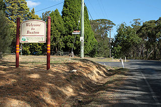
Buxton is a small village in Macarthur Region of Sydney in New South Wales, Australia, in Wollondilly Shire. At the 2021 census, Buxton had a population of 2,071 people. Its name comes from the town of Buxton, Derbyshire.

Ballina Shire is a local government area in the Northern Rivers region of New South Wales, Australia. The Shire was formed on 1 January 1977 by the amalgamation of the Municipality of Ballina and Tintenbar Shire. The Shire is located adjacent to the Tasman Sea and the Pacific Highway. The council seat is located in the town of Ballina. The population of the Ballina Shire area was 46,850 in 2022.

Gunnedah Shire is a local government area in the North West Slopes region of New South Wales, Australia. The Shire is located adjacent to the Liverpool Plains in the Namoi River valley and is traversed by the Oxley Highway and the Kamilaroi Highway.

Tahmoor is a small town in the Macarthur Region of New South Wales, Australia, in Wollondilly Shire.

The Shire of Burke is a local government area in North West Queensland, Australia. The shire lies on the south coast of the Gulf of Carpentaria and abuts the border with the Northern Territory. It covers an area of 39,864 square kilometres (15,391.6 sq mi), and has existed as a local government entity since 1885. The major town and administrative centre of the shire is Burketown.

Couridjah is a small town in the Macarthur Region of New South Wales, Australia, in Wollondilly Shire. It was previously known officially as "Village of Couridjah". At the 2016 census, Couridjah had a population of 303.

The Bargo Rural Fire Brigade is a unit of the New South Wales Rural Fire Service that services the local Bargo and Wollondilly Shire community in New South Wales, Australia. The brigade provides help to return normality to residents and visitors of the Wollondilly Shire in cases of bush fire. The brigade primarily services the Bargo area, including the Hume Highway from Picton Road, Wilton to Yanderra.

Cullerin is a small township in the Southern Tablelands of New South Wales, Australia. It is on the Old Hume Highway and Main South railway line in Upper Lachlan Shire. The Cullerin railway station opened in 1880 and closed in 1973. At the 2016 census, it had a population of 38.
Louise Milligan is an Australian author and investigative reporter for the ABC TV Four Corners program. As of March 2021, she is the author of two award-winning non-fiction books. Her first novel, Pheasants Nest, was published in 2024.

