
Thirlmere is a small semi-rural town in the Macarthur Region of Sydney in New South Wales, Australia, in the Wollondilly Shire. Popularly known for its railway origins, the town is located 89 km south west of the Sydney Central Business District. At the 2021 census, Thirlmere had a population of 4,986.
Menangle Park is a suburb in Sydney the state of New South Wales, Australia. Menangle Park is located 56 kilometres south-west of the Sydney central business district, in the local government area of the City of Campbelltown. Menangle Park is a largely rural area and is part of the Macarthur region.

The Southern Highlands Line (SHL) is an intercity rail service operated by NSW TrainLink that services the Macarthur, Southern Highlands and Southern Tablelands regions of New South Wales. First operating in 1869, the service runs from Campbelltown across the Main Southern railway line through to Goulburn, with peak hour services extending the route to Central. The railway service operates alongside a bus route from Picton to Bowral, operating on the route of the Picton – Mittagong loop railway line, and a regional coach service from Bundanoon to Wollongong on the South Coast Line, operating on the corridor of the Unanderra–Moss Vale railway line.

Macarthur is a region in the south-west part of the Greater Sydney area, in the state of New South Wales, Australia. The region includes the local government areas of the City of Campbelltown, Camden Council, and Wollondilly Shire. It covers an area of 3,067 square kilometres and has a population of close to 310,000 residents. The region geographically forms the foothills between the Blue Mountains and Southern Highlands regions.
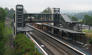
Picton railway station is a heritage-listed railway station located on the Main Southern line in the south-western Sydney suburb of Picton in the Wollondilly Shire local government area of New South Wales, Australia. It was built from 1863 to 1919. It is also known as the Picton Railway Station group. The property was added to the New South Wales State Heritage Register on 2 April 1999. The station opened on 1 July 1869. The station is unusually sited, with southbound journeys actually heading north out of the station before traversing a 225 degree horseshoe curve to again head south, and likewise northbound services heading south before rounding a number of curves to resume their true direction.

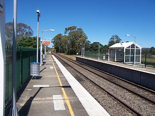
Tahmoor railway station is a heritage-listed railway station located on the Main Southern line in the town of Tahmoor, part of the Wollondilly Shire local government area of New South Wales, Australia. The property was added to the New South Wales State Heritage Register on 2 April 1999 where it is also known as the Tahmoor Railway Station Group and Lupton's Inn. The station opened on 13 July 1919 at the same time as a new alignment between Picton and Mittagong railway stations.
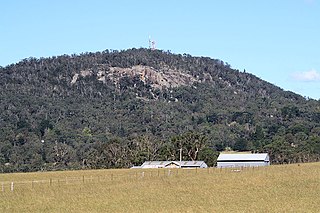
Mount Gibraltar is a mountain with an elevation of 863 metres (2,831 ft) AHD that is located in the Southern Highlands region, between Bowral and Mittagong, in New South Wales, Australia. Further west is Berrima.

Menangle is a village in the Macarthur region of New South Wales, Australia.

Wollondilly Shire is a periurban local government area, located on the south west fringe of the Greater Sydney area in New South Wales, Australia, parts of which fall into the Macarthur, Blue Mountains and Central Tablelands regions in the state of New South Wales, Australia. Wollondilly is seen as the transition between Regional NSW and the Greater Sydney Region, and is variously categorised as part of both. Wollondilly Shire was created by proclamation in the NSW Government Gazette on 7 March 1906, following the passing of the Local Government (Shires) Act 1905, and amalgamated with the Municipality of Picton on 1 May 1940.

Yerrinbool is one of the Northern Villages of the Southern Highlands of New South Wales, Australia, in the Wingecarribee Shire, and is accessible from the Hume Highway and is about a 12 km (7.5 mi) drive from nearby Mittagong. It is 7 km (4.3 mi) to Hill Top as the crow flies, accessible by foot via a fire trail. It is on the western edge of the Upper Nepean Nature Reserve, a vast area of forest, lakes and dams between Yerrinbool and the coastal communities around Wollongong. Yerrinbool was previously officially known as the Town of Yerrinbool. It is located on the historic Old Hume Highway.
Bargo is a town in the Macarthur Region of Sydney in New South Wales, Australia, in the Wollondilly Shire. It is located approximately halfway between Campbelltown and Bowral, about 100 km south west of the Sydney CBD.
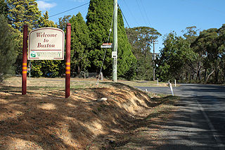
Buxton is a small village in Macarthur Region of New South Wales, Australia, in Wollondilly Shire. At the 2021 census, Buxton had a population of 2,071 people. Its name comes from the town of Buxton, Derbyshire.
Balmoral is a Northern Village of the Southern Highlands area of New South Wales, Australia. It is the northernmost village in Wingecarribee Shire.

Douglas Park is a town of the Macarthur Region in New South Wales, Australia in Wollondilly Shire. It is near the Hume Highway, the F5 Freeway and on the Main Southern railway line. Its station is served by NSW TrainLink's Southern Highlands Line. It is about 80 km southwest of Sydney. In 2016, Douglas Park had a population of 1,362.
The Picton–Mittagong Loop Line is a partly disused railway line between the towns of Picton and Mittagong in the Southern Highlands of New South Wales, Australia.

Colo Vale is a Northern Village of the Southern Highlands of New South Wales, Australia, in Wingecarribee Shire. Colo Vale is approximately 100 km south west on the Hume Highway from Sydney. It is situated 2 km north-west of Aylmerton, 5 km from the Hume Highway and 12 km drive to Mittagong. The surrounding area is part of the Parish of Colo which includes the villages of Aylmerton, Willow Vale, Alpine and Yerrinbool. Colo Vale has a mixed-business general store and many home-based businesses, including hairdressers, small manufacturing businesses and a large native plant nursery and a Public School on Wattle Street. A large sporting oval is located adjacent to the school with tennis courts, a community hall and a Rural Fire Service station.
Hill Top is a Northern Village of the Southern Highlands of New South Wales, Australia, in Wingecarribee Shire. Previous names of the village include Hilltop and Jellore. It is a 17 km drive to Mittagong and around 10 km drive to the Hume Highway via Colo Vale. It is roughly 6–8 km to Yerrinbool as the crow flies.

The New South Wales Z13 class was a class of 4-4-2T steam locomotives operated by the New South Wales Government Railways of Australia.

Locomotive 3642 is a two-cylinder, simple, non-condensing, coal-fired superheated, 4-6-0 36 class express passenger steam locomotive built for the New South Wales Government Railways in 1926 by Clyde Engineering. It is one of three 36 class locomotives that were preserved.
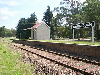
Couridjah railway station is a heritage-listed disused railway station located on the Picton – Mittagong loop railway line in the south-western Sydney settlement of Couridjah in the Wollondilly Shire local government area of New South Wales, Australia. The property was added to the New South Wales State Heritage Register on 2 April 1999.


